Situation Summary
Tonga remains a low-threat, stable environment with no verified security incidents, civil unrest, major crime spikes, or infrastructure disruptions reported in the last 24–48 hours. Open-source monitoring and regional security feeds describe routine political and administrative activity in the capital (Nukuʻalofa) and across the archipelago, with no public-order alerts or travel-risk escalations issued. Recent seismic activity (M 4.7 and M 4.4 earthquakes southeast and southwest of inhabited islands) poses natural-hazard awareness requirements but no immediate emergency response signals. The security trajectory remains stable with no indicators of imminent change.
Key Developments
- Nukuʻalofa – 17–18 June 2026: Government communications on budget priorities and 100-day policy outcomes continue; no associated protests, disorder, or political violence reported in media or social channels.
- Nationwide – 17–18 June 2026: No new foreign travel advisories, warnings, or security alerts specific to Tonga issued or escalated; country treated as routine-risk environment by regional monitors.
- Borders/Mobility – mid-June ongoing: E-passport administrative initiative progresses; no border closures, immigration disruptions, or mobility restrictions tied to security incidents in past 48 hours.
- Regional cooperation – May 2026 baseline: Australian Defence Force maritime patrols (coordinated with Tonga earlier in May) remain relevant to transnational-crime and maritime-domain awareness; no new joint operations or crisis responses reported in last 48 hours.
- Seismic activity – recent: M 4.7 earthquake centered 238 km SE of Hihifo and M 4.4 event 298 km SW of Houma recorded; no damage, casualties, or emergency declarations confirmed; standard natural-hazard monitoring applies.
- Drug-policy discussion – regional, not incident-driven: National drug taskforce and regional strategy statements reflect long-term governance; no credible reports of major busts, raids, or violence in last 48 hours.
- No verified incidents in 24–48h window: Regional security products monitoring civil unrest, conflict, crime, and infrastructure disruption report no new events in Tonga.
Highest-Risk Areas
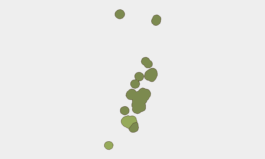
Tongatapu (risk score 45) dominates the sub-national ranking, reflecting Nukuʻalofa's role as the capital, seat of government, and largest urban center; routine political activity, administrative decision-making, and economic concentration naturally generate higher monitoring attention but do not currently translate to active threat events. Vavaʻu (28) and Haʻapai (22) carry secondary risk profiles tied to geographic remoteness, maritime-domain exposure, and regional transnational-crime dynamics; neither shows acute incidents in the current cycle. ʻEua and Ongo Niua (18 and 12, respectively) remain low-profile. Risk rankings reflect structural vulnerability and monitoring intensity rather than active conflict or crisis.
How GeoBit Would Assist
Security and duty-of-care teams operating in or responsible for Tonga would employ Intel Sweep and multi-language OSINT (X/Twitter, Telegram, local media) to maintain real-time visibility of political developments and public sentiment across Tongatapu and outer islands. AOI Monitoring & Early Warning on Nukuʻalofa and port facilities would flag political instability, labor unrest, or maritime anomalies before they escalate. Seismic and environmental data feeds would track earthquake and natural-hazard progression to inform business-continuity and evacuation planning.
7-Day Outlook
No material escalation of security risk is indicated over the next 7 days. Routine governance, administrative progress, and regional maritime cooperation are expected to continue. Natural-hazard awareness (seismic activity, cyclone-season preparedness) should remain part of operational planning, but no acute political, civil-unrest, or conflict triggers are evident on current trajectory.
Highest-Risk Areas — Ranked
| # | State / Region | Risk |
|---|---|---|
| 1 | Tongatapu | 45 |
| 2 | Vavaʻu | 28 |
| 3 | Haʻapai | 22 |
| 4 | ʻEua | 18 |
| 5 | Ongo Niua | 12 |
Sources
Previous Daily Briefs
A new Tonga brief is written every day — each with its own risk map and downloadable CSV. Here's the last week; use the calendar to go further back.
📅 Browse every day by calendar →
Highlighted days have a brief. Tap a day for that day's map & analysis, or “csv” for that day's dataset ($5).