Situation Summary
Vanuatu remains a low-threat operating environment globally (composite threat score 1), with no confirmed security incidents, civil unrest, or criminal attacks reported in the last 24–48 hours. Recent diplomatic friction with New Caledonia and France (signalled 2026-06-11) and two moderate seismic events (M 5.0 and M 4.5, both recent) have not generated secondary instability or widespread disruption. The country's security posture is stable, though Shefa Province (Port Vila area) carries elevated composite risk relative to other regions.
Key Developments
- Diplomatic tension with New Caledonia and France (2026-06-11). Vanuatu issued public disapprovals and reduced relations signals with both New Caledonian and French actors on the same date. No military or paramilitary response has been documented; statements appear to be political/rhetorical.
- Seismic activity (recent, dates unspecified). Two earthquakes—M 5.0 (68 km NNW of Isangel, Tafea Province) and M 4.5 (35 km E of Port-Olry, Sanma Province)—occurred within the monitoring window. No tsunami warnings, casualties, or infrastructure damage have been reported in open sources.
- No acute crime, protest, or infrastructure incidents confirmed in the last 24–48 hours. Web research yielded no corroborated discrete security events meeting reporting criteria. Routine policing operations (Operation Port Vila Reset 2026) continue over a multi-week cycle with no new adverse developments flagged.
Highest-Risk Areas
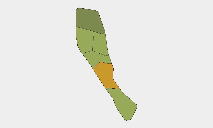
Shefa Province (risk score 72) dominates the country's risk profile, driven primarily by Port Vila's concentration of economic activity, maritime exposure, and routine law-enforcement operations. Penama (58) and Sanma (52) follow, reflecting inter-island connectivity and lower governance density in outer provinces. Malampa, Tafea, and Torba carry materially lower scores. Risk elevation in Shefa is not attributable to current acute threats but structural factors (population density, economic nodes); seismic activity in Tafea and Sanma has not escalated secondary risk. Teams with operations or personnel in Port Vila should maintain standard duty-of-care protocols; outer provinces present no elevated near-term concern.
How GeoBit Would Assist
Intel Sweep and OSINT fusion would provide continuous multi-language, multi-source monitoring of Vanuatu's political and security landscape, capturing early signals of diplomatic escalation or civil unrest before they reach mainstream reporting. AOI Monitoring & Early Warning on Shefa and Penama provinces would flag localized incidents (protests, crime clusters, infrastructure disruption) in real time, enabling rapid notification to corporate teams. Seismic and environmental monitoring (satellite imagery, environmental health data) can correlate earthquake activity with secondary risks—landslides, port closures, supply-chain disruption—informing business continuity decisions.
7-Day Outlook
The diplomatic friction with New Caledonia and France is likely to remain rhetorical and non-escalatory absent new statements or actions from Paris or Nouméa. Seismic risk remains within the region's normal envelope; no aftershock sequence or tsunami threat is anticipated. Overall security posture for Vanuatu is expected to remain stable over the next 7 days.
Highest-Risk Areas — Ranked
| # | State / Region | Risk |
|---|---|---|
| 1 | Shefa Province | 72 |
| 2 | Penama | 58 |
| 3 | Sanma | 52 |
| 4 | Malampa | 48 |
| 5 | Tafea | 45 |
| 6 | Torba | 35 |
Sources
Previous Daily Briefs
A new Vanuatu brief is written every day — each with its own risk map and downloadable CSV. Here's the last week; use the calendar to go further back.
📅 Browse every day by calendar →
Highlighted days have a brief. Tap a day for that day's map & analysis, or “csv” for that day's dataset ($5).