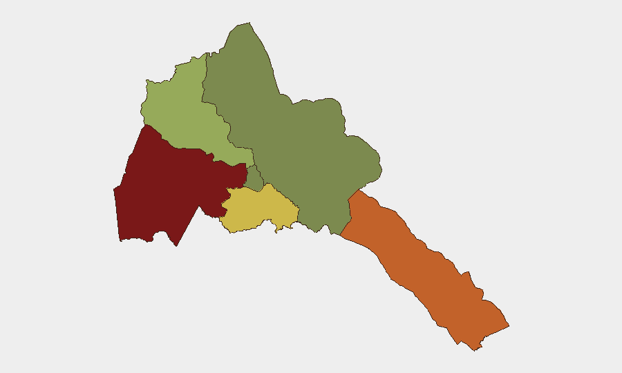
Situation Summary
Eritrea remains at low composite threat risk (#80 globally, score 24) with no confirmed security incidents occurring within its borders during the past week. However, escalating interstate tensions with Ethiopia over alleged Eritrean military incursions into northern Ethiopian territory (Tigray region) have raised the assessed risk of renewed cross-border conflict along the Eritrea–Ethiopia frontier. Both nations have made formal complaints to the UN Security Council, and military activity near the border has intensified materially over 8–13 October. The dispute remains unresolved and the trajectory is toward further entrenchment of positions rather than de-escalation.
Key Developments
- 8 October — Tigray, Ethiopia (Eritrean border area): Ethiopia accused Eritrean forces of repeated incursions into northern Tigray, claiming mechanized units advanced approximately 60 km into Ethiopian territory; Eritrea denied the allegation.
- 8–9 October — Adigrat–Idaga Hamus corridor, Tigray, Ethiopia: Unverified reports indicated Ethiopian military drones struck vehicles and personnel believed to belong to Eritrean forces; independent confirmation was not available.
- 9 October — Addis Ababa / United Nations: Ethiopia formally notified the UN Security Council of alleged Eritrean incursions and invoked self-defense rationale for military response, demanding withdrawal of Eritrean forces from Ethiopian territory.
- 10 October — Asmara / United Nations: Eritrea submitted a counter-complaint to the UN Security Council, characterizing Ethiopia's accusations as tantamount to a declaration of war and requesting UN-mandated "deterrent measures" against Addis Ababa.
- 10 October — Adigrat, Tigray, Ethiopia: Reports claimed Ethiopian government forces and allied militias retook the strategic town following alleged Eritrean withdrawal; the reported Eritrean presence was not independently verified.
- 10–11 October — Tigray–Eritrea border zone: Public accusations between Addis Ababa and Asmara intensified regarding troop deployments, militia support, and border violations; assessed risk of interstate conflict renewal rose materially.
- 11 October — Adigrat, Tigray, Ethiopia: Multiple sources reported Ethiopian government troops and allied forces entering or consolidating control of Adigrat, located approximately 30 km south of the Eritrean border.
- 13 October — Eritrea–Ethiopia border: Diplomatic and military tensions remained active, with no resolution mechanism evident and no confirmed attack or security incident occurring inside Eritrea proper.
Highest-Risk Areas
Gash-Barka (composite risk 92) and the Southern Red Sea Region (risk 75) dominate Eritrea's sub-national threat landscape, both positioned adjacent to or near the contested Eritrea–Ethiopia border. Debub Region (risk 68) similarly reflects border-proximity exposure. Current interstate tensions and alleged military deployments along the northern frontier directly drive these elevated scores. Maekel Region (capital region, risk 18) and the Northern Red Sea Region (risk 0) remain significantly lower-risk, reflecting distance from active conflict zones and lower population density.
How GeoBit Would Assist
Security and risk teams should employ persistent AOI (area-of-interest) monitoring and early warning on the Gash-Barka and Southern Red Sea border zones to detect military movement or cross-border activity in near-real time. Satellite and imagery analysis, combined with battle mapping and conflict monitoring, enables tracking of force posture changes and assessment of escalation risk. Network and actor analysis across multi-language OSINT feeds and regional media sources will improve early detection of diplomatic or military signals preceding further incidents.
7-Day Outlook
The Eritrea–Ethiopia border dispute is likely to remain elevated in intensity over the coming week, with both nations maintaining diplomatic complaints and military readiness postures. Unless UN mediation yields rapid results, the risk of renewed localized combat along the frontier remains material; however, the absence of confirmed fighting inside Eritrea and the low global threat score suggest contained rather than systemic national instability.
Highest-Risk Areas — Ranked
| # | State / Region | Risk |
|---|---|---|
| 1 | Gash-Barka | 92 |
| 2 | Southern Red Sea Region | 75 |
| 3 | Debub Region | 68 |
| 4 | Anseba | 55 |
| 5 | Maekel Region | 18 |
| 6 | Northen Red Sea Region | 0 |
Sources
Previous Weekly Briefs
A new Eritrea brief is written every Monday, covering the week — each with its own risk map and downloadable CSV. Use the calendar to go further back.
- October 6, 2026
- September 29, 2026
- September 22, 2026
- September 15, 2026
- September 8, 2026
- September 2, 2026
- August 31, 2026
📅 Browse past briefs by calendar →
Highlighted days have a brief. Tap a day for that day's map & analysis, or “csv” for that day's dataset ($5).
Atlas — our AI intelligence desk — emails them this snapshot personally. Nothing else, no list.