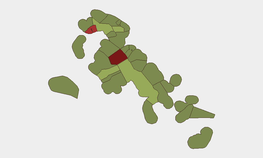
Situation Summary
The Bahamas remains at composite threat rank #85 globally, with crime and gang activity as the primary driver. No discrete security events were recorded in the country during the reporting period, though isolated violent incidents continue to affect New Providence. The U.S. State Department maintains a Level 2 travel advisory (Exercise Increased Caution), reflecting persistent crime concerns concentrated in Nassau and Freeport; the threat environment shows no material change week-on-week.
Key Developments
- Nassau, New Providence — September 17: A 22-year-old male was hospitalized following a shooting incident outside a residence on Wilton Street; two armed assailants opened fire on a group at the location. This incident aligns with the historical pattern of gang-related and interpersonal violence in the capital.
- Great Stirrup Cay, Berry Islands — September 16: A 52-year-old American passenger was pronounced dead aboard a cruise ship docked at Great Stirrup Cay. Police treated the death as an apparent suicide; no foul play was indicated.
- U.S. State Department Travel Advisory — September 17: The Department of State reaffirmed its Level 2 advisory for the Bahamas, identifying crime as the principal concern and designating Nassau (particularly the Over-the-Hill district) and Freeport as higher-risk zones. The advisory reflects an ongoing assessment, not a change in status during the reporting week.
- Canada and UK Travel Guidance — September 15–20: Official travel advisories from Canada and the United Kingdom continued to recommend heightened caution in the Bahamas due to crime, with specific emphasis on Nassau and Freeport. These reflect standing guidance rather than new incident-driven updates.
- Cyberattack Trend Warning — September 18: The Tribune published analysis of a 230% increase in cyberattacks against Bahamian businesses over the preceding five years, representing accumulated trend intelligence rather than a discrete incident in the current reporting window.
Highest-Risk Areas
New Providence (risk 92) and the City of Freeport (risk 78) dominate the sub-national threat landscape and account for the majority of national security concern. Both jurisdictions are characterized by gang-related violence, street crime, and organized criminal activity; New Providence, home to Nassau, carries particular weight owing to population density and economic significance. Central Abaco (risk 52) and Central Andros (risk 48) represent secondary risk nodes, likely reflecting resource constraints in law enforcement and geographic isolation that increase vulnerability to criminal organization. Security teams with personnel or assets in the capital or Freeport should apply elevated monitoring and protective protocols; outer islands present lower but non-negligible exposure.
How GeoBit Would Assist
Teams managing duty-of-care in the Bahamas would employ AOI Monitoring & Early Warning to maintain persistent watch on New Providence and Freeport, enabling rapid alerting on crime incidents, civil unrest, or security disruptions affecting corporate facilities or personnel. Risk & Threat Assessment capabilities support continuous evaluation of crime trends and geographic risk gradients, informing staffing decisions, travel policies, and security posture. OSINT fusion and multi-language search (including Telegram and local news feeds) allow systematic collection and corroboration of emerging incidents to validate intelligence before operational response.
7-Day Outlook
No material escalation in the threat environment is anticipated over the next seven days. Gang violence and street crime will likely persist at baseline levels in New Providence and Freeport, with sporadic incidents consistent with historical patterns. Continued adherence to State Department guidance and localized security protocols remains the standard risk-mitigation posture for organizations operating in the country.
Highest-Risk Areas — Ranked
| # | State / Region | Risk |
|---|---|---|
| 1 | New Providence | 92 |
| 2 | City of Freeport | 78 |
| 3 | Central Abaco | 52 |
| 4 | Central Andros | 48 |
| 5 | Exuma | 45 |
| 6 | East Grand Bahama | 42 |
| 7 | South Andros | 38 |
| 8 | North Abaco | 35 |
| 9 | North Eleuthera | 33 |
| 10 | South Abaco | 32 |
| 11 | Cat Island | 30 |
| 12 | Mangrove Cay | 28 |
Sources
Previous Weekly Briefs
A new Bahamas brief is written every Monday, covering the week — each with its own risk map and downloadable CSV. Use the calendar to go further back.
- September 15, 2026
- September 8, 2026
- September 2, 2026
- August 31, 2026
- August 29, 2026
- August 27, 2026
- August 25, 2026
📅 Browse past briefs by calendar →
Highlighted days have a brief. Tap a day for that day's map & analysis, or “csv” for that day's dataset ($5).
Atlas — our AI intelligence desk — emails them this snapshot personally. Nothing else, no list.