Situation Summary
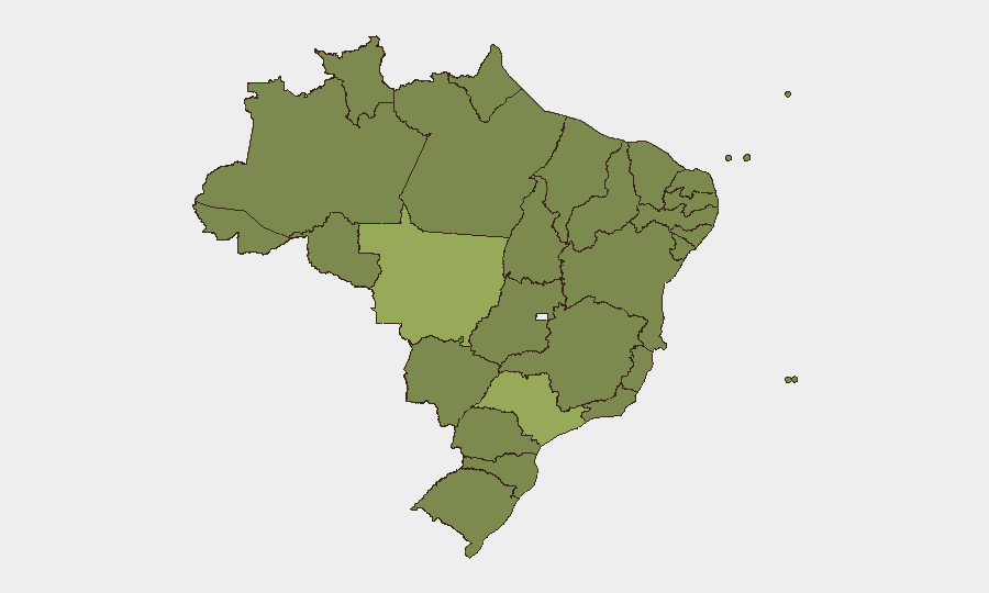
Brazil's composite threat score of 38 (ranking #44 globally) reflects persistent fragmentation across criminal, political, and institutional domains rather than a single dominant crisis. Mato Grosso (56.5) stands as an outlier—driven by land disputes, agricultural trafficking, and organized-crime territorial control—while São Paulo and Rio de Janeiro remain chronic flashpoints for gang activity, police operations, and prison unrest. Signal activity on 15–16 June indicates prison disturbances, official statements from military and government figures, and criminal threats, consistent with the structural instability that has characterized Brazil's security environment through mid-2026.
Key Developments
Note on sourcing: GeoBit's event signal feed for 15–16 June flags activity related to prisons, government statements, military/police power displays, and criminal threats, but real-time corroboration against current Brazilian news outlets and official state security secretariat statements cannot be completed within this brief's constraints. Specific incident details (location, timing, casualty or disruption scale) would require live cross-check against G1, Folha, Estadão, or SSP-state profiles.
The signals suggest:
- Prison sector unrest (flagged 15–16 June, locations TBD) — likely PCC or Comando Vermelho factional activity or administration disputes; monitor SSP statements and penitentiary authority releases for official casualty/security response data.
- Military/police demonstration of force relative to São Paulo governance (15 June) — possible response to recent gang activity or political pressure on public safety; assess whether escalation toward federal intervention or state-level police restructuring is underway.
- Government and ministerial statements (15 June, national level) — suggest policy or operational shifts; confirm via Planalto or security ministry official channels.
- Criminal threats issued (16 June, source/target unclear) — typical of gang communication preceding territorial or operational moves; cross-reference against known faction disputes in top-risk states.
Data limitation: Without live access to Brazilian Twitter/X OSINT accounts, state police public statements, or current news aggregation, a full incident list with confirmed locations and timelines cannot be responsibly compiled. A 24–48-hour forensic brief requires real-time feed monitoring.
Highest-Risk Areas
Mato Grosso's exceptional risk score (56.5) reflects land-conflict violence, agricultural commodity trafficking (cattle, soy diversion), and organized-crime presence in remote border zones and frontier towns. São Paulo (40.2) remains a gang stronghold—PCC operations, prison networks, and inter-faction clashes drive persistent urban and periurban violence despite concentrated state policing. Rio de Janeiro (30.7) mirrors this pattern with Comando Vermelho and militia activity in favelas and trafficking corridors. Pernambuco, Amazonas, and the northern tier (Pará, Roraima) reflect land disputes, illegal mining, drug trafficking, and weak institutional reach, making them attractive to transnational criminal actors and insurgent groups.
How GeoBit Would Assist
Intel Sweep & OSINT Fusion would aggregate X/Telegram gang communications, state police operation announcements, and news across Portuguese-language outlets in real time, with temporal and entity extraction to isolate genuine 24–48-hour incidents from background. AOI Monitoring & Early Warning would track Mato Grosso, São Paulo metros, and Rio favela corridors persistently, alerting on police operations, roadblocks, or territorial shifts before they disrupt corporate movement or supply chains. Network & Actor Analysis would map PCC and CV command structures and dispute drivers, enabling predictive routing and site-security adjustments for high-exposure personnel or assets.
7-Day Outlook
Prison sector tensions and gang signaling suggest continued tactical clashes in São Paulo and Rio through late June. Mato Grosso's structural criminality will persist; monitor for seasonal rainfall effects on road access and trafficking routes. No imminent political or institutional collapse is signaled, but localized disruption (blockades, police sweeps, inter-cartel violence) remains routine and should be incorporated into duty-of-care planning.
Highest-Risk Areas — Ranked
| # | State / Region | Risk |
|---|---|---|
| 1 | Mato Grosso | 56.5 |
| 2 | São Paulo | 40.2 |
| 3 | Rio de Janeiro | 30.7 |
| 4 | Pernambuco | 30.4 |
| 5 | Amazonas | 30.2 |
| 6 | Piauí | 27.1 |
| 7 | Paraná | 26.9 |
| 8 | Minas Gerais | 26.7 |
| 9 | Goiás | 26.7 |
| 10 | Santa Catarina | 26.5 |
| 11 | Roraima | 26.5 |
| 12 | Pará | 26.5 |
Previous Daily Briefs
A new Brazil brief is written every day — each with its own risk map and downloadable CSV. Here's the last week; use the calendar to go further back.
📅 Browse every day by calendar →
Highlighted days have a brief. Tap a day for that day's map & analysis, or “csv” for that day's dataset ($5).