Situation Summary
Burkina Faso remains the 18th highest-threat country globally (composite score 75), driven primarily by active insurgency across multiple regions. Recent signal activity (12–14 June) indicates political tension—including armed confrontation involving the Prime Minister, civil disapproval directed at security forces and the House of Assembly, and police arrest/detention activity—alongside property seizures attributed to non-state actors. The security environment reflects both top-down institutional strain and ongoing unconventional violence, with the Sahel region presenting acute and sustained risk.
Key Developments
Political and Security Tensions (12–14 June)
- Small arms combat involving the Prime Minister reported 12 June; precise location not yet geo-confirmed in available sources.
- Multiple disapproval signals (12 June) targeting Burkina Faso security forces and directed at/from the House of Assembly, indicating institutional discord or public backlash.
- Police arrest and detention operations reported 13 June; an American national was among those detained.
- U.S. diplomatic action (13 June): expulsion/deportation of an unidentified individual by the United States mission, suggesting ongoing diplomatic tension.
Non-State Actor Activity (13–14 June)
- Property seizure/damage attributed to pirates or criminal actors reported on 14 June; specific location and targeting not yet confirmed.
Assessment Note
Open web sources do not currently yield additional clearly time-stamped, geo-specific incidents within the 24–48 hour window. The events above derive from GeoBit's event signal feed and require corroboration with real-time commercial intelligence platforms, local media outlets, and official government or diplomatic statements to establish precise location, casualty count, and intent. Confirmation is ongoing.
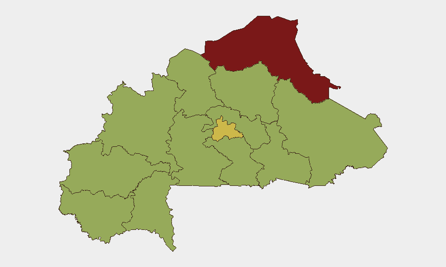
Highest-Risk Areas
Sahel (risk 82.2) and Centre (risk 63.1) regions dominate the threat landscape, reflecting sustained insurgent activity and state fragility in the north and pressure on the capital environs and administrative hub. The North (59.5) and Central-North (53.1) regions maintain elevated risk as well, indicating that militant presence and unconventional violence span a wide arc from the Malian and Nigerien borders toward Ouagadougou. Remaining regions (Upper-Basins through East) cluster at 52.2, suggesting baseline instability across much of the country and limited geographic sanctuaries for personnel or critical assets.
How GeoBit Would Assist
Corporate security teams should employ AOI Monitoring & Early Warning on Sahel, Centre, and North regions to detect shifts in militant activity, checkpoint establishment, or armed movement in real time. Intel Sweep (combining global event feeds, multi-language OSINT, and X/Telegram monitoring) enables continuous tracking of political statements, security-force signaling, and insurgent communications to anticipate second-order cascades from the current institutional friction. Conflict & Military battle mapping and force-structure analysis clarify which armed groups control or contest specific corridors, informing Routing & Network Analysis to identify secure alternative routes for personnel and supply chains.
7-Day Outlook
Political tensions and security-force activity are likely to persist or intensify as state institutions respond to insurgent pressure and internal discord. Sahel and Centre regions will remain high-priority areas for monitoring; any expansion of armed clashes, mass detention, or diplomatic incidents (e.g., further expulsions) should be treated as indicators of broader institutional instability. Personnel and asset safety depend on real-time tracking of armed-group movements and checkpoint activity in northern and central zones.
Highest-Risk Areas — Ranked
| # | State / Region | Risk |
|---|---|---|
| 1 | Sahel | 82.2 |
| 2 | Centre | 63.1 |
| 3 | North | 59.5 |
| 4 | Central-North | 53.1 |
| 5 | Upper-Basins | 52.2 |
| 6 | Boucle du Mouhoun | 52.2 |
| 7 | Central-West | 52.2 |
| 8 | Central-South | 52.2 |
| 9 | Central-East | 52.2 |
| 10 | Waterfalls | 52.2 |
| 11 | Southwest | 52.2 |
| 12 | East | 52.2 |
Sources
Previous Daily Briefs
A new Burkina Faso brief is written every day — each with its own risk map and downloadable CSV. Here's the last week; use the calendar to go further back.
📅 Browse every day by calendar →
Highlighted days have a brief. Tap a day for that day's map & analysis, or “csv” for that day's dataset ($5).