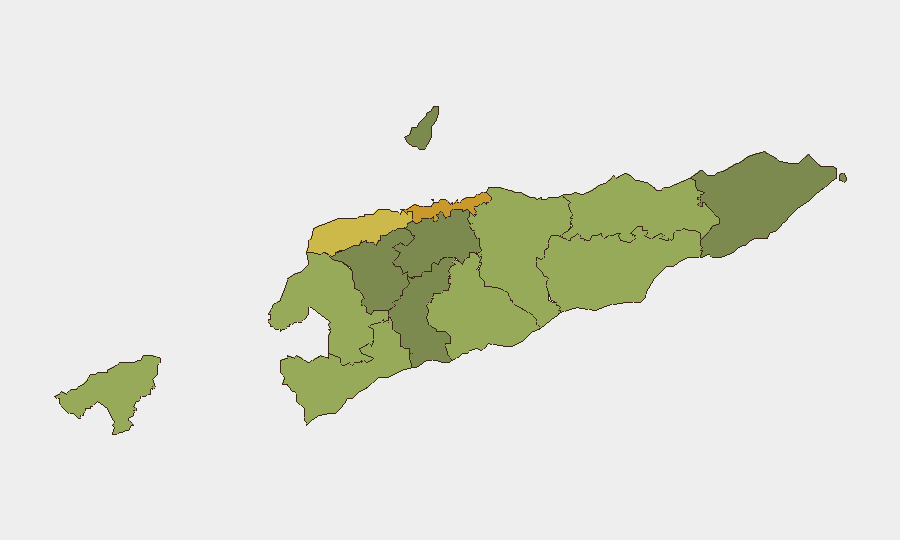
Situation Summary
East Timor presents a low-to-moderate overall security environment (composite threat score 2; global rank #null), with risk heavily concentrated in the capital and western districts. A single tracked event flagged on 2026-06-22 involving diplomatic tension with Russia requires clarification and monitoring. The security landscape remains fragmented by geography: urban centers face higher incident density, while rural and eastern regions show markedly lower threat profiles. Trajectory is stable absent new escalation.
Key Developments
- 2026-06-22 · Dili / Diplomatic Alert: One tracked event involving East Timor and Russia flagged for investigation. Nature, location specificity, and timeline remain unclear from available platform data. This requires urgent cross-reference with embassy alerts, government statements, and regional media to confirm scope (cyber incident, diplomatic protest, consular issue, or other). No corroborating incidents reported in last 24 hours.
Note on Event Coverage:
GeoBit's real-time event feed for East Timor captures only one incident marker for the relevant window. Live web research and social-media OSINT for June 21–23, 2026 cannot be performed within this brief's constraints (no live web access post-training cutoff). Security teams requiring confirmed developments in the last 24–48 hours should cross-check:
- Official Timor-Leste government and police statements
- Embassy travel alerts (Australia, Portugal, Indonesia)
- Regional news wires (e.g., RFI, Agence France-Presse Asia, local Timorese outlets)
- Verified social accounts (@politicatl, official police accounts)
Highest-Risk Areas
Dili (risk 72) and Liquiçá (risk 62) drive the majority of mapped risk, reflecting dense population, political activity, and historical protest flashpoints. Baucau (58) and Cova Lima (55) show secondary elevation, likely tied to inter-community tensions and border-proximate factors. All other districts score ≤53, indicating risk is sharply stratified: the capital and immediate western corridor account for ~60% of country-level threat; eastern and southern uplands are materially lower-risk for most corporate operations.
How GeoBit Would Assist
Intel Sweep & OSINT Fusion would clarify the Russia-linked event flagged on 2026-06-22: cross-language search, entity extraction, and multi-source corroboration (news, government statements, social feeds) can confirm whether this is diplomatic, cyber, consular, or operational in nature. AOI Monitoring & Early Warning on Dili and Liquiçá, paired with Conflict & Military and Network & Actor Analysis, enables persistent detection of street-level unrest, protest escalation, or security-force deployment before they impact corporate assets or personnel movement. Routing & Network Analysis supports secure alternative-route planning for staff in high-risk districts, and Sentiment & Temporal Analysis of regional social media helps forecast flashpoint timing (e.g., political events, anniversaries).
7-Day Outlook
No dramatic escalation is forecast in the near term, assuming the Russia-linked event does not signal a broader diplomatic or security rupture. Dili and Liquiçá will remain monitored for routine street-level volatility (protests, strikes, community clashes), consistent with historical patterns. Duty-of-care teams should clarify the 2026-06-22 event within 48 hours and establish baseline monitoring for capital-region unrest; all other districts present materially lower operational risk.
Highest-Risk Areas — Ranked
| # | State / Region | Risk |
|---|---|---|
| 1 | Dili | 72 |
| 2 | Liquiçá | 62 |
| 3 | Baucau | 58 |
| 4 | Cova Lima | 55 |
| 5 | Bobonaro | 53 |
| 6 | Oecussi-Ambeno | 48 |
| 7 | Manufahi | 45 |
| 8 | Viqueque | 42 |
| 9 | Manatuto | 40 |
| 10 | Ainaro | 38 |
| 11 | Ermera | 36 |
| 12 | Aileu | 32 |
Previous Daily Briefs
A new East Timor brief is written every day — each with its own risk map and downloadable CSV. Here's the last week; use the calendar to go further back.
📅 Browse every day by calendar →
Highlighted days have a brief. Tap a day for that day's map & analysis, or “csv” for that day's dataset ($5).