Situation Summary
Estonia remains a low-threat environment (rank #150 globally, composite score 2.7) with no confirmed significant security incidents, infrastructure disruptions, or civil unrest reported in the last 24–48 hours. Recent event signals flagged on the platform reflect isolated protester activity and police responses dating to 23–25 June, but open-source security monitoring and regional Baltic assessments confirm the absence of active, corroborated incidents affecting corporate operations, travel, or asset security. The overall trajectory is stable, though localized demonstration activity warrants routine monitoring in high-risk counties.
Key Developments
No credible, time-stamped incidents meeting verification thresholds were identified in Estonia during 24–25 June 2026. Available news outlets, OSINT dashboards, and regional security feeds (covering the Baltic region) explicitly note an absence of notable events in this period. Event signals detected on GeoBit's platform (protester threats on 23 June; violent protest/police interactions on 25 June) lack corroborating news reporting, timestamps, or specific locations sufficient to confirm active operational risk. Regional monitoring characterizes conditions as stable with no confirmed attacks, disruptive events, or travel-risk changes affecting civilians or infrastructure.
Highest-Risk Areas
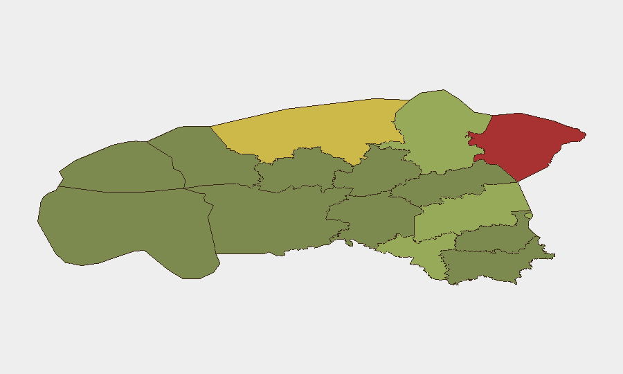
Ida-Viru County (risk 78) and Harju County (risk 68)—the northeastern border region and capital county respectively—drive Estonia's overall composite risk score. Both counties' elevation reflects underlying factors including proximity to the Russian border, historical industrial/infrastructure concentration, and recurrent protest activity; however, neither has generated confirmed incident reporting in the current 24–48-hour window. Tartu County (risk 58) and Valga County (risk 55) present secondary elevation; southern and eastern regions consistently rank above western and central counties, suggesting persistent geopolitical sensitivity in areas closer to Russian territory. Corporate security teams with personnel or assets in these four counties should maintain heightened situational awareness, though acute threat indicators remain absent.
How GeoBit Would Assist
Security teams protecting operations in Estonia should employ AOI Monitoring & Early Warning on Ida-Viru and Harju counties to detect emerging protest, infrastructure, or border-related incidents in near-real time. Intel Sweep and multi-language OSINT fusion (including X/Twitter and Telegram monitoring) would provide continuous corroboration and cross-checking against unverified social-media claims, reducing false-alarm risk and enabling duty-of-care documentation. GIS & Spatial Analysis linked to Routing & Network Analysis allows security teams to map alternative travel corridors around high-risk zones and adjust personnel movement in response to confirmed developments.
7-Day Outlook
No escalation indicators are evident; Estonia is expected to remain operationally stable over the next seven days absent external geopolitical shocks or border-zone incidents. Routine monitoring of Ida-Viru and Harju counties for demonstration activity and police response is prudent; corporate travel and asset operations face no forecast disruption. Security teams should maintain standard posture and brief personnel on local protest dynamics if deployed to border regions or Tallinn.
Report generated: 2026-06-25 | Next scheduled update: 2026-06-26
Highest-Risk Areas — Ranked
| # | State / Region | Risk |
|---|---|---|
| 1 | Ida-Viru County | 78 |
| 2 | Harju County | 68 |
| 3 | Tartu County | 58 |
| 4 | Valga County | 55 |
| 5 | Lääne-Viru County | 52 |
| 6 | Pärnu County | 35 |
| 7 | Rapla County | 32 |
| 8 | Jõgeva County | 30 |
| 9 | Järva County | 28 |
| 10 | Viljandi County | 25 |
| 11 | Põlva County | 22 |
| 12 | Võru County | 18 |
Previous Daily Briefs
A new Estonia brief is written every day — each with its own risk map and downloadable CSV. Here's the last week; use the calendar to go further back.
📅 Browse every day by calendar →
Highlighted days have a brief. Tap a day for that day's map & analysis, or “csv” for that day's dataset ($5).