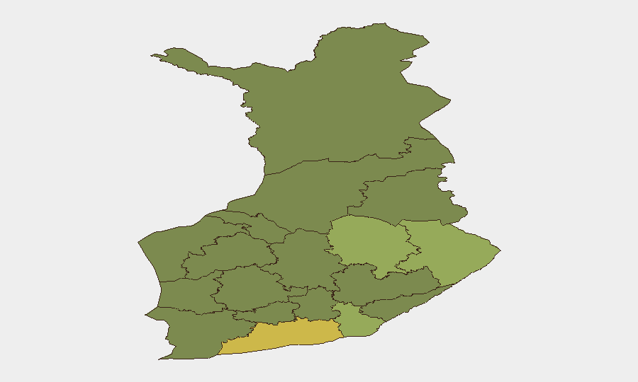
Situation Summary
Finland maintains a low composite threat score (6/141 globally) with no tracked security incidents at the national level as of 2026-08-08. A temporary air and maritime traffic restriction in the eastern Gulf of Finland on 2026-08-05 was precautionary and resolved without incident. Overall security posture remains stable; however, sub-national risk concentration in Uusimaa and eastern border regions warrants localized attention from organizations with distributed assets.
Key Developments
- Eastern Gulf of Finland — 2026-08-05, 05:26–07:13 UTC — Finnish Defence Forces imposed temporary restrictions on air and maritime traffic following reports of possible drone activity in proximity to the Russian border near St. Petersburg; no drones entered Finnish airspace, and restrictions were lifted without escalation after two hours.
- Mannerheimintie, central Helsinki — 2026-08-03 — A stabbing incident occurred in the downtown nightlife district; a young male sustained a stab wound, and police apprehended a suspect at the scene. (Single-source report; incident assessed as localized criminal violence, not organized or systematic.)
- Kuopio region — 2026-08-05 — A fatal motorcycle accident on Alapitkntie road killed a 25-year-old female operator; road conditions cited as contributing factor. (Transportation incident, not security-related.)
Highest-Risk Areas
Uusimaa (composite risk 65) dominates the national sub-national ranking and encompasses the capital region (Helsinki, Espoo, Vantaa) and surrounding metropolitan area. The elevated score reflects concentration of population, economic activity, and infrastructure—standard for capital regions—rather than acute conflict or organized crime networks. Eastern regions including North Karelia (44), Kymenlaakso (42), and North Savo (40) show elevated risk scores, primarily driven by proximity to the Russian border and historical cross-border trafficking patterns. Risk in these areas is chronic rather than acute; the 2026-08-05 airspace restriction did not signal a new threat trajectory but reflects routine operational security monitoring common along NATO borders.
How GeoBit Would Assist
Organizations with personnel or assets in Finland, particularly in Uusimaa or eastern border regions, should deploy AOI Monitoring & Early Warning on Uusimaa, North Karelia, and Kymenlaakso to detect spikes in cross-border activity, infrastructure disruptions, or civil unrest. Intel Sweep and multi-language OSINT (including X/Twitter and local Finnish police/defence feeds) enable real-time tracking of border incidents, aviation restrictions, and crime-pattern shifts affecting duty-of-care compliance. Routing & Network Analysis supports contingency planning for personnel transiting the Helsinki metro area or eastern corridors, with alternative routes identified before disruption occurs.
7-Day Outlook
No material escalation is expected in the near term. The temporary airspace restriction on 2026-08-05 appears to have been a precautionary response to isolated eastern-border activity; routine Finnish Defence Forces monitoring will likely continue without further public restrictions. Organizations should maintain baseline situational awareness in Uusimaa and maintain contact with local in-country teams to confirm any personnel safety impacts from routine police or border operations.
Highest-Risk Areas — Ranked
| # | State / Region | Risk |
|---|---|---|
| 1 | Uusimaa | 65 |
| 2 | North Karelia | 44 |
| 3 | Kymenlaakso | 42 |
| 4 | North Savo | 40 |
| 5 | South Karelia | 38 |
| 6 | Kainuu | 36 |
| 7 | Päijät-Häme | 35 |
| 8 | South Savo | 32 |
| 9 | Kanta-Häme | 30 |
| 10 | Pirkanmaa | 28 |
| 11 | Central Finland | 26 |
| 12 | Southwest Finland | 25 |
Sources
Previous Daily Briefs
A new Finland brief is written every day — each with its own risk map and downloadable CSV. Here's the last week; use the calendar to go further back.
📅 Browse every day by calendar →
Highlighted days have a brief. Tap a day for that day's map & analysis, or “csv” for that day's dataset ($5).
Atlas — our AI intelligence desk — emails them this snapshot personally. Nothing else, no list.