Situation Summary
Guinea-Bissau remains a low-frequency security environment (global rank #54) with no reported acute incidents in the past 48 hours. Underlying structural risks—political fragility, weak state capacity, and organized crime—persist at baseline levels across the country. The absence of recent event reporting reflects the country's general position outside current major conflict or crisis zones, though sub-national variations in risk are substantial.
Key Developments
Open-source monitoring (news wires, conflict-mapping platforms, and social-media intelligence) has not identified credible, geolocated, time-stamped security incidents in Guinea-Bissau during 2–4 July 2026. Routine political, economic, and social activity continues without reported disruption to travel, commerce, or critical services. Risk assessment remains anchored to longer-term vulnerabilities rather than acute triggering events in this reporting window.
Highest-Risk Areas
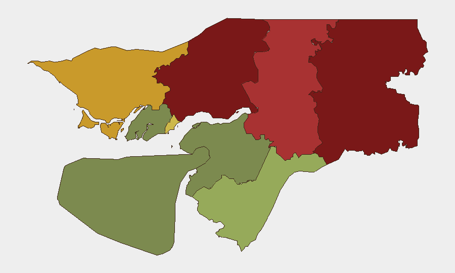
Gabu Region (risk 92) and Oio Region (risk 85) dominate the sub-national threat profile, followed by Bafatá and Cacheu regions (78 and 72, respectively). These border and northern areas typically exhibit elevated vulnerability to cross-border trafficking, weak law-enforcement presence, and historical political tension. Bissau Autonomous Sector (68) reflects capital-city crime and occasional civic instability, while southern regions—Tombali, Quinara, and Biombo—carry substantially lower composite scores (45, 38, and 32). Northern concentration of risk reflects Guinea-Bissau's geography: proximity to Senegal and Guinea, porous borders, and limited state administration.
How GeoBit Would Assist
Teams with personnel or assets in high-risk zones (Gabu, Oio, Bafatá, Cacheu) should deploy Area-of-Interest Monitoring & Early Warning on key facilities, borders, and transit routes to detect emerging unrest or crime spikes in near-real time. Intel Sweep (global event feeds, OSINT fusion, multi-language search) and Conflict & Military network analysis enable continuous baseline tracking of political actors, armed groups, and smuggling networks that drive the country's structural risk. Routing & Network Analysis can identify safer transit corridors and alternative supply chains, particularly for movement across the northern regions where road security and infrastructure remain unpredictable.
7-Day Outlook
No indicators suggest acute deterioration over the next week. Guinea-Bissau's trajectory remains shaped by incremental political and institutional challenges rather than imminent conflict or major unrest. Teams should maintain routine vigilance on northern border activity and capital-city crime reporting; any shift in regional political dynamics (Senegal, Guinea) may have secondary effects on Guinea-Bissau's stability.
Report Date: 2026-07-04
Data Window: 2026-07-02 to 2026-07-04
Next Update: 2026-07-05
Highest-Risk Areas — Ranked
| # | State / Region | Risk |
|---|---|---|
| 1 | Gabu Region | 92 |
| 2 | Oio Region | 85 |
| 3 | Bafatá Region | 78 |
| 4 | Cacheu Region | 72 |
| 5 | Bissau Autonomous Sector | 68 |
| 6 | Tombali Region | 45 |
| 7 | Quinara Region | 38 |
| 8 | Biombo Region | 32 |
| 9 | Bolama Region | 15 |
Previous Daily Briefs
A new Guinea-Bissau brief is written every day — each with its own risk map and downloadable CSV. Here's the last week; use the calendar to go further back.
📅 Browse every day by calendar →
Highlighted days have a brief. Tap a day for that day's map & analysis, or “csv” for that day's dataset ($5).
Atlas — our AI intelligence desk — emails them this snapshot personally. Nothing else, no list.