Situation Summary
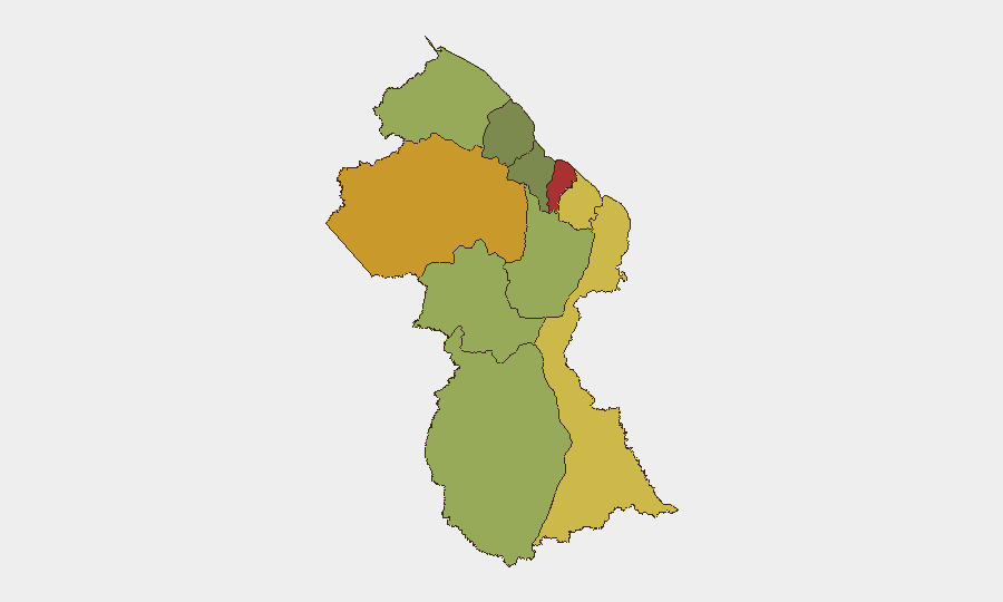
Guyana's security environment remains stable with no major corroborated incidents reported in the last 24–48 hours. The country's overall composite threat score of 18 places it outside the global top-tier risk zone, though sub-national variation is material: Demerara-Mahaica and Cuyuni-Mazaruni regions carry substantially elevated risk profiles (78 and 72 respectively) relative to the national baseline. Current reporting is dominated by diplomatic positioning at the UN rather than domestic instability, indicating no acute deterioration in-country.
Key Developments
No new security, civil-unrest, crime, or infrastructure incidents with corroborated timestamps within the last 24–48 hours have been identified in open reporting.
Background note (for context, not current development): Older crime and road-safety incidents from the Corentyne and Linden regions continue to circulate in news feeds, but these are archival (pre-dating the current 24–48 hour window) and do not represent fresh events.
Diplomatic activity has centered on UN engagement in New York (June 18–19), where Guyana's UN ambassador advanced a candidacy for UN Secretary-General on conflict-resolution platforms—a positioning effort that reflects Guyanese soft-power ambition and does not signal domestic security deterioration.
Highest-Risk Areas
Demerara-Mahaica (risk 78) and Cuyuni-Mazaruni (risk 72) account for the largest differential risk burden, with Mahaica-Berbice (65) and East Berbice-Corentyne (62) following. These four regions collectively drive the country's risk profile. Demerara-Mahaica encompasses Georgetown and the coastal corridor where population density, economic activity, and historical crime concentration are highest; Cuyuni-Mazaruni's elevation reflects its interior location, limited state presence, and historical association with cross-border trafficking and informal mining activity. Organizations with personnel or assets concentrated in the coastal zone should prioritize these two regions in duty-of-care planning. The remaining eight regions show lower but non-negligible risk, with Essequibo Islands (35) at the baseline.
How GeoBit Would Assist
Security and risk teams operating in Guyana should activate AOI Monitoring & Early Warning on Demerara-Mahaica, Cuyuni-Mazaruni, and East Berbice-Corentyne to detect emerging incidents with persistent watch and automated alerting; deploy Intel Sweep and multi-language OSINT (including X/Telegram and local news feeds) to maintain awareness of crime, unrest, and border-security developments; and use Routing & Network Analysis to develop alternative travel routes and safe-passage protocols for personnel moving between Georgetown, interior mining/resource sites, and border zones. Periodic Satellite & Imagery analysis of high-risk corridors can supplement human intelligence and provide non-attributable verification of reported events.
7-Day Outlook
No indicators of near-term escalation in crime, political unrest, or infrastructure disruption are visible in current open reporting. Risk trajectory remains stable at baseline levels. Continued monitoring of Demerara-Mahaica and Cuyuni-Mazaruni is warranted as standard practice; no surge in alerting is anticipated unless corroborated reporting emerges of localized incidents, border tensions, or large-scale protest activity.
Highest-Risk Areas — Ranked
| # | State / Region | Risk |
|---|---|---|
| 1 | Demerara-Mahaica | 78 |
| 2 | Cuyuni-Mazaruni | 72 |
| 3 | Mahaica-Berbice | 65 |
| 4 | East Berbice-Corentyne | 62 |
| 5 | Upper Demerara-Berbice | 58 |
| 6 | Potaro-Siparuni | 48 |
| 7 | Barima-Waini | 45 |
| 8 | Upper Takutu-Upper Essequibo | 42 |
| 9 | Pomeroon-Supenaam | 38 |
| 10 | Essequibo Islands | 35 |
Sources
Previous Daily Briefs
A new Guyana brief is written every day — each with its own risk map and downloadable CSV. Here's the last week; use the calendar to go further back.
📅 Browse every day by calendar →
Highlighted days have a brief. Tap a day for that day's map & analysis, or “csv” for that day's dataset ($5).