Situation Summary
Ivory Coast remains a relatively stable operating environment (global rank #52, composite threat score 17) with no tracked major security incidents. However, acute weather-driven emergency and localized civil-order events in Abidjan and centre-east districts over the last 48 hours have created immediate hazards—particularly flash flooding, landslides, and traffic disruption—alongside ongoing low-level criminal enforcement activity. The northern and north-eastern savanna districts (Savanes, Zanzan, Denguélé) retain elevated structural risk, but near-term corporate exposure in urban areas centers on climate-related infrastructure and casualty risks.
Key Developments
- Abidjan (Attécoubé & Yopougon) – 31 July–1 August 2026: Intense rainfall triggered flash floods and landslides across multiple neighborhoods; local media report 10+ deaths including a family of 9 in Attécoubé and Yopougon. Authorities have issued warnings against using inundated routes, particularly Carrefour 09 Kilos, due to vehicle stranding and wash-off hazards.
- Abidjan (Attécoubé-Mossikro) – 31 July–1 August 2026: Hillside landslide in Mossikro caused structural collapse; emergency services on scene with ongoing risk of further ground movement. Civil-protection advisories urge residents in precarious housing on high-risk slopes to evacuate.
- Abidjan (Koumassi Campement) – reported 1 August 2026: Local figure Alloui Brou Jacques placed under detention order (*mandat de dépôt*) in connection with a contentious demolition operation; tension remains with affected residents.
- Centre-east Côte d'Ivoire (Ouellé, near Daoukro) – weekend 25–26 July, follow-up through late July: Following a fatal stabbing (24-year-old victim) in a sex-worker frequented site, youths sacked and burned local installations. Police and reinforcements from Daoukro deployed; situation now officially under control with investigation ongoing into homicide and vandalism.
- National – Police anti-narcotics operations ongoing: Enhanced anti-drug enforcement includes a major seizure in Assinie (8 July) and continued intensified police presence and controls through late July as part of broadened security posture.
Highest-Risk Areas
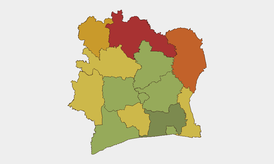
The northern and north-eastern districts—Savanes (78), Zanzan (75), and Denguélé (72)—drive Ivory Coast's sub-national risk profile, reflecting historical cross-border trafficking, limited state capacity, and structural instability in the Sahel region. The eastern and central interior districts (Comoé, Montagnes, Woroba) similarly score elevated risk (70, 68, 65 respectively), likely reflecting remote terrain, trafficking corridors, and sparse security infrastructure. Abidjan (45) and the southern/central coastal and plantation zones remain substantially lower-risk, though the current flooding event underscores vulnerability to non-security environmental shocks that can strain local emergency response and disrupt supply chains.
How GeoBit Would Assist
Security teams with personnel or assets in Ivory Coast should deploy AOI (Area-of-Interest) Monitoring & Early Warning on high-risk northern districts and key urban nodes (Abidjan, Yamoussoukro) to track emerging civil unrest, trafficking activity, or political instability with alerting. Environmental & Health monitoring, combined with Routing & Network Analysis, enables real-time tracking of climate hazards (flooding, landslides) and rapid alternative-route planning for supply and personnel movement. OSINT fusion and multi-language search (X, Telegram, Ivorian news outlets) provide continuous corroboration of local incident reporting and early warning of civil-order deterioration.
7-Day Outlook
Immediate flooding risk in Abidjan will likely subside as rainfall patterns normalize, but secondary effects (infrastructure damage, public-health concern, localized displacement) may persist into early next week. Northern districts will continue to warrant standard vigilance on trafficking and cross-border movement. No major escalation in political or security-force dynamics is anticipated in the near term.
Highest-Risk Areas — Ranked
| # | State / Region | Risk |
|---|---|---|
| 1 | Savanes District | 78 |
| 2 | Zanzan District | 75 |
| 3 | Denguélé District | 72 |
| 4 | Comoé District | 70 |
| 5 | Montagnes District | 68 |
| 6 | Woroba District | 65 |
| 7 | Gôh-Djiboua District | 60 |
| 8 | Sassandra-Marahoué District | 58 |
| 9 | Vallée du Bandama District | 55 |
| 10 | Bas-Sassandra District | 52 |
| 11 | Lacs District | 48 |
| 12 | Abidjan | 45 |
Sources
Previous Daily Briefs
A new Ivory Coast brief is written every day — each with its own risk map and downloadable CSV. Here's the last week; use the calendar to go further back.
📅 Browse every day by calendar →
Highlighted days have a brief. Tap a day for that day's map & analysis, or “csv” for that day's dataset ($5).
Atlas — our AI intelligence desk — emails them this snapshot personally. Nothing else, no list.