Situation Summary
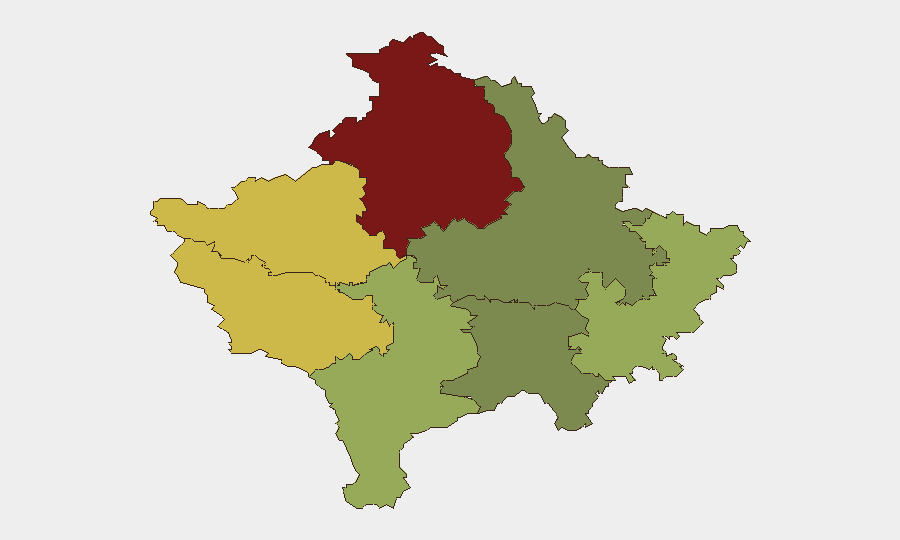
Kosovo remains at low global risk (#118 globally; composite threat score 13) with no tracked discrete security events in the current reporting window. However, a cross-border incendiary attack launched from Kosovo into central Serbia on the night of 22–23 August 2026, combined with ongoing political friction over the Mitrovica Ibar River bridge and unresolved tensions tied to 2023 civil unrest, has elevated localized threat perception in northern Kosovo and along the Serbia–Kosovo border. The sub-national risk profile is heavily skewed toward Mitrovica district (risk score 92), where ethnic-Serbian enclaves, disputed infrastructure, and NATO/Kosovo Police transitions remain flashpoints.
Key Developments
- Brnjak area, Serbia–Kosovo border (Night of 22–23 August 2026): A "fireball" incendiary device was reportedly launched from Kosovo territory toward central Serbia and recovered near Brnjak; though it did not ignite, the apparent intent was arson. This marks an escalation in cross-border hostile action and has raised immediate tension in the border region.
- Mitrovica Ibar River bridge (22 August 2026): Serbian President Vučić issued a formal letter warning that NATO/KFOR's withdrawal of Italian Carabinieri from the northern side and transition of control to Kosovo Police constitutes a "hotspot" risk for attacks on Serbs. NATO has committed to maintaining visible presence on both sides despite the reconfiguration.
- Mitrovica Ibar River bridge (22 August 2026): Kosovo Prime Minister Albin Kurti publicly demanded full opening of the main bridge, citing economic and security benefits from recent new crossings and reduced incidents. This political demand directly contradicts Serbian security concerns and signals continued gridlock on critical infrastructure control.
- North Mitrovica Regional Police Directorate (22 August 2026 public update): Kosovo's Police Inspectorate recommended suspension of two officers following investigation into allegations that a Kosovo Serb, Nenad Rasković, was beaten during a police raid in Dren, Zubin Potok municipality on 11 August 2026. The public recommendation underscores alleged police misconduct and deepens community grievances in the north.
- Zvečan detention (18 August 2026, reported through 23 August 2026): Pristina's Basic Court ordered 30 days pre-trial detention for a Zvečan Serb suspected of participating in violent attacks on KFOR and Kosovo Police during May 2023 civil unrest. Ongoing prosecutions of 2023 participants continue to fuel inter-ethnic tension.
- Zubin Potok weapons operations (16–17 August 2026, reported through 18 August 2026): Police raids yielded weapons, ammunition, and military equipment; an arrest was made linked to 2023 attacks against KFOR and Kosovo Police. These operations signal sustained law-enforcement pressure in northern enclaves.
Highest-Risk Areas
Mitrovica district dominates the risk profile (score 92), driven by ethnic division, disputed bridge infrastructure, contested policing authority, and ongoing allegations of abuse. Peja (68) and Gjakova (65) follow, reflecting broader tensions in western Kosovo near the Serbia–Montenegro border and among Serbian-majority communities. Prizren (55) and Gjilan (52) carry elevated risk tied to minority protections and historical grievance. Prishtina (28), by contrast, remains substantially lower-risk, suggesting capital-area stability masks concentrated northern volatility.
How GeoBit Would Assist
Security teams should deploy AOI Monitoring & Early Warning on Mitrovica district, the Ibar River bridge corridor, and the Serbia–Kosovo border to detect hostile action, protest activity, and police operations in real time. Multi-language OSINT (including Serbian, Albanian, and English media fusion) combined with Telegram & X OSINT would capture community sentiment, political rhetoric, and tactical signals ahead of escalation. Routing & Network Analysis can identify safe transit corridors and alternative crossings if primary infrastructure becomes contested.
7-Day Outlook
The cross-border incendiary attack and bridge-access dispute suggest a period of elevated political and tactical tension through late August, with risk of further tit-for-tat incidents or police operations in northern enclaves. Absent a major escalation or political breakthrough on bridge access, the risk is expected to remain localized to Mitrovica and adjacent districts; travel to central and southern Kosovo should remain broadly routine-risk.
Highest-Risk Areas — Ranked
| # | State / Region | Risk |
|---|---|---|
| 1 | District of Mitrovica | 92 |
| 2 | District of Peja | 68 |
| 3 | District of Gjakova | 65 |
| 4 | District of Prizren | 55 |
| 5 | District of Gjilan | 52 |
| 6 | District of Ferizaj | 38 |
| 7 | District of Prishtina | 28 |
Sources
Previous Daily Briefs
A new Kosovo brief is written every day — each with its own risk map and downloadable CSV. Here's the last week; use the calendar to go further back.
- August 21, 2026
- August 19, 2026
- August 17, 2026
- August 15, 2026
- August 13, 2026
- August 11, 2026
- August 9, 2026
📅 Browse every day by calendar →
Highlighted days have a brief. Tap a day for that day's map & analysis, or “csv” for that day's dataset ($5).
Atlas — our AI intelligence desk — emails them this snapshot personally. Nothing else, no list.