Situation Summary
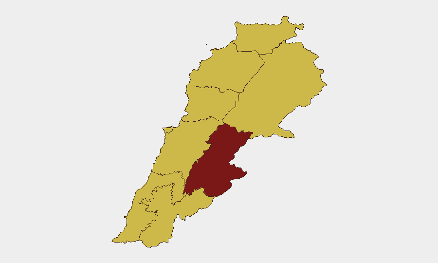
Lebanon remains in a critically volatile state as Israeli military operations and Hezbollah engagements continue despite a renewed ceasefire framework, with confirmed casualties mounting across southern and eastern regions. The Beqaa Governorate carries the highest composite risk (91.9), followed by the South Governorate (68.2), driven primarily by active military strikes and militia activity. The security trajectory remains fragile; while some displaced populations have begun returning to calmer zones, infrastructure damage is extensive and the operational environment is subject to rapid deterioration.
Key Developments
- Nabatieh district, southern Lebanon – 21 June 2026: Israel Defense Forces conducted airstrikes on multiple villages including Harou, Habous, and al-Dweir. Lebanon's Health Ministry reported 47 killed and 97 wounded; the IDF stated it struck approximately 80 Hezbollah sites and killed dozens of combatants.
- Southern Lebanon (unspecified border area) – 21 June 2026: Hezbollah fighters ambushed an Israeli military unit with guided munitions and rocket/artillery fire, reportedly destroying three vehicles and targeting accompanying personnel, occurring during the same operational window as heavy Israeli air activity.
- Southern and eastern Lebanon – night of 21–22 June 2026: The IDF conducted overnight strikes on more than 150 Hezbollah infrastructure sites and targets across southern and eastern Lebanon. Lebanese authorities confirmed at least 21 additional fatalities from these operations, continuing despite the ceasefire framework renewal.
- Israeli-occupied southern Lebanon – 21 June 2026: BBC field documentation confirmed extensive physical destruction in multiple villages, including collapsed structures and depopulated communities, corroborating widespread infrastructure damage in front-line areas.
- Southern Lebanon displacement zones – 21–22 June 2026: Limited numbers of displaced families have begun returning to parts of southern Lebanon following the ceasefire renewal, with partial reopening of roads and services in less-damaged areas; overall security remains fragile and many villages remain heavily damaged.
- Israel security zone policy – 22 June 2026: Israeli Prime Minister Benjamin Netanyahu reaffirmed maintenance of a "security zone" inside southern Lebanon "for as long as necessary," signaling continued Israeli military presence and associated operational risks in border-adjacent areas.
- Lebanon-wide travel advisory – updated 21–22 June 2026: Australian government and international travel advisories continue "Do not travel" ratings due to armed conflict, civil unrest, and terrorism, with explicit warnings of volatile conditions and potential rapid deterioration affecting commercial transport.
Highest-Risk Areas
The Beqaa Governorate and South Governorate drive the composite risk ranking, reflecting active military operations, militia presence, and infrastructure targeting across both regions. South Governorate's elevated risk (68.2) stems from direct Israeli-Hezbollah engagement, confirmed civilian casualties, and ongoing Israeli military occupation of border zones. Beirut Governorate and Mount Lebanon (both 66–65.2) face secondary but significant risk from potential spillover effects, displaced population movement, and militia activity. The concentration of threat in the eastern (Beqaa, Baalbek-Hermel) and southern zones reflects the geographic center of Israeli operations and Hezbollah staging.
How GeoBit Would Assist
Security teams monitoring Lebanon should deploy Area-of-Interest (AOI) Monitoring & Early Warning on the Beqaa and South Governorates to detect changes in strike patterns, displacement flows, and ceasefire violations in near-real-time. Battle Mapping and Force Structure tracking combined with OSINT fusion across social media, news feeds, and regional reporting would provide tactical awareness of Hezbollah and IDF posture changes. Routing & Network Analysis enables duty-of-care teams to model safe transit corridors and identify infrastructure choke points subject to ongoing targeting.
7-Day Outlook
The ceasefire framework remains under active strain, with both Israeli and Hezbollah operations continuing despite nominal truce terms. Expect further airstrikes on designated Hezbollah targets, particularly in the Beqaa and South, and continued Hezbollah counterattacks. Civilian return and humanitarian access will remain episodic and reversible, with security conditions capable of rapid deterioration if escalation resumes.
Highest-Risk Areas — Ranked
| # | State / Region | Risk |
|---|---|---|
| 1 | Beqaa Governorate | 91.9 |
| 2 | South Governorate | 68.2 |
| 3 | Beirut Governorate | 66 |
| 4 | Mount Lebanon Governorate | 65.2 |
| 5 | Nabatieh Governorate | 65.2 |
| 6 | Akkar Governorate | 62.4 |
| 7 | North Governorate | 61.9 |
| 8 | Keserwan-Jbeil Governorate | 61.9 |
| 9 | Baalbek-Hermel Governorate | 61.9 |
Sources
Previous Daily Briefs
A new Lebanon brief is written every day — each with its own risk map and downloadable CSV. Here's the last week; use the calendar to go further back.
📅 Browse every day by calendar →
Highlighted days have a brief. Tap a day for that day's map & analysis, or “csv” for that day's dataset ($5).