Situation Summary
Lesotho remains at low overall security risk (composite score 6; #null globally) with no tracked discrete incidents in the current window and no credible reports of civil unrest, armed conflict, or organized crime events in the last 24–48 hours. However, severe weather has disrupted cross-border infrastructure, and underlying sub-national risk concentration in Maseru District (78) and surrounding urban areas continues to drive national threat exposure. The security environment is stable but operationally constrained by climate factors and logistics disruption.
Key Developments
- Qacha's Nek Port of Entry, SA–Lesotho border – August 3, 2026
Heavy snowfall forced temporary closure of the Qacha's Nek Port of Entry; South Africa's Border Management Authority suspended operations on safety grounds. Travellers advised to delay non-essential crossings or divert via Telle Bridge (~190 km). This is a logistics and travel-risk disruption affecting cross-border movement and supply chains, not civil unrest.
- Nationwide early warning and preparedness campaign – late July / early August 2026 (ongoing)
Lesotho authorities launched a nationwide disaster preparedness and emergency response campaign ahead of severe weather season, expanding community training, early-warning systems, and inter-agency coordination. This reflects active state-led risk mitigation but also signals heightened climate vulnerability.
- No new civil unrest, crime, or political incidents reported in last 24–48 hours
Cross-checking of major regional outlets, Lesotho news sites, government sources, and social media feeds confirms no verified reports of protests, roadblocks, armed clashes, kidnappings, or high-profile crime events with timestamps in the current window.
Highest-Risk Areas
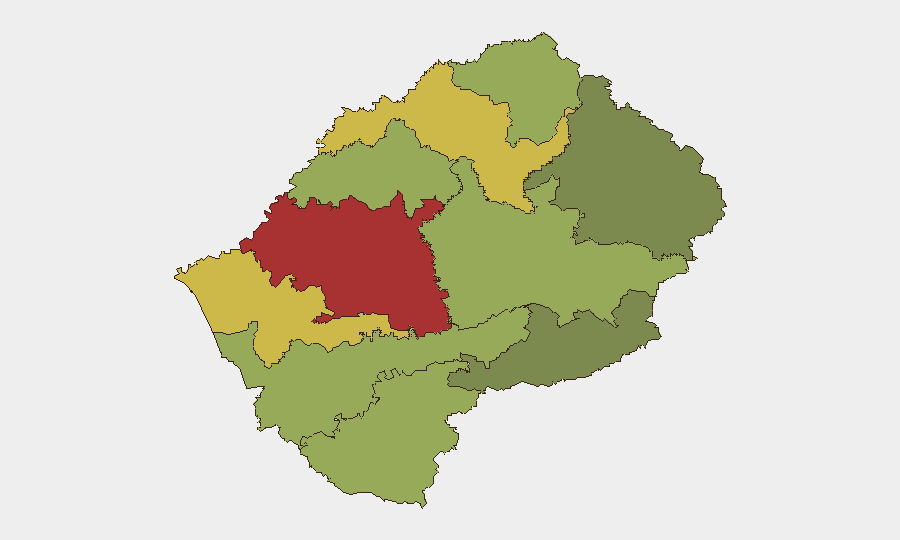
Maseru District (risk 78) remains the primary driver of national risk, followed by Mafeteng (65) and Leribe (62). Risk concentration in these urban and peri-urban zones reflects historical patterns of property crime, gang activity, and localized political tension. The capital and surrounding districts account for the majority of reported incidents and vulnerabilities; rural districts (Qacha's Nek, Mokhotlong) carry substantially lower composite scores. Corporate and expatriate exposure is highest in Maseru and should remain the focus of duty-of-care protocols.
How GeoBit Would Assist
Security teams should deploy Area-of-Interest (AOI) Monitoring & Early Warning focused on Maseru and Mafeteng districts to detect emerging civil unrest, crime clusters, or infrastructure failures with automated alerting. Intel Sweep and X/Twitter OSINT provide continuous real-time coverage of political sentiment, gang activity, and incident reporting across Lesotho's limited but active social media landscape. Routing & Network Analysis is operationally valuable for cross-border operations during weather closures, enabling advance identification of alternative transport corridors and logistics contingency planning.
7-Day Outlook
Severe weather is expected to persist through early August, with additional snow possible at higher elevations and border crossings; further temporary closures of Qacha's Nek or secondary crossing points are plausible. Civil unrest risk remains low, but logistics disruption and potential supply-chain delays should be factored into personnel and asset deployment timelines. Maseru District will continue to require elevated situational awareness for property-crime and localized safety concerns.
Highest-Risk Areas — Ranked
| # | State / Region | Risk |
|---|---|---|
| 1 | Maseru District | 78 |
| 2 | Mafeteng District | 65 |
| 3 | Leribe District | 62 |
| 4 | Berea District | 58 |
| 5 | Mohale's Hoek District | 52 |
| 6 | Butha-Buthe District | 48 |
| 7 | Thaba-Tseka District | 45 |
| 8 | Quthing District | 42 |
| 9 | Mokhotlong District | 38 |
| 10 | Qacha's Nek District | 28 |
Sources
Previous Daily Briefs
A new Lesotho brief is written every day — each with its own risk map and downloadable CSV. Here's the last week; use the calendar to go further back.
📅 Browse every day by calendar →
Highlighted days have a brief. Tap a day for that day's map & analysis, or “csv” for that day's dataset ($5).
Atlas — our AI intelligence desk — emails them this snapshot personally. Nothing else, no list.