Situation Summary
Liberia's acute security environment remains calm with no verified incidents reported in the last 24–48 hours across any locality. Underlying structural risks persist—particularly in the border regions of Nimba, Lofa, and Grand Gedeh counties—but open-source monitoring and dedicated threat feeds detect no new violence, civil unrest, armed clashes, or crime spikes within the current reporting window. The absence of actionable short-term threat signals does not diminish chronic vulnerabilities in governance, armed-group activity, and violent crime, especially in the north and southeast.
Key Developments
- Countrywide – 31 July 2026: No new security incidents, protests, armed clashes, or civil-unrest events detected in open-source news, social media, or dedicated Liberia risk-monitoring feeds across any county in the past 24–48 hours.
- Monrovia & Montserrado County – 31 July 2026: Liberian newsrooms report no fresh incidents of violent crime, armed robbery, or infrastructure disruption; current coverage remains focused on ongoing political debates and court proceedings rather than acute security events.
- Careysburg/Duazon corridor – 30–31 July 2026: Public discourse centers on earlier-July drug seizures and official dismissals (events from June–early July), with no new operational incidents reported within the 24–48-hour window.
- Travel advisories (national) – late July 2026: U.S., UK, and other major-government travel warnings remain unchanged; no new incident-specific advisories issued in the last 48 hours, though standing cautions for violent crime and sporadic demonstrations persist.
Highest-Risk Areas
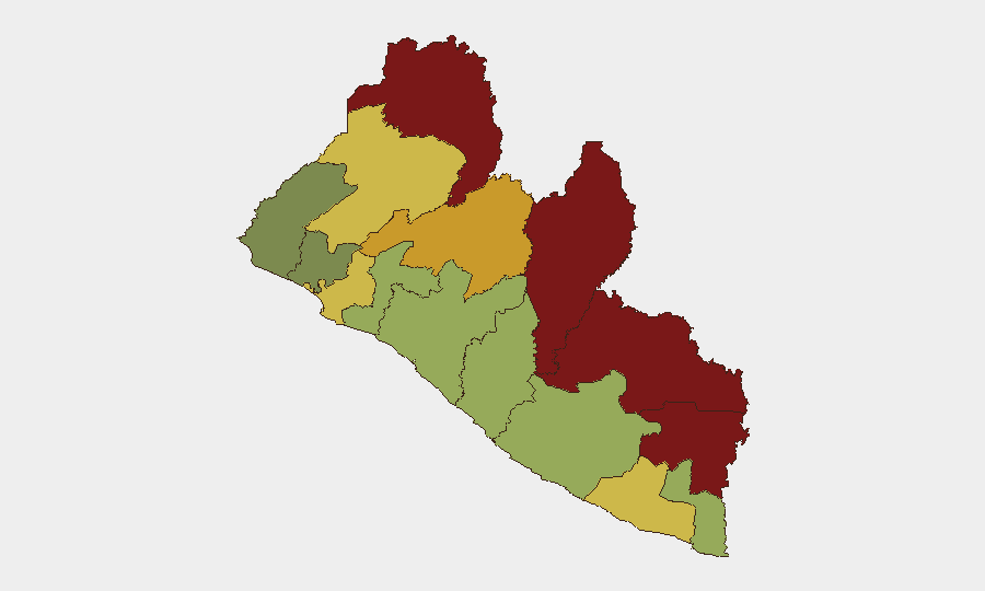
Nimba County (risk score 92) and Lofa County (88) drive national vulnerability, followed by Grand Gedeh (85) and River Gee (83). These four northeastern and eastern border counties account for the highest concentrations of tracked risk factors: cross-border armed-group presence, limited state security capacity, porous frontier control, and historic communal and resource-driven conflict. Montserrado County (64), home to the capital Monrovia, ranks eighth but carries elevated risk due to dense urbanization, economic disparities, and sporadic crime. The southern counties (Sinoe, Grand Bassa, Grand Kru) show lower but non-negligible scores, reflecting secondary governance and crime concerns.
How GeoBit Would Assist
Intel Sweep and OSINT fusion & corroboration capabilities enable continuous monitoring of Liberian conflict, crime, and political signals across open-source feeds, social media, and regional networks—critical for early detection of protests, armed activity, or instability in high-risk counties. AOI monitoring & early warning with persistent geographic watches on Nimba, Lofa, and Grand Gedeh would provide real-time alerting if events emerge, allowing duty-of-care teams to trigger contingency protocols before incidents escalate. Routing & network analysis supports alternative route planning and safe-passage assessment for personnel and assets moving between Monrovia and the interior, while conflict & military force-structure tracking documents armed-group disposition in border zones.
7-Day Outlook
No acute trigger events are forecast for the next 7 days based on current open-source signals. Liberia's baseline security posture—characterized by chronic unemployment, weak rule of law, and residual tensions in border regions—will likely persist unchanged. Any spike would most likely originate in the north (Nimba/Lofa) tied to cross-border militia activity or resource conflict, rather than capital-area instability.
Highest-Risk Areas — Ranked
| # | State / Region | Risk |
|---|---|---|
| 1 | Nimba County | 92 |
| 2 | Lofa County | 88 |
| 3 | Grand Gedeh County | 85 |
| 4 | River Gee County | 83 |
| 5 | Bong County | 72 |
| 6 | Gbarpolu County | 68 |
| 7 | Grand Kru County | 65 |
| 8 | Montserrado County | 64 |
| 9 | Rivercess County | 58 |
| 10 | Sinoe County | 55 |
| 11 | Margibi County | 52 |
| 12 | Grand Bassa County | 48 |
Sources
- geobit.ai
- smartnewsliberia.com
- euronews.com
- facebook.com
- fpa.news
- thenewdawnliberia.com
- micat.gov.lr
- knewsonline.com
- liberianinvestigator.com
- smartnewsliberia.com
- liberianinvestigator.com
- liberianinvestigator.com
- thenewdawnliberia.com
- thenewsnewspaperonline.com
- lina.micat.gov.lr
- openwatch.io
- knewsonline.com
- thenewdawnliberia.com
Previous Daily Briefs
A new Liberia brief is written every day — each with its own risk map and downloadable CSV. Here's the last week; use the calendar to go further back.
📅 Browse every day by calendar →
Highlighted days have a brief. Tap a day for that day's map & analysis, or “csv” for that day's dataset ($5).
Atlas — our AI intelligence desk — emails them this snapshot personally. Nothing else, no list.