Situation Summary
Luxembourg remains a low-threat jurisdiction with a composite score of 2 and no tracked discrete security events. The security environment is stable with no credible reports of civil unrest, terrorism, or infrastructure disruption. Recent activity consists of localized street crime, routine traffic violations, and petty theft—typical for a capital city and urban centre. The overall risk trajectory is flat.
Key Developments
- Luxembourg City, Rue Adolphe Fischer (Friday, 2026-07-24): Police investigated an assault following a motorist confrontation; two occupants of a second vehicle struck the victim, causing a lip injury. The incident was non-fatal and remains under investigation.
- Howald, Route de Thionville (Friday, 2026-07-24): Police responded to a report of an intoxicated man behaving erratically on public transport; he was removed, taken to a clinic, arrested following continued disruptive behaviour.
- Nationwide alcohol enforcement (overnight Friday–Saturday, 2026-07-24 to 2026-07-25): Police conducted 341 breath tests at checkpoints in Luxembourg City, Weiswampach, Troisvierges, and Wincrange; 14 drivers tested positive, resulting in five immediate license withdrawals and eight traffic-code warnings.
- Rosport-Mompach recycling centre (Thursday, 2026-07-23): Thieves broke into construction containers and stole approximately 518 litres of diesel fuel from a tank; police opened an investigation.
- Luxembourg Airport (last 24–48 hours): A Ryanair flight diverted to Luxembourg due to a medical emergency; no wider operational disruption occurred.
- National fuel supply (last 24–48 hours): Authorities confirmed fuel supply remains secure despite extremely low Rhine water levels; immediate logistics risk is contained.
Highest-Risk Areas
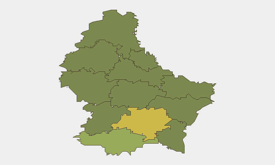
Luxembourg Canton (risk 68) and Esch Canton (risk 55) together account for the majority of sub-national risk, driven by urban density, traffic volume, and concentration of commercial and financial activity. Mersch Canton (risk 32) represents a secondary cluster. The gradient reflects typical urban/suburban/rural distribution patterns; outer cantons (Clervaux, Vianden, Wiltz) show minimal risk. Localized property crime and minor public-order incidents dominate the risk profile rather than organized violence or systemic threat.
How GeoBit Would Assist
Intel Sweep and OSINT fusion capabilities enable continuous monitoring of open-source local media, police reports, and social channels to detect emerging trends—e.g., crime pattern clustering or transport-network disruptions. AOI Monitoring & Early Warning on high-risk zones (Luxembourg and Esch cantons) with real-time alerting would flag any acceleration in assault, theft, or public-order incidents. Routing & Network Analysis supports duty-of-care teams in identifying safe transit corridors and alternative logistics routes during transport-linked incidents or fuel-supply volatility.
7-Day Outlook
No material escalation is anticipated. Routine traffic enforcement and localized street crime will likely continue; weekend activity levels typically generate minor public-order incidents consistent with the last 24–48 hours. Monitoring of fuel supply and Rhine logistics corridors should persist given seasonal water-level sensitivity, though current risk remains low. Corporate personnel and asset movements face negligible security constraint.
Highest-Risk Areas — Ranked
| # | State / Region | Risk |
|---|---|---|
| 1 | Luxembourg Canton | 68 |
| 2 | Esch Canton | 55 |
| 3 | Mersch Canton | 32 |
| 4 | Capellen Canton | 28 |
| 5 | Grevenmacher Canton | 22 |
| 6 | Diekirch Canton | 18 |
| 7 | Echternach Canton | 16 |
| 8 | Redange Canton | 15 |
| 9 | Remich Canton | 14 |
| 10 | Wiltz Canton | 12 |
| 11 | Clervaux Canton | 10 |
| 12 | Vianden Canton | 8 |
Previous Daily Briefs
A new Luxembourg brief is written every day — each with its own risk map and downloadable CSV. Here's the last week; use the calendar to go further back.
📅 Browse every day by calendar →
Highlighted days have a brief. Tap a day for that day's map & analysis, or “csv” for that day's dataset ($5).
Atlas — our AI intelligence desk — emails them this snapshot personally. Nothing else, no list.