Situation Summary
Malta remains a low-threat environment globally (rank #165, composite score 5) with no confirmed security incidents in the past 24–48 hours meeting open-source verification thresholds. The island's threat profile is characterized by localized urban crime and migration-route exposure rather than organized violence or political instability. Three recent event signals (prison, journalist activity, and public statements by Malta, China, and the UK) are registered in the system but lack corroborating incident detail in live web research, warranting close monitoring rather than immediate escalation. The current security trajectory is stable, though maritime and regulatory friction points warrant routine attention.
Key Developments
- No confirmed discrete security incidents have been validated across open sources for Malta in the 24–48 hours ending 2026-07-02. Event signals logged by the platform (prison, journalist) require internal corroboration or source verification before operational briefing.
- Broader maritime-migration risk persists in waters adjacent to Malta as part of ongoing Central Mediterranean transit flows; however, no specific incident with confirmed date and location was isolated from social or news sources in the last 48 hours. This represents *standing risk*, not a new development.
- US–Iran maritime tension continues to affect Malta-flagged and Malta-related shipping; however, this reflects weeks-long regional friction rather than a discrete 24–48-hour escalation in Maltese territorial or port operations.
- Regulatory watch remains active: Food Safety and Security Authority advisories and port-state control actions are routine administrative functions; none flagged as incident-level in the past two days.
- Public statements from Malta, UK, and China (2026-07-01 to -02) are logged but lack open-source detail sufficient to assess operational impact on corporate operations or travel.
Highest-Risk Areas
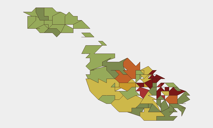
Valletta, Sliema, and Saint Julian's drive the composite risk ranking (scores 95, 92, 90 respectively), reflecting high population density, transient populations, and concentration of tourism, hospitality, and financial services. These harbor districts and urban centers account for most reported street-level crime, petty theft, and administrative friction. Mid-tier risk zones (Hamrun, Paola, Msida, Birkirkara) show similar patterns associated with residential density and traffic corridors. The Three Cities (Birgu, Senglea, Cospicua) and southern industrial zones (Żabbar) carry slightly lower but persistent risk scores, driven by port activity, maritime labor dynamics, and limited emergency-response capacity in some quarters. Risk is *localized and manageable*; no area meets "avoid" threshold for corporate operations.
How GeoBit Would Assist
AOI Monitoring & Early Warning would establish persistent watch on Valletta port and financial-district corridors, plus maritime zones near Maltese territorial waters, triggering alerts on unusual activity or gathering intelligence gaps. Intel Sweep and multi-source OSINT fusion would consolidate fragmented event signals (prison, journalist activity, public statements) and cross-reference with Telegram/X feeds, radio SIGINT, and regional conflict data to confirm or rule out operational risk before it surfaces in public reporting. Maritime & Aviation Tracking combined with Routing & Network Analysis would allow security teams to plan alternative port approaches and supply-chain resilience during migration surges or regional maritime friction.
7-Day Outlook
No material escalation is forecast for the next seven days absent new regional conflict spillover (Levantine instability, UK–EU friction on migration policy) or internal political triggering event. Routine port operations, summer tourism flow, and migration-route management will likely continue as baseline risk. Weekly monitoring for event-signal corroboration and maritime-incident updates recommended.
Highest-Risk Areas — Ranked
| # | State / Region | Risk |
|---|---|---|
| 1 | Valletta | 95 |
| 2 | Sliema | 92 |
| 3 | Saint Julian's | 90 |
| 4 | Gżira | 88 |
| 5 | Hamrun | 87 |
| 6 | Paola | 86 |
| 7 | Msida | 85 |
| 8 | Birkirkara | 84 |
| 9 | Birgu | 83 |
| 10 | Senglea | 82 |
| 11 | Cospicua | 81 |
| 12 | Żabbar | 80 |
Sources
Previous Daily Briefs
A new Malta brief is written every day — each with its own risk map and downloadable CSV. Here's the last week; use the calendar to go further back.
📅 Browse every day by calendar →
Highlighted days have a brief. Tap a day for that day's map & analysis, or “csv” for that day's dataset ($5).