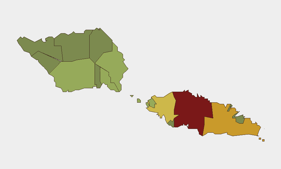
Situation Summary
Samoa presents a low-threat, stable operating environment as of 2 August 2026, with no verified security incidents, civil unrest, significant crime spikes, or infrastructure disruptions reported in the last 24–48 hours. Open-source monitoring across Samoan news outlets, government channels, and regional travel-advice feeds confirms routine activity only, with Australian government travel advisories continuing to recommend "exercise normal safety precautions" with no new alerts. The composite national threat score of 21 reflects a historically quiet security posture, though regional variance—driven primarily by Tuamasaga district—warrants differentiated risk management by asset location.
Key Developments
- No discrete security, civil-unrest, crime, or infrastructure incidents reported in Samoa in the last 24–48 hours. Multi-source web monitoring, Samoan news outlets (Samoa Global News, Newsline Samoa, PMN Samoa), and government social channels show no emergency alerts, protests, violence, or travel disruptions. *(Samoa, national; 2–3 August 2026)*
- Government of Samoa official channels focused on routine governance and health cooperation. Recent public communications highlight student achievements, ceremonial events, and inter-agency coordination, with no emergency or security notices flagged. *(Apia; 2–3 August 2026)*
- Australian Smartraveller advisory remains unchanged—no new warnings or curfew notices for Samoa. The standing recommendation to "exercise normal safety precautions" has not been revised, indicating no acute risk developments recognized by regional authorities. *(National; as of 2 August 2026)*
- Nearest regional aviation incident (American Samoa) now resolved and outside monitoring scope. A Samoa Airways aircraft runway excursion at Fitiuta Airport (American Samoa) occurred 28–29 July 2026; the airport has since reopened and the incident caused only minor injury. *(Fitiuta, American Samoa; 28–29 July 2026—not independent Samoa)*
Highest-Risk Areas
Tuamasaga (risk score 85) and Ātua (71) together account for the majority of sub-national risk concentration. Tuamasaga, which includes the capital Apia and the primary commercial and port infrastructure, drives elevated scores likely due to density of population, assets, and economic activity—standard for capital regions—rather than acute security threats. Ātua follows at a significant distance (71), suggesting secondary exposure. The remaining districts fall progressively to lower risk bands, with Vaisigano and Vaʻa-o-Fonoti presenting minimal concern (28, 23 respectively). Teams with assets or personnel in Tuamasaga should maintain standard protective measures; those in outlying regions face negligible risk.
How GeoBit Would Assist
Security teams operating in Samoa should employ AOI Monitoring & Early Warning on Tuamasaga district (Apia, port, commercial zones) to detect emerging civil unrest, labour disruptions, or political instability before they escalate. OSINT Fusion & Corroboration (X/Twitter, news feeds, government channels, sentiment analysis) provides cost-effective continuous watch of the operating environment and allows rapid distinction between rumour and verified threat. For duty-of-care teams managing travel or supply-chain routing, Routing & Network Analysis can model alternative movement corridors away from Apia in the event of sudden port or capital-area disruption, while Maritime & Aviation Tracking monitors key transport nodes for operational impact.
7-Day Outlook
No near-term drivers of instability are visible in current reporting or calendar events. Samoa's trajectory remains stable, with low likelihood of acute security escalation in the coming week. Routine monitoring for political developments, weather (cyclone season considerations), and port/labour news is prudent but indicates no heightened alert posture is warranted at this time.
Highest-Risk Areas — Ranked
| # | State / Region | Risk |
|---|---|---|
| 1 | Tuamasaga | 85 |
| 2 | Ātua | 71 |
| 3 | Aʻana | 62 |
| 4 | Aiga-i-le-Tai | 55 |
| 5 | Faʻasaleleaga | 48 |
| 6 | Palauli | 42 |
| 7 | Satupaʻitea | 38 |
| 8 | Gagaʻemauga | 35 |
| 9 | Gagaʻifomauga | 32 |
| 10 | Vaisigano | 28 |
| 11 | Vaʻa-o-Fonoti | 23 |
Sources
Previous Daily Briefs
A new Samoa brief is written every day — each with its own risk map and downloadable CSV. Here's the last week; use the calendar to go further back.
📅 Browse every day by calendar →
Highlighted days have a brief. Tap a day for that day's map & analysis, or “csv” for that day's dataset ($5).
Atlas — our AI intelligence desk — emails them this snapshot personally. Nothing else, no list.