Situation Summary
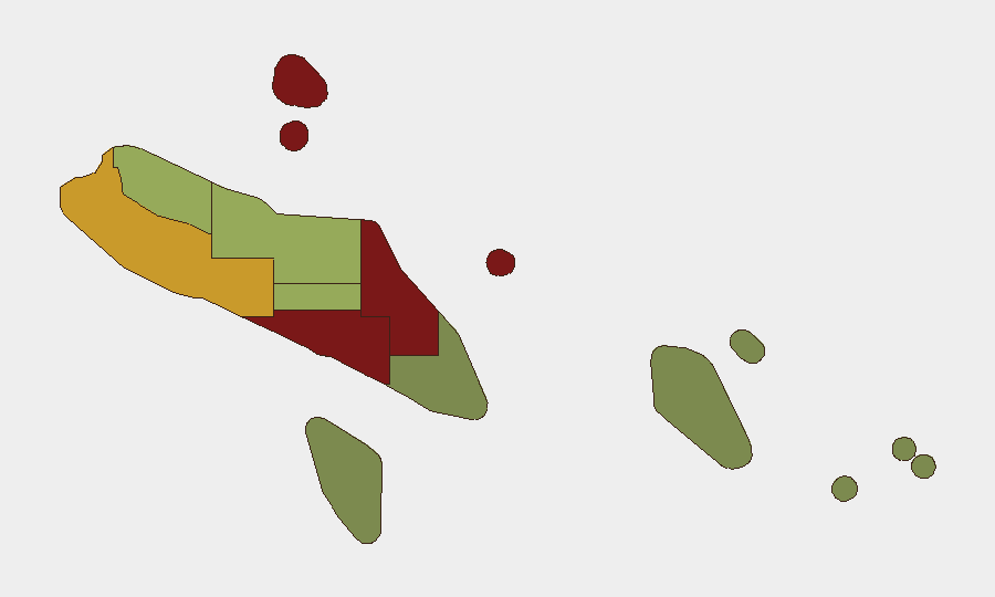
Solomon Islands remains stable with no acute security incidents reported in the past 24–48 hours. However, underlying vulnerabilities persist: Honiara and Guadalcanal province continue to carry elevated risk scores (92 and 88 respectively), driven by historical patterns of gang activity, property crime, and community tensions rather than current escalation. The security environment is characterized by chronic rather than acute threat drivers, with no indication of deterioration or improvement over the immediate outlook.
Key Developments
No discrete acute security events were recorded in Solomon Islands during 1–2 August 2026. Current-status assessments confirm absence of reported civil unrest, armed clashes, major criminal incidents, infrastructure disruption, or transport/port disruption in the past 24–48 hours.
*Note: Recent background context (outside the current window):*
- Gold Ridge mine landslide, Central Guadalcanal, 27–28 July — Environmental hazard affecting mining infrastructure; no reported casualties or regional security spillover.
- U.S.–Solomon Islands Shiprider agreement signing, Honiara, 29 July — Maritime law-enforcement cooperation framework; reflects ongoing regional security engagement but not a threat indicator.
Highest-Risk Areas
Honiara (risk 92) and Guadalcanal province (risk 88) dominate the threat profile and reflect well-documented patterns of gang-affiliated street crime, property theft, and episodic community violence, particularly in the capital's informal settlements and fringe areas. Malaita province (risk 85) carries elevated scores tied to historical intercommunal tensions and weapon availability. Western province (risk 72) reflects lower but measurable exposure to petty crime and limited state presence. Mid- and lower-risk provinces (Choiseul, Isabel, Central, Makira-Ulawa, Rennell–Bellona, Temotu) show declining composite risk, with remote and sparsely populated regions posting minimal current threat signals. Corporate and NGO staff concentration in Honiara and Guadalcanal places asset and personnel exposure squarely in the country's two highest-risk jurisdictions.
How GeoBit Would Assist
Teams with personnel or assets in Solomon Islands should employ AOI Monitoring & Early Warning to track Honiara and Guadalcanal for escalation signals, coupled with OSINT Sweep and multi-language social-media intelligence to detect emerging civil tensions or crime clusters before they impact operations. Routing & Network Analysis can identify safer transport corridors and alternative supply chains to mitigate exposure to high-crime zones, while Intel Sweep with conflict and crime-specific search provides ongoing baseline validation of the security posture and alerts to any shift in threat trajectory.
7-Day Outlook
No acute catalysts are evident for deterioration over the next 7 days. Honiara and Guadalcanal are expected to maintain their current risk profile—elevated but stable—barring sudden political upheaval, labor action, or weather-driven infrastructure failure. Duty-of-care teams should maintain standard security protocols for high-risk urban environments and continue passive monitoring for any change in the baseline.
Highest-Risk Areas — Ranked
| # | State / Region | Risk |
|---|---|---|
| 1 | Honiara | 92 |
| 2 | Guadalcanal | 88 |
| 3 | Malaita | 85 |
| 4 | Western | 72 |
| 5 | Choiseul | 58 |
| 6 | Isabel | 52 |
| 7 | Central Province | 48 |
| 8 | Makira-Ulawa | 38 |
| 9 | Rennell and Bellona | 22 |
| 10 | Temotu | 18 |
Sources
Previous Daily Briefs
A new Solomon Islands brief is written every day — each with its own risk map and downloadable CSV. Here's the last week; use the calendar to go further back.
📅 Browse every day by calendar →
Highlighted days have a brief. Tap a day for that day's map & analysis, or “csv” for that day's dataset ($5).
Atlas — our AI intelligence desk — emails them this snapshot personally. Nothing else, no list.