Situation Summary
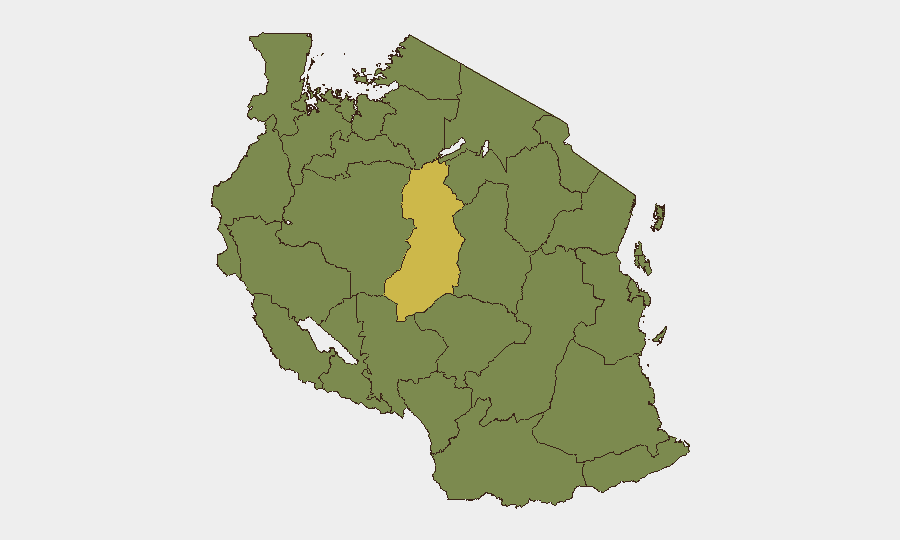
Tanzania remains at Tier 2 global risk (rank #46, composite score 48) with no confirmed civil unrest, acute crime, infrastructure failure, or travel impediment detected in the last 24–48 hours. Wildfire activity across multiple regions on 2026-06-24 is the primary current operational signal, though impact assessments remain under review. The security environment is stable in major urban and business centers, but sub-national risk is heavily concentrated in the northwestern and central lake regions.
Key Developments
- Multiple regions, Tanzania — 2026-06-24: Wildfire activity confirmed across several parts of Tanzania; specific geographic extent and asset impact remain under assessment by GeoBit field review.
- Tanzania (countrywide) — 2026-06-23 to 2026-06-24: No confirmed incidents of civil unrest, acute criminal activity, infrastructure failure, or travel impediment reported in the last 48 hours.
- Rwanda — 2026-06-24: Arrest/detention event reported; cross-border implications for Tanzania security posture unclear pending corroboration.
- Delegate-level statement — 2026-06-24: Public statement issued; context and target audience under analysis.
Highest-Risk Areas
Singida Region dominates the risk landscape (score 63.7), significantly outpacing all other zones and meriting targeted monitoring. The northwestern lake belt—Kigoma, Kagera, Mwanza, Geita, Shinyanga, and Tabora regions—clusters at elevated but uniform risk (33.7 each), suggesting either persistent low-intensity activity or data-collection patterns that warrant clarification. Katavi, Rukwa, Songwe, Mara, and Simiyu regions round out the high-risk geography. The concentration of risk in remote, resource-rich, or border-proximate regions aligns with historical patterns of artisanal mining activity, cross-border movement, and limited state presence; Singida's elevation suggests either recent event clustering or distinctive operational conditions not yet isolated in open reporting.
How GeoBit Would Assist
Corporate security teams with personnel or assets in high-risk regions should employ Area-of-Interest (AOI) Monitoring & Early Warning on Singida and the lake-belt regions to detect emerging civil unrest, crime spikes, or infrastructure disruption before operational impact. GIS & Spatial Analysis combined with Satellite & Imagery analysis can assess wildfire extent, smoke-impact corridors, and access routes in real time. Intel Sweep and multi-language OSINT fusion (X/Twitter, Telegram, local radio SIGINT) provide continuous detection of unconfirmed incidents, border activity, and delegate-level policy shifts that may affect business continuity or duty-of-care obligations.
7-Day Outlook
Wildfire activity is expected to remain the dominant operational signal through early July, dependent on seasonal weather patterns and regional humidity. No imminent escalation in civil unrest or border instability is forecast, though the Rwanda arrest/detention event and northwestern regional risk concentrations warrant continued passive monitoring. Corporate teams should assume stable operations in Dar es Salaam, Arusha, and Mbeya, but maintain contingency protocols for personnel in Singida and lake-region sites pending wildfire impact clarification.
Highest-Risk Areas — Ranked
| # | State / Region | Risk |
|---|---|---|
| 1 | Singida Region | 63.7 |
| 2 | Kigoma Region | 33.7 |
| 3 | Kagera | 33.7 |
| 4 | Mwanza Region | 33.7 |
| 5 | Geita | 33.7 |
| 6 | Shinyanga Region | 33.7 |
| 7 | Tabora Region | 33.7 |
| 8 | Katavi Region | 33.7 |
| 9 | Rukwa Region | 33.7 |
| 10 | Songwe Region | 33.7 |
| 11 | Mara Region | 33.7 |
| 12 | Simiyu | 33.7 |
Sources
Previous Daily Briefs
A new Tanzania brief is written every day — each with its own risk map and downloadable CSV. Here's the last week; use the calendar to go further back.
📅 Browse every day by calendar →
Highlighted days have a brief. Tap a day for that day's map & analysis, or “csv” for that day's dataset ($5).