Situation Summary
Togo presents a composite threat profile dominated by northern regional instability rather than capital-area or nationwide unrest. No discrete security incidents have been corroborated in open sources within the last 24–48 hours; however, structural vulnerabilities in the Savanes and Kara regions—driven by cross-border trafficking, militant activity, and porous frontier controls—remain the primary risk vector. The security posture in Grand Lomé reflects routine heightened surveillance rather than acute crisis, and the overall threat trajectory remains elevated but not acutely deteriorating.
Key Developments
- Information gap: No time-stamped, corroborated security, civil-unrest, conflict, or crime incidents have been identified in Togo within the last 24–48 hours via open-source and social-media channels. Older reporting (late July and prior) exists but falls outside the current analytical window.
- Sustained border surveillance in Grand Lomé (ongoing posture, not new incident): Local media references continued "frontières sous haute surveillance," indicating reinforced police and security presence around metropolitan perimeter checkpoints, consistent with standing operational posture rather than a response to a specific recent incident.
- Cross-border explosives trafficking signal (northern Benin, recent but non-Togo incident): Customs at Anoum checkpoint in northern Benin recently interdicted a truck carrying 3,295 sticks of explosives allegedly sourced from Kétao, Togo, and bound for Malanville. While the seizure occurred on Beninese soil and lacks precise dating within the 48-hour window, it underscores active trafficking networks linking northern Togo to regional supply chains—a persistent vulnerability indicator rather than a new escalation.
Highest-Risk Areas
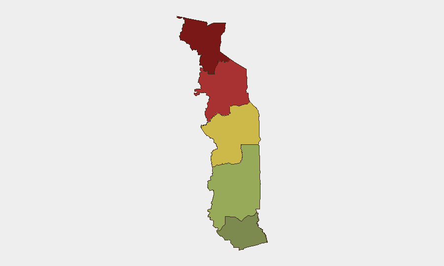
The Savanes Region (risk score 92) and Kara Region (risk score 78) drive the country's threat profile, reflecting entrenched cross-border militant presence, weapons and explosives trafficking via Benin and Burkina Faso, and limited state capacity in remote northern zones. The Centrale Region (65) carries secondary concern, while Maritime and Plateaux regions present substantially lower risk. Northern Togo's permeability to regional armed groups, combined with documented trafficking routes and weak frontier enforcement, creates the operational environment; capital-area risks remain manageable and administrative rather than acute.
How GeoBit Would Assist
Security teams with personnel or assets in Togo should deploy AOI Monitoring & Early Warning on Savanes, Kara, and Centrale regions to detect emerging conflict signals, roadblock activity, or militant movement in real time. OSINT fusion (multi-language web, X/Telegram, and local media sweep) would surface trafficking indicators and cross-border incidents (e.g., explosives, weapons, personnel flows) missed by English-language sources alone. Network & Actor Analysis combined with Border & Disputed-Territory search capabilities would map trafficking corridors, checkpoint vulnerabilities, and known militant nodes to inform routing decisions and liaison protocols with local authorities.
7-Day Outlook
Near-term trajectory remains stable with no indicators of imminent nationwide escalation or capital-area security breakdown. Northern regional volatility (Savanes/Kara) is expected to persist at current baseline, with sporadic trafficking interdictions and militia activity likely continuing. Organizations should maintain heightened vigilance in northern zones and monitor for any cascade effects from regional developments in Burkina Faso or Benin that could shift Togo's threat posture.
Highest-Risk Areas — Ranked
| # | State / Region | Risk |
|---|---|---|
| 1 | Savanes Region | 92 |
| 2 | Kara Region | 78 |
| 3 | Centrale Region | 65 |
| 4 | Plateaux Region | 45 |
| 5 | Maritime Region | 28 |
Sources
Previous Daily Briefs
A new Togo brief is written every day — each with its own risk map and downloadable CSV. Here's the last week; use the calendar to go further back.
📅 Browse every day by calendar →
Highlighted days have a brief. Tap a day for that day's map & analysis, or “csv” for that day's dataset ($5).
Atlas — our AI intelligence desk — emails them this snapshot personally. Nothing else, no list.