Situation Summary
Ukraine remains the second-highest-threat country globally, with 824 tracked security events and active warfare across multiple fronts as of 18 June 2026. Russian forces are conducting sustained, high-volume attacks on civilian and military targets nationwide, with particular intensity in eastern and northern oblasts. The pattern shows no de-escalation: 207 combat engagements were recorded on 17 June alone, concentrated in Pokrovsk, Huliaipole, and Kostiantynivka sectors, alongside coordinated drone and artillery strikes on infrastructure and populated areas. Duty-of-care risk remains acute and elevated across the country.
Key Developments
- Donetsk oblast, 17 June 2026: Russian forces conducted 1,065 strikes in a single 24-hour period, resulting in 4 civilian deaths, 17 wounded, and damage to 166 civilian facilities. This represents the highest single-day strike volume in current reporting.
- Kharkiv city and oblast, 17 June 2026: Russian attacks hit Kharkiv city and at least 12 settlements across the oblast, injuring at least 11 people including a teenager. Sustained pressure continues in this sector.
- Sumy oblast, 16–17 June 2026: Russian forces attacked six communities overnight (16–17 June), with follow-on strikes on Trostianets (4 injured) and Sumy city (major civilian infrastructure fire). Three additional injuries reported from overnight attacks.
- Dnipropetrovsk oblast, 17 June 2026: Over 40 drone attacks across five districts wounded 3 people and damaged civilian infrastructure; separate drone strike in Nikopol damaged a Ukrposhta mobile postal vehicle, injuring the driver.
- Kherson oblast, 17 June 2026: Russian shelling wounded 3 people, including a police officer, indicating continued offensive pressure in the south.
- Chernihiv oblast, 17 June 2026: Russian strikes hit two energy facilities, degrading regional power infrastructure.
- Frontline combat, 17 June 2026: Ukrainian authorities documented 207 engagements on the active front, with 47 concentrated in Pokrovsk and Huliaipole sectors, signaling sustained high-intensity warfare and elevated movement/travel risk in these zones.
Highest-Risk Areas
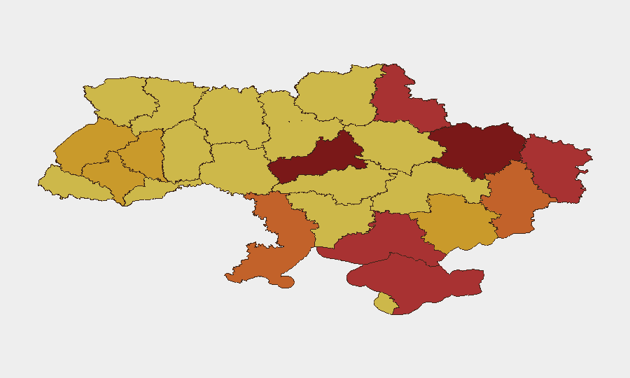
Kyiv and Cherkasy Oblast lead the sub-national ranking (100 and 98 respectively), reflecting both capital-city concentration and proximity to active military operations. Kharkiv, Sumy, and Luhansk oblasts form a high-risk arc in the north and northeast, where Russian forces are conducting the most intensive strike campaigns (1,065 strikes in Donetsk in 24 hours; sustained attacks on six Sumy communities). Donetsk and Zaporizhia oblasts remain contested, with frontline activity concentrated near Pokrovsk and Kostiantynivka driving elevated risk. Energy infrastructure damage across Chernihiv and multiple eastern oblasts is compounding humanitarian and operational vulnerabilities.
How GeoBit Would Assist
Security teams should employ AOI Monitoring & Early Warning with persistent geofencing around key facilities and movement corridors in Kyiv, Kharkiv, Sumy, and Donetsk; Battle Mapping & Conflict tracking to monitor real-time frontline positions and engagement density near Pokrovsk and Kostiantynivka; and OSINT fusion (social media, Telegram, local reporting) to detect emerging attack patterns and infrastructure damage. Routing & Network Analysis supports alternative journey planning to avoid active engagement zones. Satellite and imagery analysis can track damage to critical civilian and energy infrastructure, informing facility resilience assessments.
7-Day Outlook
Russian strike tempo is expected to remain elevated across eastern and northern oblasts through the coming week, with continued targeting of energy infrastructure and civilian areas. Frontline combat intensity near Pokrovsk and Kostiantynivka will likely persist, sustaining high movement and supply-line risk. Personnel and asset security measures should remain at maximum vigilance in all high-risk oblasts, particularly Kyiv, Kharkiv, Donetsk, and Sumy.
Highest-Risk Areas — Ranked
| # | State / Region | Risk |
|---|---|---|
| 1 | Kyiv | 100 |
| 2 | Cherkasy Oblast | 98 |
| 3 | Kharkiv Oblast | 84.2 |
| 4 | Sumy Oblast | 79.6 |
| 5 | Autonomous Republic of Crimea | 78.2 |
| 6 | Luhansk Oblast | 76.4 |
| 7 | Kherson Oblast | 76.3 |
| 8 | Odesa Oblast | 74.3 |
| 9 | Donetsk Oblast | 73.4 |
| 10 | Ivano-Frankivsk Oblast | 72.5 |
| 11 | Zaporizhia Oblast | 71.7 |
| 12 | Ternopil Oblast | 71.2 |
Sources
Previous Daily Briefs
A new Ukraine brief is written every day — each with its own risk map and downloadable CSV. Here's the last week; use the calendar to go further back.
📅 Browse every day by calendar →
Highlighted days have a brief. Tap a day for that day's map & analysis, or “csv” for that day's dataset ($5).