Situation Summary
Burkina Faso remains at composite threat level 69 (global rank #21), driven primarily by ongoing insurgency activity concentrated in the North region. The country has experienced 18 tracked security events in the current monitoring cycle, with diplomatic friction involving U.S. expulsion/detention actions and localized armed clashes recorded in the past 48 hours. Risk distribution across the 12 regions shows significant concentration in the North (78.6), with a secondary tier of moderate elevated risk (48.6) across most other zones. The security environment reflects entrenched militant pressure, civilian displacement, and a strained governance-international relations backdrop.
Key Developments
- 2026-06-13 · Expulsion/Diplomatic Action: United States expelled or suspended personnel from Burkina Faso; reciprocal detention of U.S. nationals recorded by Burkinabé authorities. Specific locations and operational details remain limited in available reporting.
- 2026-06-13 · Arrest/Detention (Police): Law enforcement conducted arrests involving at least one U.S. national; precise location and charges not confirmed in current feeds.
- 2026-06-14 · Armed Engagement: Small arms combat involving BAHAMA (militant actor) recorded; geographic coordinates and casualty figures unavailable.
- 2026-06-14 · Property Seizure/Damage: Pirate or militant group conducted asset seizure/destruction; location and asset type not yet itemized.
- 2026-06-13 · Public Statement: BAHAMA released media statement via outlets; content and specific claims require direct source review.
*Note:* Verifiable incident-level detail for 13–14 June 2026 remains sparse in open-source corroboration. Regional news wires (AFP, Reuters, Radio Omega, Burkina24) and French-language Twitter accounts tracking security should be monitored for updates. ACLED and Crisis Group trackers may publish event confirmations with a 24–72 hour lag.
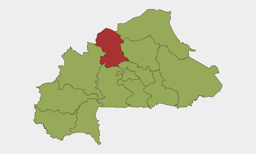
Highest-Risk Areas
The North region (78.6) is the critical threat driver, reflecting sustained militant operations, intercommunal conflict, and limited state control. The remaining 11 regions cluster at 48.6, indicating a broad secondary elevation across the country rather than isolated hotspots. This pattern suggests that while the North demands the most urgent mitigation, operations in the Central, Eastern, Western, and Sahelian zones face meaningful risk from dispersed insurgent cells, bandit networks, and property crime. Organizations with personnel or assets in Ouahigouya, Dori, Djibo, Fada, and Kaya (North) face the highest probability of direct threat contact; those in secondary cities (Kaya, Tenkodogo, Bobo-Dioulasso, Gaoua) should anticipate secondary-level exposure.
How GeoBit Would Assist
Security teams should employ AOI Monitoring & Early Warning to establish persistent watch over key facilities and travel corridors in the North and Central regions, with alerting on new event clusters. Intel Sweep and multi-language OSINT (French-language X, regional radio, local news outlets) provide real-time incident detection and corroboration, critical given the 24–72 hour lag in formal reports. Routing & Network Analysis enables secure alternative journey planning and personnel movement avoidance of high-threat corridors; Conflict & Military force-structure tracking clarifies militant group positioning and capability shifts.
7-Day Outlook
Near-term trajectory suggests sustained low-to-moderate insurgent activity in the North with periodic armed engagements, absent a major operational escalation or ceasefire announcement. Diplomatic friction with the United States may create secondary administrative or consular delays for international personnel. Organizations should anticipate continued property crime and intercommunal tension across secondary regions, with travel and supply-chain disruption remaining probable.
Highest-Risk Areas — Ranked
| # | State / Region | Risk |
|---|---|---|
| 1 | North | 78.6 |
| 2 | Upper-Basins | 48.6 |
| 3 | Boucle du Mouhoun | 48.6 |
| 4 | Central-West | 48.6 |
| 5 | Central-South | 48.6 |
| 6 | Central-East | 48.6 |
| 7 | Waterfalls | 48.6 |
| 8 | Southwest | 48.6 |
| 9 | Sahel | 48.6 |
| 10 | Central-North | 48.6 |
| 11 | East | 48.6 |
| 12 | Centre | 48.6 |
Sources
Previous Daily Briefs
A new Burkina Faso brief is written every day — each with its own risk map and downloadable CSV. Here's the last week; use the calendar to go further back.
📅 Browse every day by calendar →
Highlighted days have a brief. Tap a day for that day's map & analysis, or “csv” for that day's dataset ($5).