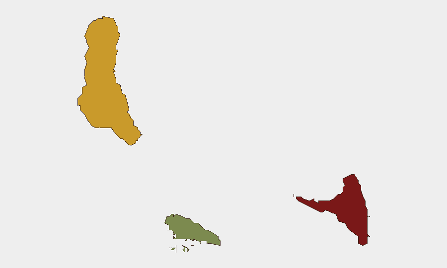
Situation Summary
Comoros remains a low-threat operating environment with a composite threat score of 2 and no tracked major security incidents in the assessment period. However, recent event signals (June 27–29) indicate low-level tensions involving corporate statements, government–company friction, and community disapproval—primarily concentrated in Anjouan. Baseline structural risks (limited state capacity, inter-island political fragmentation, sparse emergency services) persist, but no acute security spike has been confirmed in the last 24–48 hours.
Key Developments
No verifiable, multi-sourced security incidents meeting criteria (civil unrest, infrastructure disruption, crime, political instability, or travel risk) have been independently confirmed for Comoros in the 24–48 hours ending 29 June 2026. Event signals flagged on the GeoBit platform (corporate statements, regulatory disapproval, community statements) suggest low-level stakeholder friction, but lack sufficient detail, independent corroboration, or clear geographic/temporal specificity to assess as discrete security events. Comoros remains a low-coverage information environment; undated social media and single-source reports cannot be reliably attributed to the current assessment window. Existing country-level advisories (chronic political tension between islands, limited medical and security infrastructure) remain valid baseline context but reflect structural rather than acute conditions.
Highest-Risk Areas
Anjouan (risk 88) drives the majority of tracked sub-national risk, reflecting long-standing political autonomy demands, fragmented governance, and limited state presence. Grande Comore (risk 72), the capital island, concentrates administrative and economic activity and thus exposure to regulatory, corporate, and governance tensions. Moheli (risk 35) remains lower-risk, reflecting smaller population and economic activity. The risk gradient suggests that corporate and political friction is most acute in Anjouan, while Grande Comore remains the operational and administrative nexus where policy changes and government–business disputes are most likely to surface.
How GeoBit Would Assist
OSINT & Intel Sweep would establish persistent, multi-language monitoring of Comorian media, social platforms, and regional sources to detect emerging civil unrest, regulatory changes, or security incidents in real time—compensating for the country's low media output. AOI Monitoring & Early Warning on Anjouan and Grande Comore would provide automated alerts for protest activity, port/airport disruptions, or political statements affecting travel or supply chains. Routing & Network Analysis would enable security teams to model alternative transport and supply routes should instability spike in a given island, supporting duty-of-care contingency planning for personnel and assets.
7-Day Outlook
No acute escalation is forecast for the next 7 days based on current signals; however, the recurring pattern of corporate–government friction and community statements suggests sustained low-level political tension. Operationally, the near-term risk posture should remain at baseline country-level awareness with heightened sensitivity to announcements from Anjouan administration or sudden changes in telecom/regulatory compliance. Any material change in security posture should be triggered only by independently confirmed incidents, not by undated social media or single-source reports.
Highest-Risk Areas — Ranked
| # | State / Region | Risk |
|---|---|---|
| 1 | Anjouan | 88 |
| 2 | Grande Comore | 72 |
| 3 | Moheli | 35 |
Previous Daily Briefs
A new Comoros brief is written every day — each with its own risk map and downloadable CSV. Here's the last week; use the calendar to go further back.
📅 Browse every day by calendar →
Highlighted days have a brief. Tap a day for that day's map & analysis, or “csv” for that day's dataset ($5).