Situation Summary
East Timor presents a low-to-moderate overall threat environment (composite score 3, no major incidents in the last 24–48 hours). The country remains stable with no confirmed reports of civil unrest, significant crime spikes, political instability, or infrastructure disruption. Dili and western districts (Liquiçá, Baucau) carry elevated risk profiles relative to the national baseline, primarily reflecting historical gang activity, land disputes, and petty crime rather than acute security events. Regional cyber-security exercises and ASEAN-level messaging about emerging threats signal awareness of non-traditional risks, but pose no immediate, in-country threat.
Key Developments
- No verified security incidents reported in East Timor in the last 24–48 hours. Open web research, news outlets, and X/Twitter monitoring show no confirmed protests, violent crime, political instability, or infrastructure failures meeting incident-reporting thresholds.
- Regional cyber-security exercise ongoing (23–24 June 2026). ASEAN Expert Working Group on Cyber Security is conducting a table-top exercise ("Trident Resolve") in which Timor-Leste participates indirectly; reflects regional focus on cyber resilience but not a localized incident.
- ASEAN regional security messaging emphasizes "new challenges" and unity (23 June 2026, Bangkok). ASEAN partners highlighted shifting traditional security assumptions and non-traditional threats; frames Timor-Leste's broader strategic context but does not report specific in-country activity.
- Tracked signal: "East Timor vs Russian" (22 June 2026, status: Investigate). Preliminary flag in GeoBit's event-feed system; full context and verification status pending. No corroborating mainstream reporting available at this time.
- Dili and Liquiçá districts remain highest-risk urban/peri-urban zones. Persistent baseline concerns (gang presence, informal settlement disputes) unchanged; no acute escalation reported this cycle.
Highest-Risk Areas
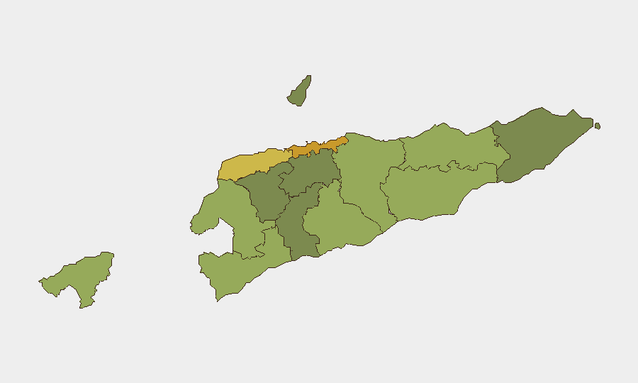
Dili (risk 72) and Liquiçá (risk 62) dominate the sub-national ranking, driven by concentration of gang-related activity, land-tenure conflicts, and petty crime in and around the capital. Baucau (58) and Cova Lima (55) follow, reflecting similar dynamics in secondary urban centers and border-adjacent areas. These districts' elevated scores are not driven by current, acute events, but by persistent structural vulnerabilities—informal settlements, youth unemployment, and weak formal dispute-resolution mechanisms—that create baseline susceptibility to violence. Western and central districts show lower risk, though Bobonaro (53, western border) warrants monitoring for cross-border smuggling and trafficking flows common in that region.
How GeoBit Would Assist
Security teams managing personnel or assets in Dili and Liquiçá would deploy AOI (Area-of-Interest) Monitoring & Early Warning on those high-risk districts, enabling persistent watch and real-time alerting if civil disturbances, crime spikes, or political activity spike. Multi-language OSINT and X/Twitter feeds would surface gang-related posturing, protest signaling, or labor unrest before mainstream reporting, extending lead time for duty-of-care response. Network & Actor Analysis can map gang structures and displacement patterns in Dili's informal settlements, informing avoidance routing and personal-security posture adjustments.
7-Day Outlook
No acute security escalation is forecast over the next seven days. Baseline risks remain concentrated in Dili and western districts; staff in those areas should maintain standard situational awareness. Regional cyber-security exercises will conclude by 24 June with no operational impact expected. Monitoring of the unresolved "East Timor vs Russian" signal will continue; further clarification may affect risk assessment if verified.
Highest-Risk Areas — Ranked
| # | State / Region | Risk |
|---|---|---|
| 1 | Dili | 72 |
| 2 | Liquiçá | 62 |
| 3 | Baucau | 58 |
| 4 | Cova Lima | 55 |
| 5 | Bobonaro | 53 |
| 6 | Oecussi-Ambeno | 48 |
| 7 | Manufahi | 45 |
| 8 | Viqueque | 42 |
| 9 | Manatuto | 40 |
| 10 | Ainaro | 38 |
| 11 | Ermera | 36 |
| 12 | Aileu | 32 |
Previous Daily Briefs
A new East Timor brief is written every day — each with its own risk map and downloadable CSV. Here's the last week; use the calendar to go further back.
📅 Browse every day by calendar →
Highlighted days have a brief. Tap a day for that day's map & analysis, or “csv” for that day's dataset ($5).