Situation Summary
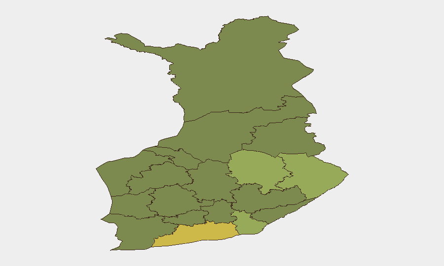
Finland remains a low-threat environment globally (rank #152, composite score 6), with no tracked security events at the national level as of 20 August 2026. Recent incidents—including an industrial fire, police conduct reviews, and localized criminal activity—are geographically dispersed and do not indicate systemic instability. The security picture is stable, though Uusimaa (Helsinki metro area) continues to register elevated composite risk (65) driven by urban crime density and police–community tensions rather than organized or political violence.
Key Developments
- Pedersöre, Ostrobothnia (20 Aug 2026): Police arrested three men on suspicion of attempted aggravated theft following an attempted break-in; one suspect also faced charges of aggravated drunk driving and driving without a licence. Police employed drone and canine assets in the rural search, demonstrating routine use of advanced techniques for minor property crime.
- Central Finland Police Conduct Referral (updated 20 Aug 2026): State Prosecutor Tapio Mäkinen confirmed that a case involving police conduct during a van-stop incident has been referred to the prosecutor general's office for review. The underlying event occurred earlier; the referral reflects ongoing internal accountability processes rather than a new incident.
- Helsinki Arson Investigation Closure (19 Aug 2026): Police announced eight suspects face arson charges in connection with a residential building fire in Lauttasaari that occurred earlier in the year. This represents completion of pre-trial investigation, not a fresh incident.
- Ongoing Airspace & Maritime Restrictions Monitoring (referenced 20 Aug 2026): Finland's temporary restrictions on eastern Gulf of Finland airspace and maritime traffic (imposed 14–18 Aug due to drone concerns) have been lifted. However, heightened awareness of potential drone activity near NATO borders and Russian proximity remains part of current security discourse.
- Police–Youth Relations Under Scrutiny (investigations active as of 18–20 Aug 2026): Criminal investigations remain open into both police conduct and a 15-year-old moped rider's actions following a pursuit in Tuusula on 8 August that resulted in injury. No new incidents reported in the past 48 hours, but ongoing case management reflects persistent tension between law enforcement and youth communities in Greater Helsinki.
Highest-Risk Areas
Uusimaa dominates the sub-national ranking (risk 65), reflecting Helsinki's urban density, property crime, and recent police–community friction over vehicle stops and use-of-force incidents. North Karelia, Kymenlaakso, and North Savo (risks 44, 42, and 40 respectively) show elevated scores likely linked to proximity to the Russian border, cross-border crime patterns, and economic stress in post-industrial regions. The concentration of risk in the eastern and central zones suggests that border-region smuggling, rural property crime, and police operational intensity are the primary drivers; no organized political violence or terrorism indicators are evident.
How GeoBit Would Assist
A security team protecting personnel or assets in Finland would deploy AOI Monitoring & Early Warning on Uusimaa and cross-border zones to detect emerging crime or unrest clusters; Intel Sweep and X/Twitter OSINT to track police conduct controversies and community sentiment in real time; and Routing & Network Analysis to identify safer travel corridors in higher-risk regions during personnel movement. Satellite & Imagery analysis combined with maritime and aviation tracking would provide early warning of renewed airspace restrictions or border anomalies.
7-Day Outlook
No significant escalation is anticipated. Routine police investigations and internal accountability processes will likely continue without disruption to public safety or business operations. Persistent monitoring of the eastern Gulf of Finland and border regions is warranted as a precaution against renewed drone activity or maritime incursions; however, the current trajectory remains stable.
Highest-Risk Areas — Ranked
| # | State / Region | Risk |
|---|---|---|
| 1 | Uusimaa | 65 |
| 2 | North Karelia | 44 |
| 3 | Kymenlaakso | 42 |
| 4 | North Savo | 40 |
| 5 | South Karelia | 38 |
| 6 | Kainuu | 36 |
| 7 | Päijät-Häme | 35 |
| 8 | South Savo | 32 |
| 9 | Kanta-Häme | 30 |
| 10 | Pirkanmaa | 28 |
| 11 | Central Finland | 26 |
| 12 | Southwest Finland | 25 |
Sources
Previous Daily Briefs
A new Finland brief is written every day — each with its own risk map and downloadable CSV. Here's the last week; use the calendar to go further back.
- August 18, 2026
- August 16, 2026
- August 14, 2026
- August 12, 2026
- August 10, 2026
- August 8, 2026
- August 6, 2026
📅 Browse every day by calendar →
Highlighted days have a brief. Tap a day for that day's map & analysis, or “csv” for that day's dataset ($5).
Atlas — our AI intelligence desk — emails them this snapshot personally. Nothing else, no list.