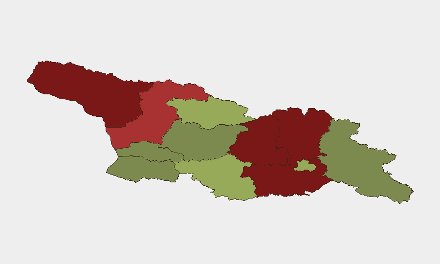
Situation Summary
Georgia (country) remains classified as a moderate-threat environment overall (composite score 12), with security risk heavily concentrated in the breakaway regions of Abkhazia and South Ossetia (mapped as Shida Kartli and Lower Kartli) and adjacent conflict-adjacent zones. The last 24–48 hours have produced no substantive new security incidents in the GeoBit monitoring feed; the most recent tracked signals relate to flood events in scattered locations. The security posture is stable but remains fragmented by long-standing territorial disputes and infrastructure vulnerabilities in high-risk zones.
Key Developments
No qualifying security or unrest incidents were reported in Georgia during the last 24–48 hours. The two most recent event signals in the GeoBit feed relate to flooding (Events 1103959 and 1103909), which suggest weather-related infrastructure risk rather than security deterioration. Duty-of-care teams with personnel or assets in flood-affected areas should verify local water management and transport corridor status; specific locations and dates for these events were not resolved in available search results and require direct field confirmation or local authority contact.
Highest-Risk Areas
Abkhazia (risk 95) and South Ossetia/Shida Kartli (risk 88) dominate the threat landscape—both are Russian-backed de facto states with limited international recognition, active military presences, and ongoing border tensions with Tbilisi-controlled territory. Lower Kartli (risk 85) and Mtskheta-Mtianeti (risk 82) follow as contested or buffer zones with periodic skirmishes, checkpoint activity, and restricted access for foreign nationals. By contrast, Tbilisi itself (risk 45) and the southwestern regions (Adjara, Imereti, Guria at 28–35) carry significantly lower risk, reflecting stronger state control and reduced separatist activity. Risk concentration in the north and east reflects proximity to Russian military installations and unresolved territorial status.
How GeoBit Would Assist
Organizations with staff or assets in Georgia should deploy AOI Monitoring & Early Warning on Abkhazia, South Ossetia, and buffer-zone checkpoints to detect military activity, border incidents, or movement restrictions in real time. Intel Sweep and multi-language OSINT (including Telegram, local news, and X/Twitter) provide 24–48-hour lead time on unrest, curfews, or route disruptions before they affect operations. GIS & Spatial Analysis combined with satellite imagery enable situational awareness of checkpoint positions, road closures, and flood-damaged infrastructure—critical for alternative-route planning and duty-of-care decisions around movement or evacuation.
7-Day Outlook
No imminent escalation is forecast. Baseline tensions in breakaway territories remain chronic rather than acute; flood-related infrastructure impacts in non-conflict zones will likely resolve within days pending drainage and road restoration. Security teams should maintain heightened awareness for weather-driven access restrictions and monitor checkpoint activity in border zones via persistent OSINT, but no spike in political unrest or military action is anticipated over the next week.
Highest-Risk Areas — Ranked
| # | State / Region | Risk |
|---|---|---|
| 1 | Autonomous Republic of Abkhazia | 95 |
| 2 | Shida Kartli | 88 |
| 3 | Lower Kartli | 85 |
| 4 | Mtskheta-Mtianeti | 82 |
| 5 | Samegrelo-Upper Svaneti | 78 |
| 6 | Samtskhe-Javakheti | 48 |
| 7 | Tbilisi | 45 |
| 8 | Racha-Lechkhumi and Kvemo Svaneti | 42 |
| 9 | Kakheti | 38 |
| 10 | Autonomous Republic of Adjara | 35 |
| 11 | Imereti | 32 |
| 12 | Guria | 28 |
Sources
Previous Daily Briefs
A new Georgia brief is written every day — each with its own risk map and downloadable CSV. Here's the last week; use the calendar to go further back.
📅 Browse every day by calendar →
Highlighted days have a brief. Tap a day for that day's map & analysis, or “csv” for that day's dataset ($5).