Situation Summary
Grenada remains a low-threat environment globally (rank #92; composite threat score 12) with no confirmed security incidents reported in the past 24–48 hours. Open-source monitoring across news, official advisories, and social media yields no corroborated events tied to crime, unrest, political instability, or acute infrastructure failures during this window. The security picture is stable, though standing U.S. State Department Level 2 guidance ("exercise increased caution due to crime") and German Foreign Office alerts on petty crime and piracy remain in effect as general risk advisories rather than responses to imminent threats.
Key Developments
No specific security, crime, civil-unrest, infrastructure, or travel-risk incidents were confirmed for Grenada in the last 24–48 hours based on corroborated open-source and social media cross-reference.
Event signal data from 12 July 2026 shows diplomatic friction (Grenada–U.S. rejection, arrests, judicial statements, and internal government disapproval), but these do not translate to on-the-ground security impacts or location-specific incidents requiring duty-of-care response at this time.
Highest-Risk Areas
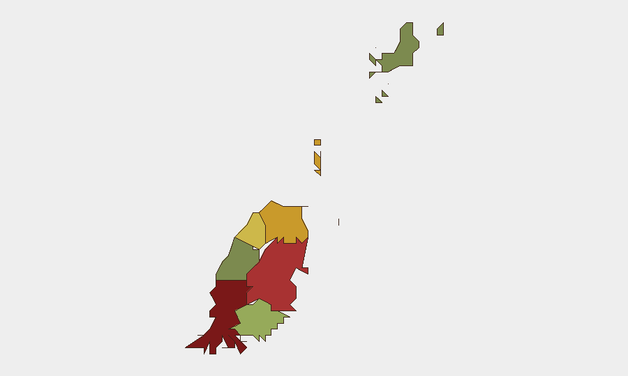
Saint George Parish (composite risk score 92) is the highest-risk sub-national area, driven primarily by petty crime concentration in the capital city and port zone; Saint Andrew (78) and Saint Patrick (71) follow, likely reflecting similar urban crime and gang activity. The southern and eastern parishes—Saint David (52), Saint John (38), and Carriacou & Petite Martinique (12)—carry substantially lower risk scores, suggesting crime and instability are urban-coastal phenomena. Corporate assets and personnel in St. George's should apply baseline heightened-caution protocols (situational awareness, secure transportation, secure facilities) but no acute threat escalation is indicated.
How GeoBit Would Assist
Security teams with staff or assets in Grenada should employ AOI Monitoring & Early Warning on Saint George Parish and the capital to detect emerging crime clusters, civil unrest, or port disruptions with real-time alerting. Intel Sweep and multi-language OSINT fusion (including X/Twitter, Telegram, and local news feeds) would provide continuous cross-reference to confirm absence of incidents or flag new signals within hours of occurrence. Routing & Network Analysis can identify secure, low-crime transit corridors in St. George's for personnel movement, and GIS & Spatial Analysis can overlay crime hotspots, checkpoints, and infrastructure vulnerabilities to inform site security and duty-of-care decisions.
7-Day Outlook
No escalation is forecast for the next 7 days. The diplomatic friction evident on 12 July (Grenada–U.S. tensions, arrests, judicial statements) shows no signs of triggering street-level unrest or security incidents. Baseline crime (petty theft, occasional gang activity) in Saint George will likely persist at historical levels; personnel and asset security should remain calibrated to standing Level 2 advisory guidance rather than heightened emergency posture.
Highest-Risk Areas — Ranked
| # | State / Region | Risk |
|---|---|---|
| 1 | Saint George | 92 |
| 2 | Saint Andrew | 78 |
| 3 | Saint Patrick | 71 |
| 4 | Saint Mark | 64 |
| 5 | Saint David | 52 |
| 6 | Saint John | 38 |
| 7 | Carriacou and Petite Martinique | 12 |
Sources
Previous Daily Briefs
A new Grenada brief is written every day — each with its own risk map and downloadable CSV. Here's the last week; use the calendar to go further back.
📅 Browse every day by calendar →
Highlighted days have a brief. Tap a day for that day's map & analysis, or “csv” for that day's dataset ($5).
Atlas — our AI intelligence desk — emails them this snapshot personally. Nothing else, no list.