Situation Summary
Guyana remains a low-frequency, composite-threat environment (global rank #null; composite score 18), with no discrete security incidents recorded in the current 24–48 hour window. The country's risk profile is regionally concentrated—driven primarily by crime and border-control challenges in the northern coastal regions (Demerara-Mahaica, Cuyuni-Mazaruni, Mahaica-Berbice)—rather than by political instability or organized conflict. The broader security picture reflects persistent endemic crime dynamics typical of the Caribbean basin, without evidence of imminent escalation or systemic breakdown.
Key Developments
No discrete security, civil-unrest, crime, infrastructure, or travel incidents meeting incident-level criteria (specific location, confirmed date within last 24–48 hours, multi-source corroboration) have been identified in the current window.
A diplomatic commentary piece (30 June 2026, national level) discusses Foreign Minister Carolyn Rodrigues-Birkett's UN candidacy and Guyana's recent positions on the Israel–Iran crisis, but this reflects policy debate rather than an operational security event.
An ongoing homicide investigation (Shavannie Hanoman case) continues to receive media attention; however, the underlying incident date cannot be precisely confirmed within the last 48 hours from available sources, and therefore is not included as a current development.
Recommended action: Security teams relying on this brief should note the absence of recent incident signals and rely on the sub-national risk ranking and baseline threat profile (below) for operational planning. Daily monitoring of coastal and interior border regions is appropriate given persistent crime-related risk scores.
Highest-Risk Areas
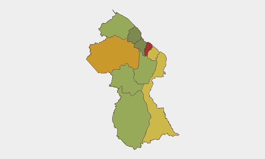
Demerara-Mahaica (risk 78) and Cuyuni-Mazaruni (risk 72) drive national risk, followed by Mahaica-Berbice (risk 65) and East Berbice-Corentyne (risk 62). These northern coastal and interior regions are primary sources of crime-related vulnerability, including organized property crime, trafficking, and cross-border smuggling activity. The interior regions (Cuyuni-Mazaruni, Upper Demerara-Berbice, Potaro-Siparuni) carry elevated scores reflecting border-control challenges, informal mining operations, and limited state presence. By contrast, southern and western regions (Essequibo Islands, Pomeroon-Supenaam, Upper Takutu-Upper Essequibo) show materially lower risk, indicating that corporate assets and personnel concentrated in Georgetown and coastal commercial zones face higher baseline exposure than remote or southern deployments.
How GeoBit Would Assist
AOI Monitoring & Early Warning would enable persistent watch of high-risk districts (Demerara-Mahaica, Cuyuni-Mazaruni) for crime-pattern shifts, protest activity, or infrastructure disruptions, with automated alerting. Intel Sweep, OSINT Fusion & Corroboration, and Network & Actor Analysis would track criminal-network movements, trafficking routes, and border-crossing activity in real time, allowing duty-of-care teams to adjust travel routes and site security posture. GIS & Spatial Analysis combined with Routing & Network Analysis supports alternative-route planning for personnel movement in high-risk zones and risk-informed site selection for new operations.
7-Day Outlook
No imminent destabilization or incident-cluster escalation is forecast for the next seven days. Crime rates and border-region tension are expected to remain consistent with baseline patterns. Security teams should maintain standard operational vigilance in coastal zones while monitoring for any shift in criminal-network activity or cross-border trafficking that might signal emerging pressure on state capacity.
Highest-Risk Areas — Ranked
| # | State / Region | Risk |
|---|---|---|
| 1 | Demerara-Mahaica | 78 |
| 2 | Cuyuni-Mazaruni | 72 |
| 3 | Mahaica-Berbice | 65 |
| 4 | East Berbice-Corentyne | 62 |
| 5 | Upper Demerara-Berbice | 58 |
| 6 | Potaro-Siparuni | 48 |
| 7 | Barima-Waini | 45 |
| 8 | Upper Takutu-Upper Essequibo | 42 |
| 9 | Pomeroon-Supenaam | 38 |
| 10 | Essequibo Islands | 35 |
Sources
Previous Daily Briefs
A new Guyana brief is written every day — each with its own risk map and downloadable CSV. Here's the last week; use the calendar to go further back.
📅 Browse every day by calendar →
Highlighted days have a brief. Tap a day for that day's map & analysis, or “csv” for that day's dataset ($5).