Situation Summary
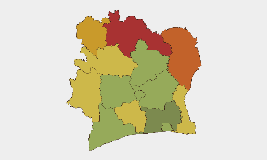
Ivory Coast remains a low-priority global security concern (rank #75, composite threat score 17) with no tracked security incidents in the current assessment window. The country's risk profile is geographically concentrated in its northern and northeastern border districts, driven by transnational crime, smuggling networks, and sporadic militant activity rather than active civil conflict. The southern coastal regions, including the capital Abidjan, maintain substantially lower threat levels. Overall trajectory remains stable with localized vulnerabilities rather than systemic destabilization.
Key Developments
No discrete security incidents were reliably reported in the last 24–48 hours. Available open-source reporting from the past week includes:
- Abidjan, 27 July — National PKI and digital trust infrastructure launch announced; cybersecurity governance strengthening but outside the immediate reporting window.
- Assinie (south-east), 8 July — Major narcotics seizure by national police; enforcement activity indicates continued drug-trafficking pressure in coastal zones, but incident predates the current 48-hour window.
- Ouellé, weekend 26–27 July — Fatal stabbing followed by vandalism and arson; police restored order. Localized criminal violence rather than organized threat, but outside the immediate window.
Assessment: No verified current-cycle incidents meeting threshold for inclusion. Live web research did not surface independently corroborated incidents from 2–3 August 2026. Single social-media claims (e.g., unverified Facebook posts about militant camps) lack newsroom confirmation and are not treated as reliable intelligence.
Highest-Risk Areas
The northern border belt—Savanes, Zanzan, Denguélé, and Comoé districts—accounts for the country's concentrated risk (scores 78, 75, 72, and 70 respectively). These regions are adjacent to Mali and Burkina Faso, where transnational organized crime, weapons smuggling, and cross-border militant networks operate with minimal state enforcement capacity. Montagnes District (risk 68) and Woroba (risk 65) extend this risk corridor westward along porous land borders. In contrast, Abidjan (risk 45) and the southern coastal belt remain substantially safer, with security challenges driven primarily by petty crime and port-zone trafficking rather than organized violence. Risk concentration is overwhelmingly a function of border proximity and weak territorial control rather than active insurgency or civil unrest.
How GeoBit Would Assist
Corporate security and duty-of-care teams should deploy AOI (area-of-interest) monitoring and early-warning alerts on the Savanes–Zanzan–Denguélé corridor to detect cross-border trafficking, militant movement, or security force activity in near-real time. Intel Sweep, X/Twitter OSINT, and multi-language newsroom search enable continuous tracking of localized crime, enforcement actions, and civil incidents that may affect personnel or supply chains. Risk & Threat Assessment and GIS & spatial analysis help refine operational security posture by district and identify safe vs. restricted zones for asset deployment and personnel movement.
7-Day Outlook
No imminent escalation is anticipated. Security conditions are expected to remain stable in lower-risk zones (Abidjan, southern coast) with persistent baseline criminality. Northern districts will continue to experience endemic trafficking and sporadic enforcement activity. Monitoring of cross-border developments in Mali and Burkina Faso remains the primary early-warning mechanism for any cascading risk into Ivory Coast's border regions.
Highest-Risk Areas — Ranked
| # | State / Region | Risk |
|---|---|---|
| 1 | Savanes District | 78 |
| 2 | Zanzan District | 75 |
| 3 | Denguélé District | 72 |
| 4 | Comoé District | 70 |
| 5 | Montagnes District | 68 |
| 6 | Woroba District | 65 |
| 7 | Gôh-Djiboua District | 60 |
| 8 | Sassandra-Marahoué District | 58 |
| 9 | Vallée du Bandama District | 55 |
| 10 | Bas-Sassandra District | 52 |
| 11 | Lacs District | 48 |
| 12 | Abidjan | 45 |
Sources
Previous Daily Briefs
A new Ivory Coast brief is written every day — each with its own risk map and downloadable CSV. Here's the last week; use the calendar to go further back.
📅 Browse every day by calendar →
Highlighted days have a brief. Tap a day for that day's map & analysis, or “csv” for that day's dataset ($5).
Atlas — our AI intelligence desk — emails them this snapshot personally. Nothing else, no list.