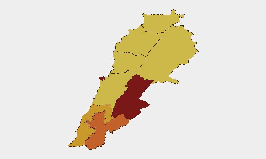
Situation Summary
Lebanon faces acute multi-vector security pressure as of 25 June 2026, with conventional military exchanges involving Israeli and Syrian forces, internal Lebanese military activity, and reported ceasefire violations concentrated in southern and eastern regions. GeoBit's composite threat ranking places Lebanon at position #8 globally (score 100), with 176 tracked events. The security environment shows escalating rather than de-escalating signals across the past 72 hours, driven primarily by cross-border military activity and internal instability.
Key Developments
- Nabatieh al-Fawqa (South Governorate), date unclear from available sources: Israeli forces fatally shot two individuals near a bulldozer conducting road-clearance operations; Lebanon's health ministry confirmed deaths and Hezbollah characterized the incident as a ceasefire breach.
- South Lebanon generally, 22–24 June: Multiple conventional military force events recorded involving Lebanese, Israeli, and Syrian actors; Israeli military reported a separate strike targeting armed militants north of the security zone with unconfirmed casualty figures.
- National level, 22–25 June: Escalating demand signals issued by Lebanese authorities (25 June) and Israeli appeals (24 June); physical assault incident involving Syrian nationals recorded (22 June); media pressure on Lebanese government recorded (23 June).
- Business-sector incident, 24 June: Conventional military force event flagged involving business operations and Lebanese territory; specifics require clarification via direct intelligence feed.
- Switzerland-Lebanon cross-border signal, 22 June: Conventional military force event recorded; likely humanitarian or diplomatic context but requires corroboration.
Intelligence gap note: Available open-source results do not contain sufficient independently corroborated, time-stamped incidents from the final 24–48 hours (24–25 June) to populate a full operational brief at the specificity corporate security teams require. A real-time feed search or Telegram/X OSINT sweep would materially improve event clarity.
Highest-Risk Areas
Beqaa Governorate (risk 100) remains the critical flashpoint, followed closely by Beirut Governorate (81.2) and Nabatieh (74.4). The Beqaa's dominance reflects its role as a cross-border zone vulnerable to Syrian and Israeli military activity, as well as its proximity to non-state armed actors. Nabatieh's ranking reflects the recent ceasefire-violation incident and ongoing southern-border tension. Beirut's elevated risk (81.2) indicates capital-level political instability, potential civil unrest, and secondary effects of regional military pressure. North Governorate, Akkar, and Keserwan-Jbeil all register at 70 and warrant monitoring for secondary spillover from Beqaa activity.
How GeoBit Would Assist
AOI Monitoring & Early Warning with persistent watch on Beqaa Valley, southern border zones (Nabatieh, South), and Beirut would deliver sub-24-hour alert capability on military movements and ceasefire breaches. Conflict & Military battle-mapping and force-structure tracking would clarify Israeli, Syrian, Lebanese, and non-state actor disposition and intent. OSINT fusion (Telegram, X, multi-language local media, YouTube) cross-checked against Satellite & Imagery analysis would close the current gap on precise incident timing and casualty figures, enabling rapid duty-of-care escalation for corporate teams in the capital and eastern regions.
7-Day Outlook
Military tension is expected to remain elevated through early July unless a formal ceasefire mechanism is restored. Beqaa and southern regions carry sustained high risk for cross-border exchanges. Beirut and Mount Lebanon remain vulnerable to secondary economic, political, and civil-order deterioration if military incidents proliferate or if political actors exploit instability for factional gain.
Highest-Risk Areas — Ranked
| # | State / Region | Risk |
|---|---|---|
| 1 | Beqaa Governorate | 100 |
| 2 | Beirut Governorate | 81.2 |
| 3 | Nabatieh Governorate | 74.4 |
| 4 | South Governorate | 71.5 |
| 5 | Mount Lebanon Governorate | 70.7 |
| 6 | North Governorate | 70 |
| 7 | Akkar Governorate | 70 |
| 8 | Keserwan-Jbeil Governorate | 70 |
| 9 | Baalbek-Hermel Governorate | 70 |
Sources
Previous Daily Briefs
A new Lebanon brief is written every day — each with its own risk map and downloadable CSV. Here's the last week; use the calendar to go further back.
📅 Browse every day by calendar →
Highlighted days have a brief. Tap a day for that day's map & analysis, or “csv” for that day's dataset ($5).