Situation Summary
Lesotho remains a low-ranked global threat environment (composite score 6), but faces acute near-term operational risk from severe weather and cross-border disruption. As of 4 August 2026, a major border crossing has closed due to snowfall, disrupting regional logistics and travel. The government is mobilizing disaster preparedness infrastructure across all districts, with heightened coordination between emergency, security, and local authorities; cyber and digital resilience mechanisms are also newly operational.
Key Developments
- Qacha's Nek Port of Entry (Lesotho–South Africa border, southern region) – 4 August 2026: The Border Management Authority temporarily suspended operations due to heavy snowfall rendering travel unsafe for staff and travellers, disrupting cross-border movement near Matatiele. Regional trucking and travel accounts report stranded vehicles and rerouting advisories.
- Southern Lesotho border corridor – 4 August 2026: Following Qacha's Nek closure, authorities escalated weather and infrastructure monitoring at other Lesotho–South Africa crossings, with staffing adjustments in place and advisory notices issued for possible short-notice restrictions if conditions deteriorate.
- Nationwide disaster preparedness campaign – 4 August 2026: The government launched or expanded coordinated emergency response drills and early-warning system deployment, involving disaster agencies, local councils, healthcare, and security personnel. Official announcements emphasize risk mitigation ahead of severe weather season.
- Community-level emergency training (Maseru and district capitals) – 4 August 2026: Authorities initiated awareness sessions on climate hazards and emergency procedures, with increased visible presence of emergency and security personnel in urban and rural areas for drills and public engagement.
- LesCom CSIRT and National Cybersecurity Forum activation – 4 August 2026: The Ministry of Information Communications, Science, Technology and Innovation announced full operational status of Lesotho's Computer Security Incident Response Team and cybersecurity forum, with active awareness campaigns underway.
Highest-Risk Areas
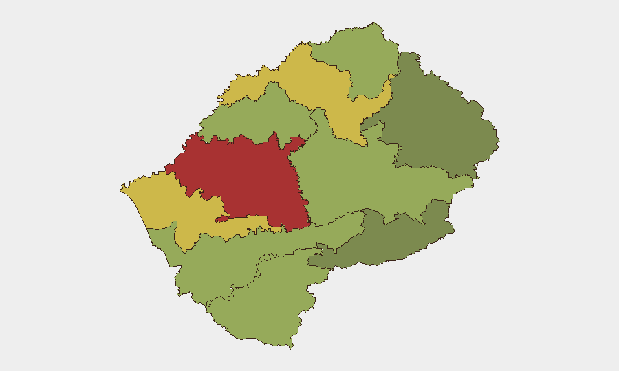
Maseru District (risk 78) and Mafeteng District (risk 65) drive the national risk profile, reflecting concentration of economic activity, population, and administrative infrastructure in these urban and peri-urban zones. Leribe, Berea, and Mohale's Hoek districts (risk scores 62–52) form a secondary tier of elevated vulnerability, likely linked to cross-border connectivity, informal settlements, and service-delivery gaps. Southern border districts (Qacha's Nek, Quthing) show lower baseline scores but face acute seasonal weather risk, evidenced by the current Qacha's Nek closure; northern highlands (Thaba-Tseka, Mokhotlong) remain structurally remote but stable.
How GeoBit Would Assist
Security teams in Lesotho should employ AOI Monitoring & Early Warning to track weather, border operations, and emergency agency activity across Maseru and Mafeteng districts in real time, with alerting configured for closure announcements and staffing changes at priority crossings. Intel Sweep and OSINT fusion (X/Twitter, local news, and agency channels) enable rapid corroboration of travel disruptions and government response posture, reducing false-alarm overhead. Routing & Network Analysis provides alternative border-crossing and in-country logistics pathways when primary corridors (such as Qacha's Nek) close, supporting supply-chain and personnel-movement continuity.
7-Day Outlook
Heavy snow and weather-related border disruptions are expected to persist or recur, with additional crossings at risk if conditions spread northward. Government emergency coordination and public awareness campaigns indicate sustained high operational tempo; corporate teams should anticipate intermittent travel delays, supply-chain friction at southern crossings, and continued visible security/disaster-response presence in urban centers. Cyber incident reporting and digital resilience measures will remain in focus as new CSIRT structures mature.
Highest-Risk Areas — Ranked
| # | State / Region | Risk |
|---|---|---|
| 1 | Maseru District | 78 |
| 2 | Mafeteng District | 65 |
| 3 | Leribe District | 62 |
| 4 | Berea District | 58 |
| 5 | Mohale's Hoek District | 52 |
| 6 | Butha-Buthe District | 48 |
| 7 | Thaba-Tseka District | 45 |
| 8 | Quthing District | 42 |
| 9 | Mokhotlong District | 38 |
| 10 | Qacha's Nek District | 28 |
Sources
Previous Daily Briefs
A new Lesotho brief is written every day — each with its own risk map and downloadable CSV. Here's the last week; use the calendar to go further back.
📅 Browse every day by calendar →
Highlighted days have a brief. Tap a day for that day's map & analysis, or “csv” for that day's dataset ($5).
Atlas — our AI intelligence desk — emails them this snapshot personally. Nothing else, no list.