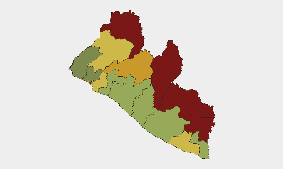
Situation Summary
Liberia maintains a composite national threat score of 7 (rank #129 globally) with no verified acute security incidents in the past 24–48 hours. The security environment remains characterized by persistent sub-national volatility concentrated in the northeastern border counties, where armed-group presence, transnational crime, and weak state capacity create sustained elevated risk. No active civil unrest, armed clashes, infrastructure disruptions, or notable crime spikes were confirmed during the current reporting window.
Key Developments
No verified security incidents were identified in Liberia during the 24–48-hour window ending 2026-08-08. OSINT monitoring detected no new violence, civil unrest, armed activity, significant crime events, or transport disruptions requiring immediate duty-of-care escalation.
Background Context (for situational awareness):
- Drug-interdiction activity and transnational-smuggling pressure have been documented throughout July–early August 2026 at Monrovia and Roberts International Airport, reflecting ongoing regional trafficking.
- Bong County and Monrovia crime reporting from August 3–5 reflects baseline operational policing; no spike or exceptional incident was cross-confirmed.
- A 10-year national security strategy and prior investigative work remain active policy frameworks, but no new executive action or threat directive was issued in the past 48 hours.
Highest-Risk Areas
Nimba, Lofa, Grand Gedeh, and River Gee counties (composite risk scores 92, 88, 85, and 83 respectively) dominate the threat landscape and are geographically clustered in the northeastern border region with Guinea and Côte d'Ivoire. These areas are characterized by porous borders, limited state administrative presence, transnational criminal networks, and historical armed-group activity. Bong County (risk 72) and Gbarpolu County (risk 68) represent a secondary risk tier linked to internal trafficking routes and resource-extraction zones. By contrast, Montserrado County (risk 64), which includes the capital Monrovia, ranks eighth; baseline crime and gang activity persist but remain substantially lower in severity and frequency than northeastern counties.
Corporate personnel and supply chains operating in Nimba, Lofa, or Grand Gedeh counties face materially elevated exposure and should maintain heightened situational awareness and contingency protocols.
How GeoBit Would Assist
Teams with operations or assets in Liberia should employ AOI Monitoring & Early Warning to establish persistent watch over high-risk counties (Nimba, Lofa, Grand Gedeh) with automated alerting for emerging armed activity, civil unrest, or crime escalation. Network & Actor Analysis and multi-language OSINT (including X/Twitter, Telegram, and local-language news monitoring) enable near-real-time tracking of transnational criminal and armed-group movements across the Guinea–Liberia–Côte d'Ivoire border. Routing & Network Analysis supports alternative journey planning and supply-chain rerouting during periods of heightened volatility in specific counties.
7-Day Outlook
No imminent catalysts for acute escalation are evident. Baseline sub-national volatility in northeastern counties is expected to persist, with transnational crime and border-region instability remaining the primary risk drivers. Continued monitoring of Monrovia gang activity and drug-enforcement operations is warranted but is not expected to generate widespread disruption to international business or travel corridors in the near term.
Highest-Risk Areas — Ranked
| # | State / Region | Risk |
|---|---|---|
| 1 | Nimba County | 92 |
| 2 | Lofa County | 88 |
| 3 | Grand Gedeh County | 85 |
| 4 | River Gee County | 83 |
| 5 | Bong County | 72 |
| 6 | Gbarpolu County | 68 |
| 7 | Grand Kru County | 65 |
| 8 | Montserrado County | 64 |
| 9 | Rivercess County | 58 |
| 10 | Sinoe County | 55 |
| 11 | Margibi County | 52 |
| 12 | Grand Bassa County | 48 |
Sources
Previous Daily Briefs
A new Liberia brief is written every day — each with its own risk map and downloadable CSV. Here's the last week; use the calendar to go further back.
📅 Browse every day by calendar →
Highlighted days have a brief. Tap a day for that day's map & analysis, or “csv” for that day's dataset ($5).
Atlas — our AI intelligence desk — emails them this snapshot personally. Nothing else, no list.