Situation Summary
Mauritania remains a low-intensity, fragmented-threat environment with no verified armed clashes, attacks, or major infrastructure incidents in the last 24–48 hours. Recent security signals cluster around political pressure on opposition figures, a vehicular-assault allegation against a high-profile activist, and sustained cyber-threat activity across government and critical infrastructure. The security posture is characterized by localized judicial and political risk in the capital, elevated but non-acute threat activity in the Saharan north and east, and endemic road-safety hazards on major inter-city routes.
Key Developments
- Nouakchott (capital) – 2026-07-29 / Wednesday: Court of Appeal reduced prison sentences for opposition MPs Mariem Mint Cheikh and Ghamou Achour from four to two years, while imposing a five-year ban on their civil and political rights. Reflects ongoing judicial pressure on opposition political actors and long-term exclusion from democratic participation.
- Nouadhibou (north-west) – Last 24–48 hours: Rights group IRA reported that its leader and MP Biram Ould Dah Ould Abeid was targeted in an alleged attempted vehicular ramming by a civilian vehicle allegedly affiliated with police. If confirmed, indicates targeted intimidation against a high-profile activist and possible tensions between security forces and civil-rights advocates.
- Nouakchott–Atar road (between capital and Adrar region) – Last 24–48 hours: Tiris Zemmour governor Idrissa Demba Korera sustained light injuries in a traffic accident; transported to Atar hospital. Highlights road-safety hazards on a major inter-city transit corridor.
- Nationwide – Cyber domain (reported in last 24–48h cycle): PAFIID programme disclosed detection of over 10,000 cyber-security threats during the first half of 2026, with 470 confirmed and removed. Points to sustained, elevated cyber-threat activity targeting national infrastructure and government systems.
- Nouakchott – Security-force discipline: National Guard commander and deputy commander responsible for protecting former president Mohamed Ould Abdel Aziz were arrested and referred for internal disciplinary measures. Indicates intra-security-force tensions linked to elite protection protocols.
- Nationwide – Supply-chain enforcement: Ministry of Trade and Tourism seized 42 tons of expired food products over three days, including 1 ton removed in the last 24 hours, and destroyed the goods. Administrative action affecting market compliance; no civil unrest reported.
Highest-Risk Areas
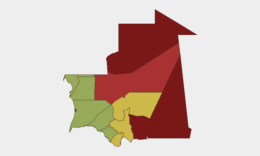
Tiris Zemmour (risk 95) and Hodh Ech Chargui (risk 85) dominate the sub-national threat landscape, followed by Hodh El Gharbi, Adrar, and Tagant. These eastern and north-eastern regions are driven by a combination of cross-border trafficking networks, militant activity linked to regional jihadist groups, ungoverned space, and limited state capacity. Coastal and central regions (Dakhlet Nouadhibou, Brakna, Trarza) exhibit lower risk but remain vulnerable to maritime smuggling and localized crime. The capital and immediate surroundings carry political-volatility and targeted-opposition-figure risks, not large-scale armed threat.
How GeoBit Would Assist
Corporate and risk teams operating in Mauritania should leverage Intel Sweep and multi-language OSINT feeds to monitor opposition-figure movements and judicial proceedings in real time; AOI Monitoring & Early Warning for persistent watch over Tiris Zemmour and Hodh Ech Chargui border zones; and Routing & Network Analysis to identify safer inter-city transit corridors and avoid high-accident-rate roads. Cyber-risk teams should apply entity extraction and cyber-threat feeds to track reported infrastructure vulnerabilities identified by PAFIID.
7-Day Outlook
No imminent armed conflict or mass unrest is anticipated. Political pressure on opposition figures will likely persist as judicial proceedings continue, and road-safety incidents remain endemic. Cyber-threat activity will continue at current elevated levels; teams should expect routine phishing, malware, and infrastructure-targeting probes across government and business systems.
Highest-Risk Areas — Ranked
| # | State / Region | Risk |
|---|---|---|
| 1 | Tiris Zemmour | 95 |
| 2 | Hodh Ech Chargui | 85 |
| 3 | Hodh El Gharbi | 80 |
| 4 | Adrar | 78 |
| 5 | Tagant | 68 |
| 6 | Guidimaka | 65 |
| 7 | Assaba | 62 |
| 8 | Gorgol | 58 |
| 9 | Trarza | 55 |
| 10 | Inchiri | 52 |
| 11 | Brakna | 48 |
| 12 | Dakhlet Nouadhibou | 45 |
Sources
Previous Daily Briefs
A new Mauritania brief is written every day — each with its own risk map and downloadable CSV. Here's the last week; use the calendar to go further back.
📅 Browse every day by calendar →
Highlighted days have a brief. Tap a day for that day's map & analysis, or “csv” for that day's dataset ($5).
Atlas — our AI intelligence desk — emails them this snapshot personally. Nothing else, no list.