Situation Summary
The Philippines faces a composite threat environment of moderate global rank (51st, score 35) characterized by intersecting political unrest, seismic disruption, and persistent maritime tension in disputed waters. Metro Manila and the Cordillera Administrative Region are the primary risk drivers, with demonstrations escalating around geopolitical issues and natural-disaster recovery compounding operational hazard. Near-term outlook indicates sustained civil disorder risk and continued Mindanao-based terrorism threat alongside infrastructure vulnerability from recent seismic activity.
Key Developments
- 12 June 2026 – Metro Manila (Roxas Boulevard): Hundreds of left-wing activists (BAYAN and affiliated groups) breached police barricades at a U.S. Embassy Independence Day protest, demanding removal of U.S. military personnel and an end to EDCA (Enhanced Defense Cooperation Agreement) expansion. Riot police deployed to contain the breach; no casualty reports at this time.
- 14 June 2026 – Mindanao (multiple provinces): Philippine authorities and foreign missions confirmed ongoing aftershocks and structural damage following the 8 June 7.8-magnitude earthquake. Coastal areas maintain elevated tsunami risk; PHIVOLCS/NDRRMC advisories remain active for infrastructure avoidance and evacuation-route compliance.
- 14 June 2026 – Sulu Archipelago & western Mindanao: Updated travel advisories reiterated "advise against all travel" status due to persistent terrorist activity and armed clashes between government forces and insurgent groups. Kidnapping, roadblock, and checkpoint risks remain acute.
- 14 June 2026 – Metro Manila & major urban centers: Forward-looking advisory warns of large-scale demonstrations expected in the coming weeks, with anticipated disruption to government buildings, major roads, and commercial districts. Road closures and police deployments expected; travelers advised to allow extra time and avoid large gatherings.
- Past week – Scarborough Shoal (West Philippine Sea, ~140 miles west of Luzon): Philippine coast guard and U.S. officials confirmed ongoing presence of a Chinese floating "scientific" structure with antenna system inside the shoal. Aerial surveillance confirms platform remains in place; maritime-incident risk elevated in contested waters.
- 14 June 2026 – International airports & air routes: Middle East escalation causing widespread flight disruptions and cancellations on regional transits. Commercial departures from Philippines remain available but itineraries subject to short-notice change.
Highest-Risk Areas
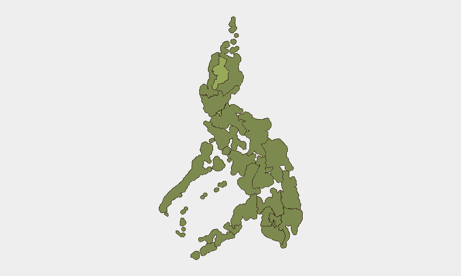
Metro Manila (54.6) and the Cordillera Administrative Region (51.4) drive the bulk of national risk, reflecting urban protest activity, large expatriate and business concentrations, and geopolitical friction over U.S. military presence. Mindanao-based regions (Soccsksargen 31, Zamboanga Peninsula 25.9, Northern Mindanao 24.6) remain persistently threatened by terrorism, armed insurgency, and post-quake infrastructure fragility. Calabarzon (31) and Mimaropa (32.3) face secondary risk from broader demonstration spillover and supply-chain disruption tied to seismic and civil-order factors.
How GeoBit Would Assist
Security teams operating in the Philippines should employ AOI Monitoring & Early Warning on Metro Manila, Cordillera, and Mindanao flashpoints to detect emerging protest mobilization and militant activity in real time. Maritime & Aviation tracking combined with GIS & Spatial Analysis enables monitoring of West Philippine Sea tensions and Scarborough Shoal incidents, while event-feed and OSINT fusion across social media, local news, and government channels provides early indication of demonstration timing and scale. Routing & Network Analysis allows operational teams to plan transport contingencies around anticipated road closures and seismic-damage zones.
7-Day Outlook
Demonstration risk in Metro Manila will likely intensify around geopolitical grievances over U.S. military cooperation, with secondary disruption spreading to major commercial and government districts. Mindanao security posture remains unchanged—continued terrorist activity and infrastructure degradation from seismic damage will constrain travel and operations through at least mid-to-late June. International flight delays tied to Middle East escalation are expected to persist.
Highest-Risk Areas — Ranked
| # | State / Region | Risk |
|---|---|---|
| 1 | Metro Manila | 54.6 |
| 2 | Cordillera Administrative Region | 51.4 |
| 3 | Mimaropa | 32.3 |
| 4 | Soccsksargen | 31 |
| 5 | Calabarzon | 31 |
| 6 | Ilocos Region | 28.5 |
| 7 | Central Luzon | 27.2 |
| 8 | Zamboanga Peninsula | 25.9 |
| 9 | Western Visayas | 25.9 |
| 10 | Bangsamoro | 24.6 |
| 11 | Caraga | 24.6 |
| 12 | Northern Mindanao | 24.6 |
Previous Daily Briefs
A new Philippines brief is written every day — each with its own risk map and downloadable CSV. Here's the last week; use the calendar to go further back.
📅 Browse every day by calendar →
Highlighted days have a brief. Tap a day for that day's map & analysis, or “csv” for that day's dataset ($5).