Situation Summary
Saint Lucia remains a moderate-risk environment (global rank #154, composite score 6) with concentrated urban violence centered in the capital and northern parishes. Five homicides and multiple violent incidents were recorded in mid-August 2026, with approximately 45 homicides year-to-date (73% firearm-related), indicating persistent gang and interpersonal violence. No specific security incidents have been corroborated for the last 24–48 hours (21–22 August); however, the underlying threat environment—driven by illicit drug activity, territorial disputes, and firearm availability—remains active across high-risk districts.
Key Developments
No corroborated incidents within the last 24–48 hours (21–22 August 2026) were identified through open-source media, official police releases, or multi-source verification. The most recent documented events are from mid-August (12–17 August):
- 2026-08-17, Belair & Ravine Chabot (Castries): Two men shot dead in separate incidents within hours; Royal Saint Lucia Police Force and Major Crimes Unit responded.
- 2026-08-15, Vanard community: Shooting reported; male victim treated for penetrating injuries.
- 2026-08-12, Unionville, Choiseul: Water infrastructure tampering detected on WASCO transmission main; investigation ongoing.
Trend context (since 1 January 2026): 45 homicides recorded islandwide; 73% firearm-related. This reflects elevated but relatively stable violence compared to prior years, concentrated in urban parishes.
*Note: Ongoing monitoring of police press releases, local media outlets (HTS, St. Lucia Times, DBS, Choice TV), and geo-targeted X/Twitter feeds is required to capture same-day or next-day incident corroboration. Current reporting lag and source availability limit same-day brief confidence.*
Highest-Risk Areas
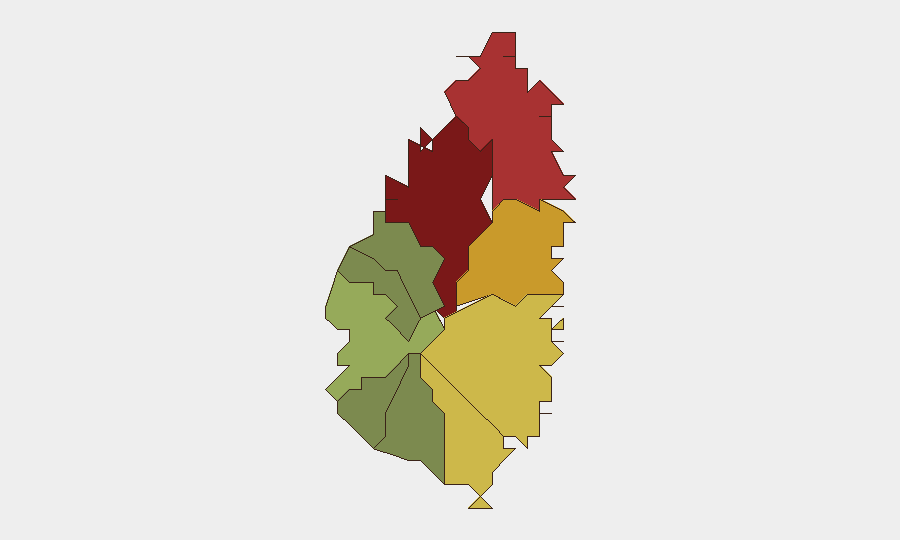
Castries (risk 95) is the dominant threat driver, accounting for the majority of recorded homicides and violent incidents; Belair, Ravine Chabot, and surrounding neighborhoods remain flashpoints for gang and interpersonal violence. Gros Islet (78) and Dennery (72) follow as secondary hotspots, with Dennery showing consistent mid-range risk linked to drug distribution networks and border-adjacent activities. Vieux Fort (68) and Micoud (65) present emerging concerns, likely tied to maritime trafficking routes and rural gang activity. Parishes south and west of the capital—Soufrière, Laborie, Choiseul, and Canaries—show substantially lower risk, although infrastructure tampering (e.g., WASCO valve tampering in Choiseul) signals potential non-traditional threats.
How GeoBit Would Assist
AOI Monitoring & Early Warning would establish persistent watch over Castries, Gros Islet, and Dennery, with alerting thresholds for police incidents, social-media violence indicators, and infrastructure reports. Intel Sweep and X/Twitter OSINT would enable 24–48 hour incident capture, gang-actor network mapping, and sentiment tracking to forecast escalation. Risk & Threat Assessment and GIS & Spatial Analysis would allow corporate teams to model safe routing, assess asset exposure by parish, and plan duty-of-care evacuations or protective measures for personnel in high-risk zones.
7-Day Outlook
Violence is forecast to remain at mid-August baseline levels (2–4 incidents per week islandwide) absent significant gang truce breakdown or police enforcement surge. The transition into the Caribbean hurricane season (August–October) may cause temporary reporting delays and redirect police resources, potentially obscuring trend clarity. Corporate security teams should maintain elevated alert status for Castries-based personnel and implement geo-fencing alerts for facilities in Castries, Gros Islet, and Dennery.
Highest-Risk Areas — Ranked
| # | State / Region | Risk |
|---|---|---|
| 1 | Castries | 95 |
| 2 | Gros Islet | 78 |
| 3 | Dennery | 72 |
| 4 | Vieux Fort | 68 |
| 5 | Micoud | 65 |
| 6 | Soufrière | 42 |
| 7 | Laborie | 38 |
| 8 | Choiseul | 35 |
| 9 | Anse La Raye | 28 |
| 10 | Canaries | 12 |
Sources
Previous Daily Briefs
A new Saint Lucia brief is written every day — each with its own risk map and downloadable CSV. Here's the last week; use the calendar to go further back.
- August 20, 2026
- August 18, 2026
- August 16, 2026
- August 14, 2026
- August 12, 2026
- August 10, 2026
- August 8, 2026
📅 Browse every day by calendar →
Highlighted days have a brief. Tap a day for that day's map & analysis, or “csv” for that day's dataset ($5).
Atlas — our AI intelligence desk — emails them this snapshot personally. Nothing else, no list.