Situation Summary
Samoa maintains a stable security baseline with no reportable incidents in the past 24–48 hours. The country ranks #83 globally on GeoBit's composite threat index (score 21) with zero tracked active events. Petty crime in urban Apia and standard small-island vulnerabilities (limited medical capacity, weather exposure) remain the primary baseline risks; no indicators of organized violence, civil unrest, or political instability are evident in current open-source reporting.
Key Developments
No confirmed security, crime, unrest, infrastructure, or travel-risk incidents have been identified in Samoa in the last 24–48 hours as of 2026-09-02. The most recent Samoa-specific security assessment (2026-08-27) reported a stable security posture with only routine petty crime activity in Apia and no deterioration in the preceding window. Current monitoring shows no active alerts from national police, disaster management, aviation/maritime authorities, or major Pacific regional news outlets for this period.
Highest-Risk Areas
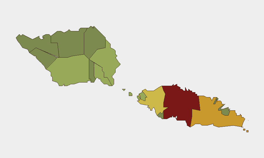
Tuamasaga (risk 85) and Ātua (risk 71) are the two highest-risk districts and together account for disproportionate exposure within Samoa. Tuamasaga, home to the capital Apia, concentrates urban petty crime (theft, opportunistic robbery), higher population density, and infrastructure dependency; Ātua follows with elevated baseline risk but lower incident frequency. The remaining nine districts (Aʻana through Vaisigano) decline in risk score, with outer and rural regions showing substantially lower composite threat levels. For corporate personnel and assets, Tuamasaga merits elevated duty-of-care protocols; Ātua requires standard precautions aligned with its mid-level rank.
How GeoBit Would Assist
Intel Sweep and multi-language OSINT monitoring of Samoan police channels, government statements, and Pacific news feeds enable real-time detection of any security shifts, crime spikes, or infrastructure disruptions. AOI Monitoring & Early Warning can establish persistent watch over Apia's central business and port districts, with automated alerting if civil unrest, labor actions, or significant crime clusters emerge. GIS & Spatial Analysis overlaid with current sub-national risk rankings allows security teams to route personnel and supply chains away from highest-risk zones (Tuamasaga, Ātua) and identify safer transit corridors, while Maritime & Aviation tracking can provide visibility on port and airport disruptions that might trap or delay corporate movements.
7-Day Outlook
No indicators suggest deterioration over the next seven days. Samoa's political and judicial systems are functioning routinely with no scheduled major events, unrest signals, or weather alerts (outside normal seasonal cyclone season preparedness). Baseline risk posture is expected to remain stable; security teams should maintain standard petty-crime precautions in Apia and continue routine monitoring for any sudden policy, labor, or weather developments that could affect operations.
Highest-Risk Areas — Ranked
| # | State / Region | Risk |
|---|---|---|
| 1 | Tuamasaga | 85 |
| 2 | Ātua | 71 |
| 3 | Aʻana | 62 |
| 4 | Aiga-i-le-Tai | 55 |
| 5 | Faʻasaleleaga | 48 |
| 6 | Palauli | 42 |
| 7 | Satupaʻitea | 38 |
| 8 | Gagaʻemauga | 35 |
| 9 | Gagaʻifomauga | 32 |
| 10 | Vaisigano | 28 |
| 11 | Vaʻa-o-Fonoti | 23 |
Sources
Previous Daily Briefs
A new Samoa brief is written every day — each with its own risk map and downloadable CSV. Here's the last week; use the calendar to go further back.
- August 31, 2026
- August 29, 2026
- August 27, 2026
- August 25, 2026
- August 23, 2026
- August 21, 2026
- August 19, 2026
📅 Browse every day by calendar →
Highlighted days have a brief. Tap a day for that day's map & analysis, or “csv” for that day's dataset ($5).
Atlas — our AI intelligence desk — emails them this snapshot personally. Nothing else, no list.