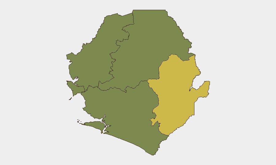
Situation Summary
Sierra Leone remains a low-threat environment globally (rank #132, composite score 9) with no confirmed security incidents or civil unrest reported in the last 24–48 hours as of 30 August 2026. Risk is heavily concentrated in the Eastern Province (score 68), where localized vulnerabilities persist, while the Western Area (score 35) and remaining provinces show minimal current threat signals. The overall security trajectory remains stable absent new triggering events, though underlying structural vulnerabilities in dispute resolution, informal mining, and protest management warrant continued monitoring.
Key Developments
No discrete security or unrest events have been reliably confirmed for 29–30 August 2026.
Recent activity from late August (outside the strict 24–48h window but potentially operationally relevant):
- Waterloo / Madonkeh, Western Area (~25 Aug): Land-dispute killing of an OSD police officer; underlying dispute dynamics remain unresolved and could re-escalate.
- Freetown, Western Area (planned for 26 Aug, notice issued 20 Aug): Citizens Advocacy Network protest over constitutional amendments was subject to police restrictions; post-event outcome unclear from available sources.
- Waterloo Court, Western Area (~28 Aug): Arrest of individual fraudulently posing as lawyer for five years; reflects gaps in institutional oversight but no direct security threat.
- Outamba-Kilimi National Park, Northern Province (~28 Aug): Security forces arrested 17 individuals for illegal mining; indicates enforcement activity but no armed resistance reported.
Verification note: These events fall outside the 24–48-hour window specified above. No confirmed incidents dated 29–30 August 2026 are available from open sources at this time.
Highest-Risk Areas
Eastern Province (score 68) is the primary driver of national risk and warrants priority monitoring. The province's elevated score reflects a combination of historical vulnerabilities—including resource-dispute dynamics, informal-sector tensions, and limited state capacity—that create conditions for localized violence, particularly around land and mining.
Western Area (score 35), home to Freetown and the capital region, shows secondary risk from institutional friction (police-protest management, land disputes in peri-urban zones like Waterloo) and transactional crime. The remaining three provinces (Northern, North West, Southern) show minimal tracked signals.
Organizations with personnel or operations in Eastern Province should maintain heightened situational awareness; Western Area risk is manageable with standard duty-of-care protocols.
How GeoBit Would Assist
AOI Monitoring & Early Warning can establish persistent watches on Eastern Province and dispute hotspots (Madonkeh, mining zones) with automated alerting for new incidents or escalation indicators. OSINT Fusion & Corroboration (X/Twitter, Telegram, local news feeds, multi-language search) enables rapid verification of emerging reports and distinction between rumors and confirmed events—critical given the sparse 24–48-hour incident data. Network & Actor Analysis can map relationships among police, protest organizers, land-dispute parties, and informal mining operators to identify flashpoint actors and early warning signals for escalation.
7-Day Outlook
No major destabilizing events are anticipated in the immediate term. The constitutional amendment debate and land-dispute friction remain live underlying issues, but absent significant political or economic shocks, the security environment is likely to remain broadly stable. Continued monitoring of Eastern Province and dispute-resolution outcomes in Waterloo is prudent given historical volatility in those zones.
Highest-Risk Areas — Ranked
| # | State / Region | Risk |
|---|---|---|
| 1 | Eastern Province | 68 |
| 2 | Western Area | 35 |
| 3 | North West Province, Sierra Leone | 0 |
| 4 | Northern Province, Sierra Leone | 0 |
| 5 | Southern Province, Sierra Leone | 0 |
Sources
Previous Daily Briefs
A new Sierra Leone brief is written every day — each with its own risk map and downloadable CSV. Here's the last week; use the calendar to go further back.
- August 28, 2026
- August 26, 2026
- August 24, 2026
- August 22, 2026
- August 19, 2026
- August 17, 2026
- August 15, 2026
📅 Browse every day by calendar →
Highlighted days have a brief. Tap a day for that day's map & analysis, or “csv” for that day's dataset ($5).
Atlas — our AI intelligence desk — emails them this snapshot personally. Nothing else, no list.