Situation Summary
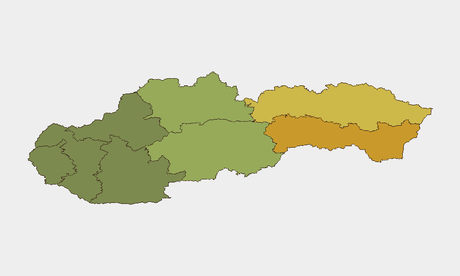
Slovakia remains a low-threat environment overall (composite threat score 4; no tracked discrete security incidents in the current assessment window). However, significant geographic variance exists: eastern regions, particularly Košice and Prešov, carry markedly elevated risk profiles (72 and 68 respectively), while western and central areas remain considerably safer. The country faces no active conflict, major terrorism threat, or widespread civil unrest at present, though regional vulnerability patterns warrant targeted monitoring.
Key Developments
- Bratislava, 2026-08-03: Slovak police initiated a criminal investigation into the death of Olympian Denisa Hurban Baránková following an accident in Petržalka. Status remains under investigation; no charges or additional incident reports have emerged in the 24–48 hour window.
- National level, 2026-08-05: Slovakia suspended Schengen visa issuance for Russian citizens, with limited exceptions for athletes and certain national-visa categories during July–August 2026. This policy shift reflects border-control posture but does not signal an immediate security incident within Slovakia.
- Western Slovakia (Kamenica nad Hronom, Skalica), 2026-08-05: Record heat warnings were issued as temperatures reached 41.4°C in Kamenica nad Hronom and near-record overnight temperatures were recorded in Skalica. While meteorological rather than a security incident, extreme heat poses infrastructure stress, travel delays, and public-health risk across transport and utility networks.
- Bratislava, 2026-08-05: Government-opposition statements cited a Russian missile incident in Poland as a bilateral concern. This is a foreign event and does not constitute a Slovakia-based security development, though it reflects political attention to regional military activity.
- Eastern Slovakia regions: No discrete 24–48 hour incidents reported, but Košice and Prešov regions maintain the highest sub-national risk scores (72 and 68), indicating cumulative vulnerability factors warranting continued surveillance.
Highest-Risk Areas
Eastern Slovakia—specifically Košice (risk 72) and Prešov (risk 68)—substantially outpace all other regions and drive the national risk profile. Banská Bystrica (55) and Žilina (42) represent secondary tiers of concern. Western and southwestern regions (Bratislava, Trenčín, Trnava) remain materially lower-risk. The disparity suggests concentrations of organized crime, human trafficking, border-related activity, or socioeconomic fragility in the east; Bratislava, despite being the capital and seat of government, scores only 28, likely reflecting stronger institutional presence and law-enforcement capacity. Teams with personnel or assets in Košice or Prešov should prioritize localized threat briefings and liaison with regional authorities.
How GeoBit Would Assist
Intel Sweep and multi-language OSINT would enable continuous monitoring of Slovak media, social platforms, and regional Telegram channels for emerging unrest, crime spikes, or infrastructure incidents—particularly in Košice and Prešov. AOI Monitoring & Early Warning with persistent geofencing around high-risk regions and critical assets (transport hubs, energy facilities, government offices) would provide real-time alerting if events escalate. Routing & Network Analysis would support contingency journey planning for personnel in eastern regions, identifying safer corridors and alternative routes in case of localized instability.
7-Day Outlook
No imminent security escalation is forecast. Heat stress may persist through mid-August, affecting utility reliability and travel safety; teams should prepare for potential service disruptions in energy and water systems. Eastern regional risk factors remain stable but elevated; continuous monitoring is warranted, though no acute trigger for rapid deterioration is evident in current signals.
Highest-Risk Areas — Ranked
| # | State / Region | Risk |
|---|---|---|
| 1 | Region of Košice | 72 |
| 2 | Region of Prešov | 68 |
| 3 | Region of Banská Bystrica | 55 |
| 4 | Region of Žilina | 42 |
| 5 | Region of Nitra | 35 |
| 6 | Region of Bratislava | 28 |
| 7 | Region of Trenčín | 22 |
| 8 | Region of Trnava | 18 |
Sources
Previous Daily Briefs
A new Slovakia brief is written every day — each with its own risk map and downloadable CSV. Here's the last week; use the calendar to go further back.
📅 Browse every day by calendar →
Highlighted days have a brief. Tap a day for that day's map & analysis, or “csv” for that day's dataset ($5).
Atlas — our AI intelligence desk — emails them this snapshot personally. Nothing else, no list.