Situation Summary
Solomon Islands remains in a stable security posture with no acute incidents reported in the last 24–48 hours. The national composite threat score stands at 7, reflecting a historically low-intensity threat environment. Risk remains concentrated in urban centers, particularly Honiara and Guadalcanal, where underlying vulnerabilities in governance, infrastructure, and inter-community relations persist but are not currently manifesting as active crises.
Key Developments
No discrete security, civil-unrest, crime, or infrastructure incidents have been reported in Solomon Islands in the last 24–48 hours. Open-source monitoring across national news outlets, regional Pacific feeds (ABC Pacific, PACNEWS), government information channels, and security intelligence services confirms the absence of tracked acute events during this window.
*Background context (not current):* Earlier developments from late July included debate over the US shiprider agreement and a fatality associated with the Gold Ridge mine landslide; these events fall outside the current reporting window and do not reflect current conditions.
Highest-Risk Areas
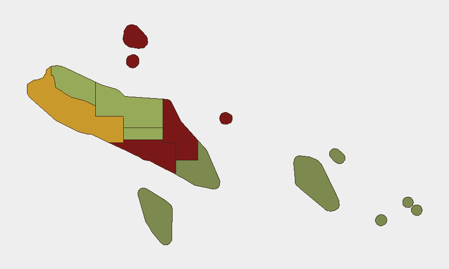
Honiara (risk 92) and Guadalcanal (risk 88) drive the majority of Solomon Islands' measurable risk, followed by Malaita (risk 85). The concentration reflects urbanization, governance capacity gaps, historical inter-community tensions, and infrastructure strain in the capital and surrounding province. Western Province (risk 72) represents a secondary tier of concern. Rural and outer-island provinces (Temotu, Rennell and Bellona, Makira-Ulawa) maintain substantially lower composite scores, indicating reduced operational and security complexity for most corporate or humanitarian activities in those zones.
How GeoBit Would Assist
Corporate security and duty-of-care teams operating in Solomon Islands would deploy AOI Monitoring & Early Warning to establish persistent watch on Honiara and Guadalcanal for early signals of civil unrest, labor action, or infrastructure disruption. Intel Sweep and OSINT fusion capabilities—including X/Twitter & Telegram monitoring, multi-language search, and sentiment analysis—would provide continuous visibility into emerging political or social narratives and actor positioning. Routing & Network Analysis would enable alternative journey planning for staff transiting high-risk urban zones or planning supply-chain movements, while Risk & Threat Assessment modules would support scenario planning for duty-of-care scenarios tied to infrastructure failure or localized unrest.
7-Day Outlook
No imminent acute triggers are evident. The near-term trajectory remains stable unless external shocks (e.g., political appointment disputes, maritime boundary incidents with neighbors, commodity-price volatility affecting mining operations) emerge. Seasonal weather patterns and routine governance cycles are unlikely to generate security escalation within the 7-day window. Continued monitoring of Honiara and Guadalcanal should remain standard practice for any team with material presence.
GEOBIT DAILY SECURITY BRIEF
Solomon Islands | 2026-08-06
Composite Threat Score: 7 | Global Ranking: #null | Tracked Events (24–48h): 0
Highest-Risk Areas — Ranked
| # | State / Region | Risk |
|---|---|---|
| 1 | Honiara | 92 |
| 2 | Guadalcanal | 88 |
| 3 | Malaita | 85 |
| 4 | Western | 72 |
| 5 | Choiseul | 58 |
| 6 | Isabel | 52 |
| 7 | Central Province | 48 |
| 8 | Makira-Ulawa | 38 |
| 9 | Rennell and Bellona | 22 |
| 10 | Temotu | 18 |
Sources
Previous Daily Briefs
A new Solomon Islands brief is written every day — each with its own risk map and downloadable CSV. Here's the last week; use the calendar to go further back.
📅 Browse every day by calendar →
Highlighted days have a brief. Tap a day for that day's map & analysis, or “csv” for that day's dataset ($5).
Atlas — our AI intelligence desk — emails them this snapshot personally. Nothing else, no list.