Situation Summary
Tanzania remains at global threat rank #45 with a composite threat score of 48, reflecting a broadly stable security environment in major urban and business centers. The primary operational risk signal currently is widespread wildfire activity across multiple regions as of 24 June, rather than civil unrest, acute crime, or infrastructure failure. No confirmed incidents of public disorder, criminal spikes, or travel impediments have been detected in the last 48 hours across monitored areas. A Rwanda-linked arrest/detention event on 24 June warrants monitoring for potential border implications, though no direct Tanzania-side impact is confirmed.
Key Developments
- Multiple regions, Tanzania — 2026-06-24: Wildfire activity confirmed across several parts of the country; geographic extent and asset impact are still under assessment, constituting the primary operational risk signal nationally.
- Countrywide — 2026-06-23 to 2026-06-24: No confirmed civil unrest, acute criminal activity, infrastructure failure, or travel impediments reported in major urban and business centers during this 48-hour window.
- Northwestern border area (Tanzania–Rwanda) — 2026-06-24: A Rwanda arrest/detention event flagged by monitoring systems; direct implications for Tanzania remain unclear pending corroboration and further intelligence.
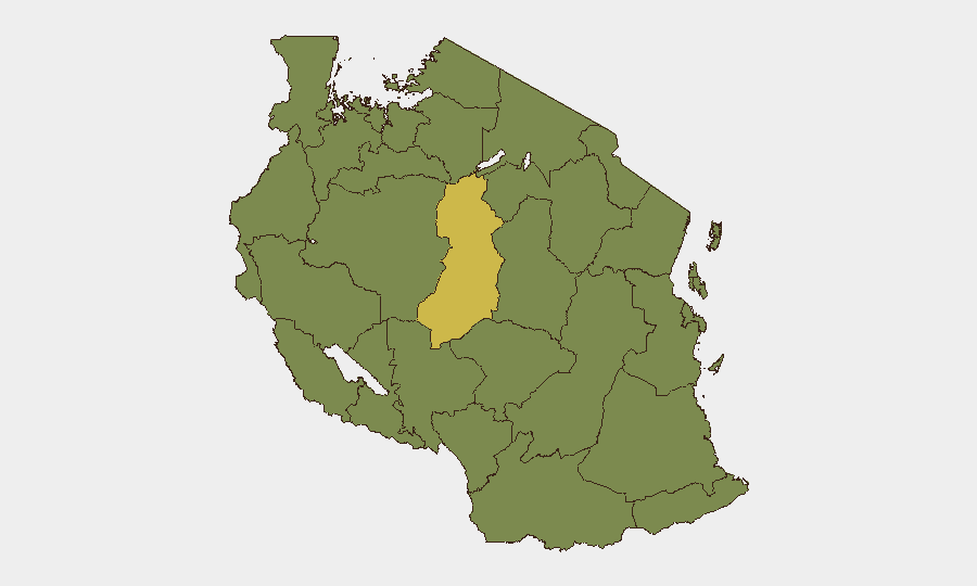
- Singida Region — ongoing: Highest sub-national risk score (63.7) persists, though no acute incidents reported in the immediate past 48 hours.
Highest-Risk Areas
Singida Region significantly exceeds all other zones, with a composite risk score of 63.7—nearly double the second-tier group. The remaining eleven highest-risk regions (Kigoma, Kagera, Mwanza, Geita, Shinyanga, Tabora, Katavi, Rukwa, Songwe, Mara, and Simiyu) cluster at 33.7, reflecting persistent structural vulnerabilities—likely including cross-border activity, resource competition, and limited state capacity—but without acute triggering events in the current 48-hour window. Singida's elevated risk warrants enhanced situational awareness for personnel and asset movements; the second tier should remain on standard monitoring.
How GeoBit Would Assist
A corporate security team with operations in Tanzania should employ AOI Monitoring & Early Warning systems to track Singida and border regions (Kagera, Kigoma) for emerging unrest or infrastructure disruption. Satellite & Imagery analysis would support real-time assessment of wildfire spread, smoke impact on transportation routes, and asset exposure. Routing & Network Analysis capabilities enable identification of alternative travel and supply-chain corridors to bypass fire-affected zones and cross-border friction points, supporting continuity planning and duty-of-care compliance.
7-Day Outlook
Wildfire activity is expected to remain the dominant operational constraint through early July, with meteorological and seasonal factors likely sustaining fire risk in affected regions. No indicators of escalating civil unrest, cross-border military movement, or major infrastructure failure are evident, suggesting the broader security environment will remain stable barring secondary effects (respiratory health, air quality, transport delays) from fire activity. Continued monitoring of the Rwanda border context is advised, particularly if the 24 June detention event generates ripple effects.
Highest-Risk Areas — Ranked
| # | State / Region | Risk |
|---|---|---|
| 1 | Singida Region | 63.7 |
| 2 | Kigoma Region | 33.7 |
| 3 | Kagera | 33.7 |
| 4 | Mwanza Region | 33.7 |
| 5 | Geita | 33.7 |
| 6 | Shinyanga Region | 33.7 |
| 7 | Tabora Region | 33.7 |
| 8 | Katavi Region | 33.7 |
| 9 | Rukwa Region | 33.7 |
| 10 | Songwe Region | 33.7 |
| 11 | Mara Region | 33.7 |
| 12 | Simiyu | 33.7 |
Sources
Previous Daily Briefs
A new Tanzania brief is written every day — each with its own risk map and downloadable CSV. Here's the last week; use the calendar to go further back.
📅 Browse every day by calendar →
Highlighted days have a brief. Tap a day for that day's map & analysis, or “csv” for that day's dataset ($5).