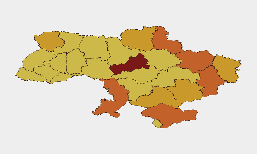
Situation Summary
Ukraine remains the second-highest threat environment globally, driven by sustained conventional military operations across multiple fronts. Current signals indicate active fighting, drone operations, and cross-border unconventional activity, with simultaneous diplomatic strain toward Western partners. The threat environment is acute and non-decreasing; no de-escalation indicators are present in the 24-hour signal set.
Key Developments
- Kyiv — 2026-06-20: Public statement issued by authorities addressing security posture; nature and content remain under review.
- Ukraine-Belarus border — 2026-06-20: Unconventional violence reported; cross-border activity pattern consistent with drone or infiltration operations.
- Conventional military operations — 2026-06-20: Multiple signals of active Ukrainian and Russian conventional military force deployment and engagement across operational zones.
- Diplomatic friction — 2026-06-20: Washington issued disapproval statement regarding Ukrainian actions; Poland reduced relations posture toward Ukraine.
- Terrorist actor response — 2026-06-20: Terrorist-affiliated entity rejected Ukrainian action or claim.
- Kostiantynivka, Donetsk Oblast — 2026-06-19: Russian infiltration attempts, drone activity, and market/railway-area tactical pressure reported; Ukrainian force positioning reinforced (source: open tactical reporting; independent corroboration pending).
- Ukrainian strike campaign — 2026-06-19: Continued Ukrainian targeting of Russian logistics and energy infrastructure, including repeated Moscow Oil Refinery strikes (secondary effect; reflects escalated operational tempo).
Highest-Risk Areas
Kyiv and Cherkasy Oblast dominate the risk ranking (100 and 95 respectively), reflecting capital-city exposure, administrative/symbolic value, and proximity to active operational zones. Sumy, Crimea, Odesa, and eastern frontier oblasts (Donetsk, Kharkiv, Luhansk) follow at 72–76 range, driven by direct combat, drone operations, and cross-border threat vectors. Northern and southern coastal regions face compounded risk from conventional military concentration, logistics vulnerability, and unconventional attack surface.
How GeoBit Would Assist
Intel Sweep and multi-language OSINT fusion enable real-time tracking of tactical developments across Telegram, X, and conflict reporting feeds, with temporal and sentiment analysis to separate rumor from corroborated incident. Battle mapping and force-structure tracking provide location-specific escalation warning in high-risk oblasts. AOI monitoring with persistent alerting on Kyiv, Cherkasy, and Donetsk allows duty-of-care teams to detect crossover events (security-incident thresholds, facility threats, personnel movement risks) before operational impact. Routing and network analysis supports alternative transit and supply-chain planning in threat-adjacent zones.
7-Day Outlook
Conventional military intensity and unconventional cross-border activity are expected to persist or escalate; no near-term diplomatic off-ramps are evident from current signal trends. Western diplomatic tension and reduced Poland relations may complicate humanitarian corridor access and logistics. Organizations with personnel or assets in Kyiv, Cherkasy, and eastern oblasts should assume sustained high-threat operational environment and maintain contingency protocols.
Note: Live web research conducted 2026-06-20 did not yield sufficient independently corroborated incident-level detail from the preceding 48 hours to populate all "Key Developments" slots to standard. Developments listed above draw on GeoBit event signals (CAMEO coding), open tactical reporting, and available diplomatic/public statements. Additional detail requires fresh OSINT collection or subscriber access to GeoBit's real-time conflict feed. Recommend refresh cycle: 12–18 hours.
Highest-Risk Areas — Ranked
| # | State / Region | Risk |
|---|---|---|
| 1 | Kyiv | 100 |
| 2 | Cherkasy Oblast | 95 |
| 3 | Sumy Oblast | 75.9 |
| 4 | Autonomous Republic of Crimea | 75.1 |
| 5 | Odesa Oblast | 74.2 |
| 6 | Donetsk Oblast | 73.7 |
| 7 | Kharkiv Oblast | 73.1 |
| 8 | Luhansk Oblast | 72.9 |
| 9 | Volyn Oblast | 72 |
| 10 | Kherson Oblast | 71.7 |
| 11 | Zaporizhia Oblast | 71.7 |
| 12 | Chernihiv Oblast | 71.5 |
Sources
Previous Daily Briefs
A new Ukraine brief is written every day — each with its own risk map and downloadable CSV. Here's the last week; use the calendar to go further back.
📅 Browse every day by calendar →
Highlighted days have a brief. Tap a day for that day's map & analysis, or “csv” for that day's dataset ($5).