Situation Summary
Vanuatu presents a composite threat score of 5 with three tracked event signals as of 2026-06-23, placing it in the lower-risk category globally. No independently confirmed security incidents, civil unrest, major crime spikes, or infrastructure emergencies have been reported in the past 24–48 hours across open-source news, government advisories, or regional feeds. The most recent event signals (rejection, reduced relations, and threat messaging—all dated 2026-06-20) lack corroboration in independent reporting and do not appear to have triggered observable on-ground incidents or official responses.
Key Developments
- National level – 2026-06-20 – Three event signals logged: rejection, reduction of relations, and threat messaging detected in GeoBit feeds; no corresponding security incident, official statement, or media coverage has been independently confirmed in open reporting.
- Port Vila, Efate – 2026-06-18 – Routine domestic news cycle: VBTC Nius broadcast coverage reflects normal political and social discussion with no reference to unrest, crime surge, or infrastructure emergency.
- Vanuatu (national) – mid-to-late June 2026 – Diplomatic engagement ongoing: National University of Vanuatu participation in the 2026 Pacific Peace and Security Dialogue in Suva proceeds without indication of internal conflict or crisis driving the engagement.
- Regional health context – 2026-06-11 – Dengue activity noted across Pacific: New Zealand SafeTravel advisory lists elevated dengue activity in the broader Pacific region; Vanuatu is not flagged in the most recent alert, and no new outbreak advisory specific to Vanuatu has been issued in the last 48 hours.
- No new travel warnings or advisories: Major travel-advisory bodies (NZL, AUS, regional partners) have not updated Vanuatu guidance in the past 24–48 hours.
Highest-Risk Areas
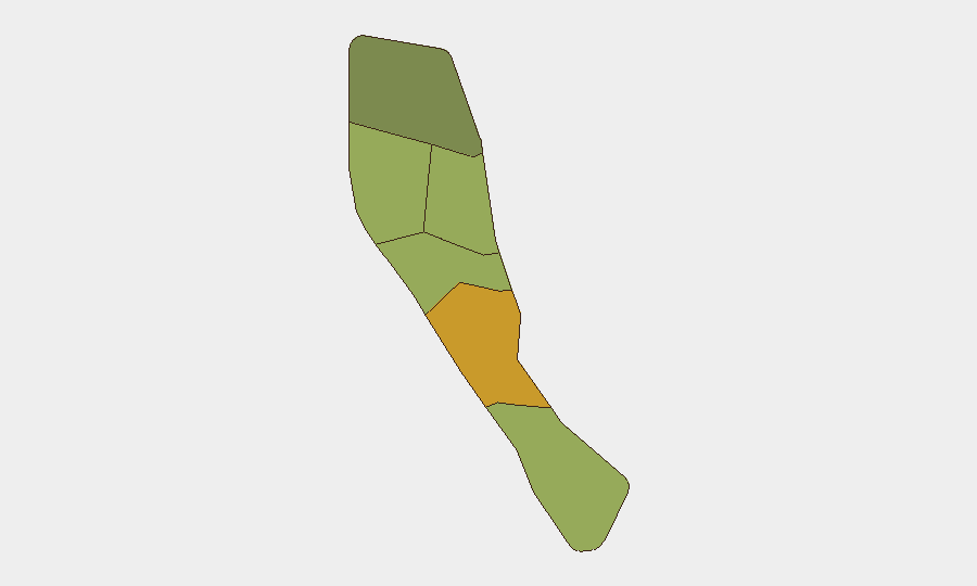
Shefa Province (risk score 72) drives the national composite score and is significantly higher than all other provinces, suggesting concentrated risk factors—likely tied to Port Vila's status as capital, population density, and economic activity. Penama and Sanma provinces rank second and third (58 and 52 respectively), while peripheral regions (Tafea, Torba) register lower scores. The gap between Shefa and the remainder of the country indicates that duty-of-care efforts should prioritize Efate Island and Port Vila proper, while routine monitoring suffices for outer islands. The precise risk drivers (crime, political instability, infrastructure fragility, natural hazard exposure) warrant deeper sub-provincial analysis to refine operational security posture.
How GeoBit Would Assist
Security and risk teams would deploy AOI Monitoring & Early Warning to establish persistent watch on Shefa Province and Port Vila with automated alerting for civil unrest, protest activity, or crime-cluster signals. Intel Sweep and multi-language OSINT fusion across local media, government statements, and social platforms would provide early corroboration of event signals and clarify intent behind the 2026-06-20 threat messaging. Risk & Threat Assessment tools would integrate provincial rankings with real-time incident data to refine duty-of-care decisions for personnel movement and asset protection in high-risk districts.
7-Day Outlook
No imminent security escalation is evident from current open-source intelligence. The 2026-06-20 event signals should be monitored for follow-up statements or ground activity; absence of independent confirmation suggests either limited scope or premature or speculative reporting. Personnel and asset managers should maintain standard situational awareness protocols with heightened attention to Shefa Province and maintain contact with local partners and diplomatic networks for early warning of policy or political shifts.
Highest-Risk Areas — Ranked
| # | State / Region | Risk |
|---|---|---|
| 1 | Shefa Province | 72 |
| 2 | Penama | 58 |
| 3 | Sanma | 52 |
| 4 | Malampa | 48 |
| 5 | Tafea | 45 |
| 6 | Torba | 35 |
Sources
Previous Daily Briefs
A new Vanuatu brief is written every day — each with its own risk map and downloadable CSV. Here's the last week; use the calendar to go further back.
📅 Browse every day by calendar →
Highlighted days have a brief. Tap a day for that day's map & analysis, or “csv” for that day's dataset ($5).