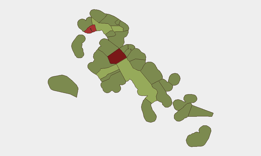
Situation Summary
Bahamas remains a low-threat jurisdiction globally (rank #87, composite score 21), but violent crime in New Providence—particularly Nassau—has intensified sharply over the past seven days, with four fatal shootings and two traffic deaths recorded. Gang-related and retaliatory violence dominates the incident pattern, concentrated in high-density residential neighborhoods and street-level confrontations. Infrastructure disruptions (power outages) and economic stagnation in secondary tourism hubs (Freeport) compound operational risk for corporate assets and personnel, though no systemic security collapse is evident.
Key Developments
- Nassau, Wilson Tract (October 5): A triple shooting resulted in one fatality and two hospitalizations (ages 17, 20); incident characterized as an attempted hit.
- Nassau, Rupert Dean Lane and Dunmore Street (October 7): A 28-year-old man shot and killed outside his residence by a gunman on a moped; police opened murder investigation.
- Nassau, Wilson Tract (October 7): Rapper Yaphet Newton identified as victim of the October 5 triple shooting; reports indicate accidental killing by accomplice during an attempted hit.
- New Providence, multiple locations (October 5–9): Two fatalities recorded in separate traffic accidents; road safety concerns escalated.
- Nassau, Yellow Elder Gardens, Stapledon Gardens, Harold Road, Blue Hill Heights (October 6–7): Extended power outage (6 p.m. to 11:30 a.m. following day) disrupted households and forced school dismissals.
- Nassau, C.C. Sweeting High School (October 7): School closure extended pending electrical inspections following infrastructure upgrades by Bahamas Grid Company and BPL.
- Grand Bahama, Port Lucaya Marketplace (October 6–12): Marina redevelopment stalled; at least one restaurant temporary shutdown affected approximately 40 workers, raising business-closure risk.
Highest-Risk Areas
New Providence (risk 92) and the City of Freeport (risk 78) account for the majority of tracked threat activity. New Providence—home to Nassau and the capital's core commercial and residential districts—continues to experience concentrated gang violence, retaliatory shootings, and street-level firearms incidents, particularly in Wilson Tract, Harold Road, and Yellow Elder Gardens. Freeport's elevated risk reflects economic stagnation and infrastructure challenges rather than acute violence; however, tourism-dependent businesses face closure and workforce displacement. Central Abaco (risk 52) and Central Andros (risk 48) register secondary but notable concern, though recent open-source reporting does not indicate active incidents in those areas over the past week.
How GeoBit Would Assist
Organizations with personnel or assets in Nassau should employ AOI Monitoring & Early Warning to track high-risk neighborhoods (Wilson Tract, Harold Road, Yellow Elder Gardens, Stapledon Gardens) for emerging violence patterns and incident clustering. Intel Sweep and multi-language OSINT fusion capabilities enable continuous monitoring of local news feeds, police reports, and social-media incident documentation to detect shift in gang activity or territory disputes before escalation. Risk & Threat Assessment tied to specific facilities or travel routes—combined with Routing & Network Analysis for personnel movement—can identify safer passage corridors and inform duty-of-care decisions during periods of elevated street violence.
7-Day Outlook
Violent crime in Nassau is expected to remain elevated through mid-October, with gang retaliation cycles likely to persist absent significant law-enforcement intervention. Power infrastructure and school-closure impacts should stabilize within 1–2 weeks pending completion of electrical inspections. Economic pressure in Freeport may accelerate business departures and informal security risks; monitor Port Lucaya Marketplace and hospitality-sector developments for secondary operational impact.
Highest-Risk Areas — Ranked
| # | State / Region | Risk |
|---|---|---|
| 1 | New Providence | 92 |
| 2 | City of Freeport | 78 |
| 3 | Central Abaco | 52 |
| 4 | Central Andros | 48 |
| 5 | Exuma | 45 |
| 6 | East Grand Bahama | 42 |
| 7 | South Andros | 38 |
| 8 | North Abaco | 35 |
| 9 | North Eleuthera | 33 |
| 10 | South Abaco | 32 |
| 11 | Cat Island | 30 |
| 12 | Mangrove Cay | 28 |
Sources
Previous Weekly Briefs
A new Bahamas brief is written every Monday, covering the week — each with its own risk map and downloadable CSV. Use the calendar to go further back.
- October 6, 2026
- September 29, 2026
- September 22, 2026
- September 15, 2026
- September 8, 2026
- September 2, 2026
- August 31, 2026
📅 Browse past briefs by calendar →
Highlighted days have a brief. Tap a day for that day's map & analysis, or “csv” for that day's dataset ($5).
Atlas — our AI intelligence desk — emails them this snapshot personally. Nothing else, no list.