Situation Summary
Burkina Faso remains the 18th-highest-threat country globally (composite score 74), driven primarily by ongoing insurgency activity. The northern region faces acute security pressure, while 11 additional regions carry elevated but broadly comparable risk profiles (scores 52). Open-source reporting over the last 24–48 hours does not yield time-stamped, multi-source-verified incident data; longer-term patterns—including religious organization crackdowns in Ouagadougou, drone operations against militant targets, and NGO dissolutions—reflect the underlying conflict environment but cannot be dated precisely to 14–16 June 2026.
Key Developments
No reliably documented incidents with specific dates and locations in the last 24–48 hours met verification criteria. Open web and social media sources for 14–16 June 2026 contain no cross-confirmed security events, armed clashes, or notable shifts in operational tempo that can be attributed to those dates with confidence. Monitoring indicates a reporting gap rather than an absence of activity; real-time intelligence collection from in-country assets or Telegram/WhatsApp networks remains necessary to capture incidents ahead of mainstream media confirmation.
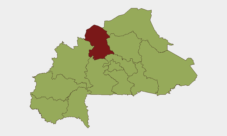
Highest-Risk Areas
The North region (risk score 82) stands significantly above all others and is the primary driver of Burkina Faso's national threat ranking. The remaining 11 regions cluster at risk score 52, indicating that while the northern provinces (particularly around Oudalan and Soum) experience the most intense insurgent activity and state counteroperations, conflict pressure is now distributed across the Sahel, Upper-Basins, Central zones, and eastern corridors. This diffusion reflects the maturation and decentralization of militant networks; corporate and humanitarian operations cannot assume safety outside the North, and mobility restrictions now affect much of the country.
How GeoBit Would Assist
Security teams should deploy AOI Monitoring & Early Warning with persistent watch on the North region and key transport corridors (Ouagadougou–Bobo-Dioulasso, Ouagadougou–Niamey border, and Sahel supply routes) to capture incident alerts before staff or supply movements encounter active conflict zones. Intel Sweep and multi-language OSINT fusion—including Telegram militant channels, local radio SIGINT, and sentiment analysis of social media by region—will surface operational tempo shifts and checkpoint establishment in real time. Routing & Network Analysis should model alternative journey plans that account for current insurgent presence and state security force positions, reducing exposure to ambush corridors. Together, these capabilities enable duty-of-care teams to make timely evacuation, relocation, or supply-chain decisions without relying solely on 24–48-hour lags in open reporting.
7-Day Outlook
No specific incident trend is visible in the immediate 6-day window; however, the broader security trajectory remains downward. The state's security crackdown on civil-society organizations and religious institutions suggests continued friction between government counterinsurgency operations and civilian populations, which historically precedes localized unrest or militant recruitment spikes. Teams should anticipate persistent operational constraints in the North and elevated checkpoint/harassment risk across central regions, with no imminent de-escalation signaled.
Highest-Risk Areas — Ranked
| # | State / Region | Risk |
|---|---|---|
| 1 | North | 82 |
| 2 | Upper-Basins | 52 |
| 3 | Boucle du Mouhoun | 52 |
| 4 | Central-West | 52 |
| 5 | Central-South | 52 |
| 6 | Central-East | 52 |
| 7 | Waterfalls | 52 |
| 8 | Southwest | 52 |
| 9 | Sahel | 52 |
| 10 | Central-North | 52 |
| 11 | East | 52 |
| 12 | Centre | 52 |
Sources
Previous Daily Briefs
A new Burkina Faso brief is written every day — each with its own risk map and downloadable CSV. Here's the last week; use the calendar to go further back.
📅 Browse every day by calendar →
Highlighted days have a brief. Tap a day for that day's map & analysis, or “csv” for that day's dataset ($5).