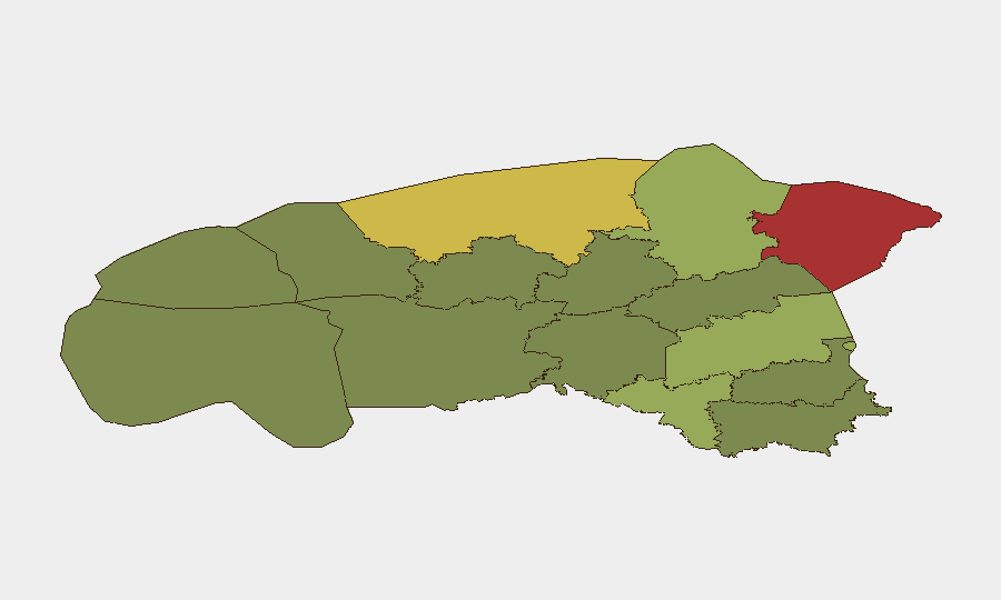
Situation Summary
Estonia maintains a low-incident security posture with no confirmed location-specific security events in the last 24–48 hours. The country's composite threat score of 6 (ranked #150 globally) reflects routine baseline conditions, though this stability exists within a broader regional context of Russia–Ukraine tensions and ongoing cross-border drone activity. No imminent kinetic or civil unrest threats are indicated in current intelligence.
Key Developments
- No discrete security incidents confirmed in Estonia, 2026-07-03 to 2026-07-05. Web and news aggregator monitoring across Estonia-wide, county-level, and major urban areas (Tallinn, Tartu) identified no newly emerged violent incidents, infrastructure disruptions, political unrest, or travel-risk events in the last 24–48 hours.
- Estonia–Ukraine diplomatic stance remains unchanged. Government position (reaffirmed in late June–early July reporting) confirms Estonia will not pressure Ukraine to curtail long-range strikes on Russian targets, sustaining prior months' strategic posture. No new diplomatic incident or formal statement triggered this update.
- Ida-Viru County risk elevation reflects sustained, not emergent, factors. The highest sub-national risk score (78) in Estonia's northeast reflects proximity to Russian border, historical drone debris incidents (documented over prior months, not in last 48 hours), and baseline cross-border tension—not a new localized incident.
- Regional tension context: Ukraine–Estonia signal activity (2026-07-03 to 2026-07-04). GeoBit event signals flagged demand and reject interactions between Ukraine and Estonia on 2026-07-04 and 2026-07-03 respectively. Web corroboration did not surface a publicly reported bilateral dispute or agreement; signals may reflect diplomatic routine or internal administrative traffic.
- No infrastructure, cyber, or aviation incidents reported. Monitoring of Tallinn Airport, port facilities, and critical infrastructure revealed no disruptions or alerts in the 24–48-hour window.
Highest-Risk Areas
Ida-Viru County (risk 78) and Harju County (risk 68) dominate Estonia's risk profile. Ida-Viru's elevation is driven by geographic proximity to the Russian border, cumulative cross-border drone incidents over prior months, and baseline military-adjacent sensitivity; Harju County (which includes Tallinn) reflects concentration of national infrastructure, diplomatic presence, and population density. Tartu County (risk 58) and Valga County (risk 55) represent secondary concern zones, with Valga's southern border proximity to both Russia and Latvia adding minor cross-border considerations. Remaining counties (Pärnu, Rapla, Jõgeva, Järva, Viljandi, Põlva, Võru) carry low to minimal scores, indicating routine security environments.
How GeoBit Would Assist
Security teams monitoring Estonia would leverage AOI Monitoring & Early Warning on Ida-Viru and Harju counties to detect rapid changes in cross-border activity, drone debris incidents, or infrastructure disruptions with automated alerting. Intel Sweep (global event feeds, multi-language OSINT, Telegram/X monitoring) provides continuous horizon scanning for diplomatic friction, cyber incidents, or regional escalation signals. Routing & Network Analysis supports contingency planning for personnel or asset movements, particularly in border-proximate counties, by identifying alternative routes and risk corridors.
7-Day Outlook
Estonia is expected to remain in a low-incident, routine operating environment through 2026-07-12, barring unforeseen regional escalation or cross-border incidents. Diplomatic and military postures are stable. Teams should maintain standard duty-of-care monitoring and contingency readiness, particularly for assets or personnel in Ida-Viru and Harju counties.
Highest-Risk Areas — Ranked
| # | State / Region | Risk |
|---|---|---|
| 1 | Ida-Viru County | 78 |
| 2 | Harju County | 68 |
| 3 | Tartu County | 58 |
| 4 | Valga County | 55 |
| 5 | Lääne-Viru County | 52 |
| 6 | Pärnu County | 35 |
| 7 | Rapla County | 32 |
| 8 | Jõgeva County | 30 |
| 9 | Järva County | 28 |
| 10 | Viljandi County | 25 |
| 11 | Põlva County | 22 |
| 12 | Võru County | 18 |
Sources
Previous Daily Briefs
A new Estonia brief is written every day — each with its own risk map and downloadable CSV. Here's the last week; use the calendar to go further back.
📅 Browse every day by calendar →
Highlighted days have a brief. Tap a day for that day's map & analysis, or “csv” for that day's dataset ($5).
Atlas — our AI intelligence desk — emails them this snapshot personally. Nothing else, no list.