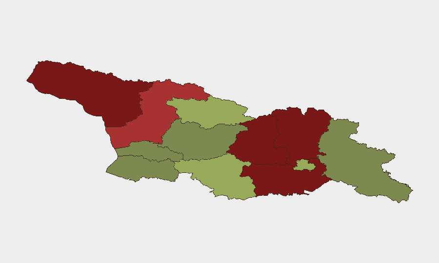
Situation Summary
Georgia remains a moderate-risk environment (rank #72 globally, composite score 15) with 18 tracked security events, concentrated heavily in the separatist-held territories of Abkhazia and South Ossetia and along the Russian border. Recent signals (7–6 July) include police arrests, military activity attributed to criminal actors, ministerial and legal statements, and voter disapproval, suggesting internal political tension alongside persistent territorial instability. Flooding in multiple regions adds a secondary infrastructure and humanitarian dimension. The security picture is stable relative to historical baselines but reflects ongoing governance fragility in disputed areas and border-zone volatility.
Key Developments
- 2026-07-06 · Police arrest/detention action — Location and incident details not yet specified in available signals; ministerial statement issued same day suggests official response to a significant event.
- 2026-07-06 · Military activity flagged (criminal-attributed) — Conventional force event recorded; location and operational scope require additional corroboration.
- 2026-07-05 · Legal/lawyer statement — Suggestive of formal challenge or grievance filing; likely tied to arrest or detention action above.
- 2026-07-05 · European disapproval/threat statement — International reaction; suggests breach of agreement, sanction risk, or diplomatic escalation.
- 2026-07-06 · Settlement/community statement — Local-level response or announcement; context unclear without incident details.
- Flood events (recent, unspecified date) — Two separate flood incidents logged (IDs 1103979, 1103959); impact on roads, power, water supply, and humanitarian access in affected regions not yet quantified.
*Note: Specific locations, casualty counts, and detailed timelines for these events are not available from current web research. Corporate security teams with operations in Georgia should escalate to primary local sources (Georgian Interior Ministry, Emergency Situations Agency, international media wires) for real-time incident verification and operational impact assessment.*
Highest-Risk Areas
Abkhazia (risk 95) and South Ossetia (Shida Kartli, risk 88) dominate the threat landscape, driven by unresolved territorial status, Russian military presence, and limited Georgian state authority. Lower Kartli (85) and Mtskheta-Mtianeti (82) reflect border-zone vulnerability and spillover risk from North Caucasus instability. Samegrelo-Upper Svaneti (78) adds trafficking and transnational crime dimensions. By contrast, Tbilisi (45), Imereti (32), and southern Autonomous Republics (Adjara 35) carry substantially lower composite risk, though capital-based political tension and sectarian dynamics warrant monitoring. Recent flooding may temporarily elevate risk in affected districts via infrastructure disruption and humanitarian access constraints.
How GeoBit Would Assist
Intel Sweep & OSINT Fusion: Continuous monitoring of Georgian Interior Ministry feeds, local news wires, X/Twitter OSINT (police, NGO, and citizen reporting), and Telegram channels in Abkhazia, South Ossetia, and border zones to identify arrests, military movement, and protest activity in real time. AOI Monitoring & Early Warning: Persistent geolocation watch on Tbilisi, Gori, and Zugdidi to flag political gatherings, security force repositioning, or civil unrest, with automated alerts for duty-of-care triggers. Network & Actor Analysis: Mapping of Georgian Interior Ministry, prosecutor, and local settlement actors to understand decision-making velocity and escalation pathways during crises. Satellite & Imagery + GIS: Assessment of flood extent, bridge/road closure, and humanitarian access routes in affected regions to support contingency planning.
7-Day Outlook
Political tension (arrests, legal disputes, voter disapproval) is likely to sustain mid-week; no imminent large-scale unrest is evident, but rhetoric may sharpen ahead of potential parliamentary or judicial developments. Flood recovery will remain operationally relevant in affected zones, particularly for supply-chain and personnel routing. Border and separatist-zone volatility remains chronic; no acute military escalation is signaled, but Russian posture and EU rhetoric suggest sustained diplomatic friction.
Highest-Risk Areas — Ranked
| # | State / Region | Risk |
|---|---|---|
| 1 | Autonomous Republic of Abkhazia | 95 |
| 2 | Shida Kartli | 88 |
| 3 | Lower Kartli | 85 |
| 4 | Mtskheta-Mtianeti | 82 |
| 5 | Samegrelo-Upper Svaneti | 78 |
| 6 | Samtskhe-Javakheti | 48 |
| 7 | Tbilisi | 45 |
| 8 | Racha-Lechkhumi and Kvemo Svaneti | 42 |
| 9 | Kakheti | 38 |
| 10 | Autonomous Republic of Adjara | 35 |
| 11 | Imereti | 32 |
| 12 | Guria | 28 |
Sources
Previous Daily Briefs
A new Georgia brief is written every day — each with its own risk map and downloadable CSV. Here's the last week; use the calendar to go further back.
📅 Browse every day by calendar →
Highlighted days have a brief. Tap a day for that day's map & analysis, or “csv” for that day's dataset ($5).
Atlas — our AI intelligence desk — emails them this snapshot personally. Nothing else, no list.