Situation Summary
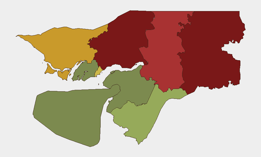
Guinea-Bissau remains a stable low-threat environment globally (ranked #59 with composite score 21), with no verified security incidents or civil unrest reported in the last 24–48 hours. The country's risk profile is driven by structural vulnerabilities in its northern and eastern regions rather than acute, active conflict. Open-source monitoring shows routine governance and administrative activity with no indicators of imminent destabilization or widespread security deterioration.
Key Developments
No discrete security, conflict, civil-unrest, crime, or infrastructure incidents have been corroborated from open-source channels in Guinea-Bissau within the last 24–48 hours. Available reporting focuses on regional West Africa developments in other countries; Guinea-Bissau is referenced only in broader structural risk assessments, not as a location of current incidents. Airline operations, maritime traffic, and routine diplomatic/administrative channels show no indicators of border closures, curfews, or service disruptions. Social media commentary on Guinea-Bissau lacks independent verification and does not meet confirmation criteria for discrete events.
Highest-Risk Areas
Gabu Region (risk 92), Oio Region (risk 85), and Bafatá Region (risk 78) are the primary drivers of Guinea-Bissau's sub-national risk profile. These northern and eastern regions face elevated exposure to cross-border activity, trafficking networks, and historical governance challenges. By contrast, southern regions—particularly Bolama (risk 15) and Quinara (risk 38)—present substantially lower risk. Bissau Autonomous Sector (risk 68) warrants attention as the capital and administrative center, though it remains below the threat intensity of the three northern regions. Teams with operations in Gabu, Oio, or Bafatá should apply heightened due-diligence protocols relative to other areas.
How GeoBit Would Assist
GeoBit's AOI (Area-of-Interest) Monitoring & Early Warning capability would provide persistent watch on Gabu, Oio, and Bafatá regions with automated alerting on emerging incidents, enabling corporate teams to detect risks before they escalate. Intel Sweep combined with multi-language OSINT and X/Twitter & Telegram OSINT would maintain real-time situational awareness across key cities and border zones, capturing early signals of unrest, trafficking, or administrative changes. Routing & Network Analysis would support duty-of-care teams in planning safer travel corridors and alternative routes for personnel or shipments transiting high-risk regions.
7-Day Outlook
No near-term indicators suggest acute security deterioration or major incidents in Guinea-Bissau over the next seven days. The country's risk trajectory remains constrained by structural factors rather than active conflict drivers; barring unforeseen external shocks or regional spillover, the current low-event environment is expected to persist. Teams should maintain standard baseline monitoring protocols, with enhanced focus on the three northern regions and any emerging political or cross-border signals.
Highest-Risk Areas — Ranked
| # | State / Region | Risk |
|---|---|---|
| 1 | Gabu Region | 92 |
| 2 | Oio Region | 85 |
| 3 | Bafatá Region | 78 |
| 4 | Cacheu Region | 72 |
| 5 | Bissau Autonomous Sector | 68 |
| 6 | Tombali Region | 45 |
| 7 | Quinara Region | 38 |
| 8 | Biombo Region | 32 |
| 9 | Bolama Region | 15 |
Sources
Previous Daily Briefs
A new Guinea-Bissau brief is written every day — each with its own risk map and downloadable CSV. Here's the last week; use the calendar to go further back.
📅 Browse every day by calendar →
Highlighted days have a brief. Tap a day for that day's map & analysis, or “csv” for that day's dataset ($5).
Atlas — our AI intelligence desk — emails them this snapshot personally. Nothing else, no list.