Situation Summary
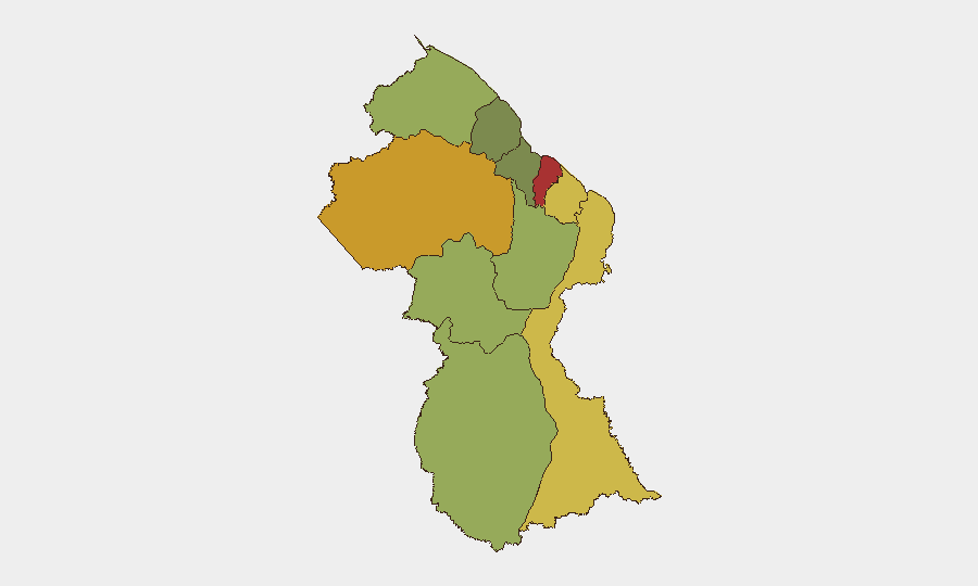
Guyana remains at low-to-moderate composite threat level (rank #69 globally, score 19) with no confirmed security incidents, civil unrest, crime spikes, or infrastructure disruption reported in the last 24–48 hours. Recent activity signals include territorial occupation and public statements from domestic actors, alongside international statements from the US and UK, but available open-source reporting does not corroborate associated violence or instability. The security environment is stable but geographically fragmented, with coastal urban regions (Demerara-Mahaica, Cuyuni-Mazaruni) carrying elevated risk profiles compared to interior and island zones.
Key Developments
- Anna Regina, Pomeroon-Supenaam – 3 July 2026: Government of Guyana proceeding with commissioning of Anna Regina Cricket Stadium, a scheduled public event featuring President Irfaan Ali. No associated protest activity, security incident, or disruption confirmed.
- Georgetown / Online Discourse – 2–3 July 2026: Guyanese public statements and US/UK diplomatic statements recorded (dates 2–3 July); content and strategic intent not detailed in available open reporting. No incident or unrest corroboration.
- Stewartville (location unconfirmed) – Late June to 3 July 2026: Localized social-media grievances regarding housing conditions and calls to "fix the Stewartville problem by July 3rd 2026" noted in Facebook discourse; no confirmed protests, blockades, or security response reported.
- Territorial Occupation Events – 30 June–3 July 2026: Two separate territorial occupation events attributed to Guyanese actors recorded; no casualty reports, state response, or associated conflict incident confirmed in open sources.
- Investigative Action – 1 July 2026: Georgetown authorities initiated investigation regarding Rastafarian community (specific trigger and outcome not reported in available web research).
- Senatorial Rejection – 2 July 2026: Unnamed senator issued rejection statement (context and target not detailed in available reporting).
Highest-Risk Areas
Demerara-Mahaica (risk 78) and Cuyuni-Mazaruni (risk 72) are the primary drivers of national composite threat, together accounting for a disproportionate share of tracked security events. Both regions are coastal or near-coastal zones with higher population density, economic activity, and political visibility. Mahaica-Berbice (65) and East Berbice-Corentyne (62) follow; these eastern coastal regions also concentrate urban centers and cross-border dynamics. Interior and island regions (Potaro-Siparuni, Barima-Waini, Essequibo Islands) carry significantly lower risk profiles, suggesting that organized crime, political tension, and enforcement activity remain concentrated in accessible, densely settled corridors.
How GeoBit Would Assist
Teams with people or assets in Guyana should employ AOI Monitoring & Early Warning on Demerara-Mahaica and Cuyuni-Mazaruni to detect emerging protest, crime, or cross-border activity in real time. OSINT Fusion & Corroboration (X/Twitter, Telegram, Facebook, local news) across multiple languages is critical to validate or refute social-media grievances and track territorial occupation claims before they escalate. Risk & Threat Assessment tools should continuously ingest electoral, regime-stability, and crime-trend data to anticipate flashpoints ahead of major public events (stadium commissioning, housing announcements).
7-Day Outlook
No significant security deterioration is forecast for the next seven days. The Anna Regina stadium event (3 July) is proceeding without disruption; Stewartville housing grievances remain in the social-discourse phase with no confirmed mobilization. Monitoring should remain vigilant for cross-border activity in eastern regions and any escalation of territorial claims, but baseline conditions support routine operations for most corporate and NGO activity.
Highest-Risk Areas — Ranked
| # | State / Region | Risk |
|---|---|---|
| 1 | Demerara-Mahaica | 78 |
| 2 | Cuyuni-Mazaruni | 72 |
| 3 | Mahaica-Berbice | 65 |
| 4 | East Berbice-Corentyne | 62 |
| 5 | Upper Demerara-Berbice | 58 |
| 6 | Potaro-Siparuni | 48 |
| 7 | Barima-Waini | 45 |
| 8 | Upper Takutu-Upper Essequibo | 42 |
| 9 | Pomeroon-Supenaam | 38 |
| 10 | Essequibo Islands | 35 |
Previous Daily Briefs
A new Guyana brief is written every day — each with its own risk map and downloadable CSV. Here's the last week; use the calendar to go further back.
📅 Browse every day by calendar →
Highlighted days have a brief. Tap a day for that day's map & analysis, or “csv” for that day's dataset ($5).